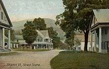
Sharon, Vermont
| Sharon, Vermont | |
|---|---|
| Town | |
|
Baxter Memorial Library | |
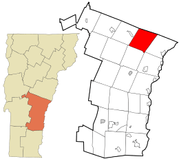 Location in Windsor County and the state of Vermont. | |
 Location of Vermont in the U.S.A. | |
| Coordinates: 43°46′25″N 72°26′38″W / 43.77361°N 72.44389°WCoordinates: 43°46′25″N 72°26′38″W / 43.77361°N 72.44389°W | |
| Country | United States |
| State | Vermont |
| County | Windsor |
| Chartered | 1761 |
| Area | |
| • Total | 40.1 sq mi (103.8 km2) |
| • Land | 39.6 sq mi (102.6 km2) |
| • Water | 0.5 sq mi (1.2 km2) |
| Elevation | 500 ft (449 m) |
| Population (2010) | |
| • Total | 1,502 |
| • Density | 37/sq mi (14/km2) |
| Time zone | EST (UTC-5) |
| • Summer (DST) | EDT (UTC-4) |
| ZIP code | 05065 |
| Area code(s) | 802 |
| FIPS code | 50-63775[1] |
| GNIS feature ID | 1462204[2] |
| Website |
www |

Sharon is a town in Windsor County, Vermont, United States. It had a population of 1,502 at the 2010 census.[3]
Sharon was the birthplace of Joseph Smith, founder of the Latter Day Saint movement, and as such is an important historical site for Latter Day Saints. The town is also home to The Sharon Academy, an independent middle and high school.
History
One of the New Hampshire grants, the township was created on August 17, 1761, by a royal charter which King George III of the United Kingdom issued to Governor Benning Wentworth.[4] It was granted to John Taylor and 61 others, many from Sharon, Connecticut. The town was first settled about 1765 by Robert Havens and family. In 1780 during the Revolution, the village was attacked in the Royalton Raid,[5] when a combined force of British soldiers and Indians burned houses and killed livestock.
Although the surface of the town is very broken, the intervales contain fertile soil, and farming became an important industry. On June 26, 1848, the Vermont Central Railroad opened from White River Junction to Bethel, traversing Sharon and accelerating its development. The White River and its tributaries provided water power for mills. By 1859, when the population reached 1,240, Sharon had 12 sawmills, a gristmill, and a bobbin factory.[5]
In the mid-20th century the main form of employment in Sharon was still the lumber industry.[6]
Geography
According to the United States Census Bureau, the town has a total area of 40.1 square miles (103.9 km2), of which 39.6 square miles (102.6 km2) is land and 0.5 square mile (1.2 km2) (1.20%) is water. Sharon is drained by the White River and its tributaries.
The town is crossed by Interstate 89, Vermont Route 14 and Vermont Route 132.
Demographics
| Historical population | |||
|---|---|---|---|
| Census | Pop. | %± | |
| 1790 | 569 | — | |
| 1800 | 1,158 | 103.5% | |
| 1810 | 1,363 | 17.7% | |
| 1820 | 1,431 | 5.0% | |
| 1830 | 1,459 | 2.0% | |
| 1840 | 1,371 | −6.0% | |
| 1850 | 1,240 | −9.6% | |
| 1860 | 1,111 | −10.4% | |
| 1870 | 1,013 | −8.8% | |
| 1880 | 1,012 | −0.1% | |
| 1890 | 737 | −27.2% | |
| 1900 | 709 | −3.8% | |
| 1910 | 585 | −17.5% | |
| 1920 | 545 | −6.8% | |
| 1930 | 569 | 4.4% | |
| 1940 | 530 | −6.9% | |
| 1950 | 470 | −11.3% | |
| 1960 | 485 | 3.2% | |
| 1970 | 541 | 11.5% | |
| 1980 | 828 | 53.0% | |
| 1990 | 1,211 | 46.3% | |
| 2000 | 1,411 | 16.5% | |
| 2010 | 1,502 | 6.4% | |
| Est. 2014 | 1,495 | [7] | −0.5% |
| U.S. Decennial Census[8] | |||
As of the census[1] of 2000, there were 1,411 people, 553 households, and 378 families residing in the town. The population density was 35.6 people per square mile (13.8/km2). There were 663 housing units at an average density of 16.7 per square mile (6.5/km2). The racial makeup of the town was 97.17% White, 0.57% African American, 0.43% Native American, 0.64% Asian, and 1.20% from two or more races. Hispanic or Latino of any race were 0.99% of the population.
There were 553 households out of which 36.5% had children under the age of 18 living with them, 58.0% were married couples living together, 7.4% had a female householder with no husband present, and 31.5% were non-families. 24.6% of all households were made up of individuals and 6.9% had someone living alone who was 65 years of age or older. The average household size was 2.55 and the average family size was 3.06.
In the town the population was spread out with 27.8% under the age of 18, 5.7% from 18 to 24, 30.4% from 25 to 44, 28.2% from 45 to 64, and 7.9% who were 65 years of age or older. The median age was 38 years. For every 100 females there were 102.4 males. For every 100 females age 18 and over, there were 102.2 males. The median age of the population was 37.
The median income for a household in the town was $40,952, and the median income for a family was $47,500. Males had a median income of $32,112 versus $28,472 for females. The per capita income for the town was $20,824. About 5.3% of families and 7.3% of the population were below the poverty line, including 5.5% of those under age 18 and 9.4% of those age 65 or over.
2010 census
As of the 2010 Census Sharon had a population of 1,502. The median age was 44 years old. The population was 95.5% non-Hispanic white, 0.9% African-American, 0.4% Native American, 0.7% Asian, 0.1% reporting some other race, 1.3% reporting two or more races and 1.2% Hispanic or Latino.[9]
Sites of interest
- Joseph Smith Birthplace Memorial
- Sharon Historical Society & Museum
- The Sharon Academy
- Baxter Memorial Library
Notable people
- Jason Downer, justice of the Wisconsin Supreme Court
- Robby Mook, political campaign strategist, campaign manager for Hillary Clinton[10]
- Joseph Smith, founder of the Latter Day Saint movement
- John Spaulding, Vermont State Treasurer
- Charley Parkhurst, famous stagecoach driver
References
- 1 2 "American FactFinder". United States Census Bureau. Retrieved 2008-01-31.
- ↑ "US Board on Geographic Names". United States Geological Survey. 2007-10-25. Retrieved 2008-01-31.
- ↑ "Profile of General Population and Housing Characteristics: 2010 Demographic Profile Data (DP-1): Sharon town, Windsor County, Vermont". U.S. Census Bureau, American Factfinder. Retrieved August 1, 2012.
- ↑ Virtual Vermont -- Sharon, Vermont
- 1 2 A. J. Coolidge & J. B. Mansfield, A History and Description of New England; Boston, Massachusetts 1859
- ↑ Columbia Lipincott Gazeteer, 1952 editon, p. 1745.
- ↑ "Annual Estimates of the Resident Population for Incorporated Places: April 1, 2010 to July 1, 2014". Retrieved June 4, 2015.
- ↑ "U.S. Decennial Census". United States Census Bureau. Retrieved May 16, 2015.
- ↑ 2010 census report on Sharon, Vermont
- ↑ Heintz, Paul (September 18, 2013). "Take Back Virginia? Old Dominion Dems Are Counting on Vermont-Born Robby Mook". Seven Days. Retrieved October 4, 2013.
External links
Municipalities and communities of Windsor County, Vermont, United States | ||
|---|---|---|
| Towns | 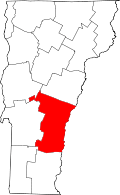 | |
| Villages | ||
| CDPs | ||
| Other communities | ||