Sharon, Massachusetts
| Sharon, Massachusetts | ||
|---|---|---|
| Town | ||
|
Town center | ||
| ||
| Motto: A nice place to live because it's naturally beautiful.[1] | ||
 Location in Norfolk County in Massachusetts | ||
| Coordinates: 42°6′46″N 71°11′2″W / 42.11278°N 71.18389°W | ||
| Country | United States | |
| State | Massachusetts | |
| County | Norfolk | |
| Settled | 1650 | |
| Incorporated | 1775 | |
| Government | ||
| • Type | Open town meeting | |
| • Town Administrator | Frederic E. Turkington, Jr. | |
| • Board of Selectmen |
Walter "Joe" Roach John J. McGrath William A. Heitin | |
| Area | ||
| • Total | 24.2 sq mi (62.6 km2) | |
| • Land | 23.3 sq mi (60.4 km2) | |
| • Water | 0.9 sq mi (2.2 km2) 3.56% | |
| Elevation | 249 ft (76 m) | |
| Population (2010) | ||
| • Total | 17,612 | |
| • Density | 755.9/sq mi (291.6/km2) | |
| Time zone | EST (UTC-5) | |
| • Summer (DST) | Eastern (UTC-4) | |
| ZIP code | 02067 | |
| Area code(s) | 339 / 781 | |
| FIPS code | 25-60785 | |
| GNIS feature ID | 0618329 | |
| Website | http://www.townofsharon.net/ | |

Sharon is a town in Norfolk County, Massachusetts, United States. The population was 17,612 at the 2010 census. Sharon is part of Greater Boston, about 17 miles (27 km) southwest of downtown Boston.
History
Sharon, first settled as part of the Massachusetts Bay Colony in 1637, was deemed the 2nd precinct of Stoughton in 1740. It was established as the district of Stoughtonham on June 21, 1765, incorporated as the Town of Stoughtonham on August 23, 1775 and was named Sharon on February 25, 1783 after Israel's Sharon plain, due to its high level of forestation. Several towns in New England were given this name. Part of Stoughtonham went to the new town of Foxborough on June 10, 1776. During the American Revolution, the townspeople of Sharon made cannonballs and cannons for the Continental Army at a local foundry.
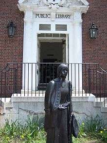
In front of the Sharon Public Library stands a statue of Deborah Sampson, Sharon's town heroine. Sampson disguised herself as a man to fight in the Revolutionary War. She married Benjamin Gannett, a farmer, after she fought in the war and lived in Sharon until the end of her life. She is buried in the local Rockridge Cemetery. A street in Sharon is named Deborah Sampson Street in her honor.
The Unitarian and Congregational churches in the center of Sharon both have church bells manufactured by Paul Revere.
The recipient of letters from across the United States in Stanley Milgram's small-world experiment lived in Sharon.
Geography
According to the United States Census Bureau, the town has a total area of 24.2 square miles (62.6 km²), of which, 23.3 square miles (60.4 km²) is land and 0.9 square miles (2.2 km²) (3.56%) is water. This includes Lake Massapoag, which is one of the town's most prominent features and a popular recreational site for swimming and boating. It was largely responsible for the town's early development as a summer resort location. Sharon is drained by the Canoe River to the south, and Massapoag Brook to the north.
Climate
Sharon is located in a continental climate, like most of New England and most of the Northeastern and Midwestern United States. It is cooler than coastal New England locations because it is inland. The town has warm to hot summers and cold winters. It is often humid in the summer. Sharon receives about 50 inches of precipitation every year on average.
| Climate data for Sharon, MA | |||||||||||||
|---|---|---|---|---|---|---|---|---|---|---|---|---|---|
| Month | Jan | Feb | Mar | Apr | May | Jun | Jul | Aug | Sep | Oct | Nov | Dec | Year |
| Average high °F (°C) | 36 (2) |
40 (4) |
48 (9) |
59 (15) |
70 (21) |
78 (26) |
83 (28) |
81 (27) |
73 (23) |
62 (17) |
52 (11) |
41 (5) |
60.3 (15.7) |
| Average low °F (°C) | 18 (−8) |
21 (−6) |
28 (−2) |
37 (3) |
47 (8) |
57 (14) |
62 (17) |
61 (16) |
53 (12) |
42 (6) |
33 (1) |
24 (−4) |
40.3 (4.8) |
| Average precipitation inches (mm) | 3.78 (96) |
3.68 (93.5) |
4.81 (122.2) |
4.39 (111.5) |
3.65 (92.7) |
4.08 (103.6) |
3.91 (99.3) |
3.91 (99.3) |
3.66 (93) |
4.35 (110.5) |
4.46 (113.3) |
4.52 (114.8) |
49.2 (1,249.7) |
| Source: [2] | |||||||||||||
Adjacent towns
Sharon is located in eastern Massachusetts, bordered by the following towns:
- Canton to the northeast
- Norwood to the north
- Walpole to the northwest
- Foxborough to the west
- Stoughton to the east
- Easton to the southeast
- Mansfield to the south
Nature trails
Sharon has a large number of scenic trails due to the high percentage of conservation land within the town's borders. Trails found in Sharon include the Massapoag Trail, the Warner Trail, the Bay Circuit Trail (otherwise known as the Beaver Brook Trail), and the King Philip's Rock Trail. There are a number of trails at Borderland State Park and at Moose Hill Wildlife Sanctuary.
Demographics
| Historical population | ||
|---|---|---|
| Year | Pop. | ±% |
| 1850 | 1,128 | — |
| 1860 | 1,377 | +22.1% |
| 1870 | 1,508 | +9.5% |
| 1880 | 1,492 | −1.1% |
| 1890 | 1,634 | +9.5% |
| 1900 | 2,060 | +26.1% |
| 1910 | 2,310 | +12.1% |
| 1920 | 2,467 | +6.8% |
| 1930 | 3,351 | +35.8% |
| 1940 | 3,737 | +11.5% |
| 1950 | 4,847 | +29.7% |
| 1960 | 10,070 | +107.8% |
| 1970 | 12,367 | +22.8% |
| 1980 | 13,601 | +10.0% |
| 1990 | 15,517 | +14.1% |
| 2000 | 17,408 | +12.2% |
| 2010 | 17,612 | +1.2% |
| * = population estimate. Source: United States Census records and Population Estimates Program data.[3][4][5][6][7][8][9][10][11][12] | ||
As of the census[13] of 2010, there were 17,612 people, 6,219 households and 5,039 families residing in the town. The population density was 747.0 people per square mile (288.3/km²). There were 6,026 housing units at an average density of 258.6 per square mile (99.8/km²).
As of 2010, the racial makeup of the town was 82.3% White, 4.2% African American, 0.1% Native American, 10.9% Asian, 0.01% Pacific Islander, 0.6% from other races and 1.8% from two or more races. Hispanic or Latino of any race were 2.1% of the population. According to the American Community Survey administered in 2014, the racial makeup of the town was 76.0% White, 4.2% African American, 0.1% Native American, 16.6% Asian, 0.0% Pacific Islander, 0.4% from other races and 2.7% from two or more races, with Hispanic or Latino of any race at 2.5% of the population.
22.5% of the population speaks a language other than English at home, and 19.2% of the population was born outside of the United States.[14] Sharon has the state's highest proportion of Russian immigrants, estimated at 14.4% in 2010.[15]
Of the 6,219 households, 42.4% had children under the age of 18 living with them, 70.7% were married couples living together, 7.7% had a female householder with no husband present, 2.6% had a male householder with no wife present, and 19.0% were non-families. 16.1% of all households were made up of individuals and 7.5% had someone living alone who was 65 years of age or older. The average household size was 2.82 people and the average family size was 3.17 people.
The population was spread out with 27.3% under the age of 18, 5.3% from 18 to 24, 20.0% from 25 to 44, 34.7% from 45 to 64 and 12.7% who were 65 years of age or older. The median age was 43.3 years. For every 100 females there were 93.2 males. For every 100 females age 18 and over, there were 90.6 males.
As of 2014,[16] the median income for a household in the town was $127,413 and the median income for a family was $144,167. Males had a median income of $100,951 versus $72,917 for females. The per capita income for the town was $56,465. About 1.1% of families and 2.7% of the population were below the poverty line, including 3.0% of those under age 18 and 3.9% of those age 65 or over.
According to the 2014 American Community Survey,[17] 97.6% of adults in Sharon are high school graduates, and 72.8% have a bachelor's degree or higher. Of those 25 and older, 11.3% have completed some college but do not have a degree, 4.7% have an associate's degree, 34.7% have a bachelor's degree, and 37.7% have a graduate or professional degree.
Sharon is home to 7 synagogues, 9 churches, and one of the largest mosques in New England.[18]
Government and politics
Sharon currently has an Open Town Meeting form of government, with three Selectmen. In 2008, a commission was elected to prepare a charter document specifying the executive, legislative, and administrative structure of town government. It considered whether the town should retain its current government form or change to a representative form. There was a debate, whether the town has outgrown Open Town Meeting, where decisions are made only by those attending (they must be present to vote) or whether direct-vote government works well because residents who choose to attend are particularly interested in and informed on the issues. In November 2009, the charter commission recommended a "hybrid" legislative branch consisting of a Legislative Committee (Representative Town Meeting of 17 members) and an Open Town Meeting (which could be called to review the Legislative Committee's decisions if 3% of voters signed a "review petition"). At a town election on May 18, 2010, the charter proposal was rejected by a vote of 1123 yes, 2305 no.
As of February 2016, there are 12,383 registered voters in Sharon. 4,050 (32.7%) are enrolled as Democrats, 968 (7.8%) are enrolled as Republicans, 7,330 (59.2%) do not belong to a party, and 12 belong to other parties.[19]
In the 2012 presidential election, Barack Obama carried Sharon with 63% of the vote, while Mitt Romney received 35%.[20] The same year, Democrat Elizabeth Warren won Sharon with 57% of the vote, defeating incumbent Republican senator Scott Brown, who received 43% of the vote in the town.
Sharon is in Massachusetts' 4th congressional district, and is currently represented in the U.S. House of Representatives by Joseph P. Kennedy III and in the U.S. Senate by Elizabeth Warren and Ed Markey.
Education
The Sharon Public Schools system has five schools. Grades K-5 attend one of the three elementary schools: East, Cottage, and Heights. Grades 6-8 attend Sharon Middle School, and grades 9-12 attend Sharon High School. The middle school and high school sports teams are known as the Eagles. The school system is noted for its outstanding academic performance and learning curriculum. Sharon Middle School (SMS) and Sharon High School (SHS) both have athletic fields including baseball, football, and soccer fields, as well as tennis courts. In 2011, Sharon High School was awarded the National Blue Ribbon Schools award by the U.S. Department of Education. It was one of two schools in Massachusetts to receive the award.[21] In the 2013-2014 school year, the AP participation rate at Sharon High School was 60%, and the participant passing rate was 97%.[22]
Transportation
Commuter rail service from Boston's South Station is provided by the MBTA with a stop in Sharon on its Providence/Stoughton Line. There are no public bus or subway lines in Sharon.
Exit 8 of Interstate 95 is on the Sharon/Foxborough border, with access to both the northbound and southbound directions of the highway. Exit 10 of Interstate 95 is on the Sharon/Walpole line, with access to the northbound direction of the highway and from the southbound direction.
In addition, Massachusetts Route 27 runs through the center of the town.
Notable people
- Mildred Allen, physicist
- Tully Banta-Cain, NFL player
- Leonard Bernstein, composer (summer resident)
- Etan Cohen, screenwriter
- Arthur Vining Davis, industrialist and philanthropist
- Tommy Harper, baseball player
- Amasa Hewins, portrait, genre and landscape painter
- Roland James, football defensive back
- Sam Jones, Boston Celtics basketball player
- Myron Kaufmann, (NY Times best selling) novelist
- Bill Keating, congressman
- Henry Way Kendall, physicist, Nobel laureate
- Ty Law, football cornerback
- Jack Levin, criminologist
- John McLaughlin, artist
- Sarah Palfrey Cooke, U.S. tennis champion[23]
- Bruce Pearl, basketball coach
- Frank Salemme, Italian/Irish mobster and former boss of Patriarca crime family
- Deborah Sampson, Revolutionary era heroine
- Pete Seibert, ski resort founder
- Andre Tippett, football linebacker (Hall of Fame)
- Charles Q. Tirrell, congressman
- Terrence Wheatley, football cornerback
- Nick Zinner, guitarist
In popular culture
- In Jhumpa Lahiri's Unaccustomed Earth, Hema's family in the story "Once in a Lifetime" lives in Sharon.
- Daytime footage for Shutter Island was taken in Borderland State Park; a property shared with the neighboring town of Easton
- The well-known 1973 film "The Friends of Eddie Coyle" starring Robert Mitchum includes a scene filmed in Sharon. The following NYT film criticism excerpt shows the Sharon commuter rail station circa 1973.
In the media
Sharon has repeatedly been included on CNN Money's annual list of best places to live in the United States. In 2011, Sharon was named by CNN Money as the eleventh best place to live in the United States.[24] In 2013, it was number one on the list.[25] In 2015, it ranked third on the list.[26]
See also
References
- ↑ Town site: About the Town of Sharon
- ↑ "Monthly Averages for Sharon, MA (02067)". The Weather Channel. Retrieved March 17, 2012.
- ↑ "TOTAL POPULATION (P1), 2010 Census Summary File 1". American FactFinder, All County Subdivisions within Massachusetts. United States Census Bureau. 2010.
- ↑ "Massachusetts by Place and County Subdivision - GCT-T1. Population Estimates". United States Census Bureau. Retrieved July 12, 2011.
- ↑ "1990 Census of Population, General Population Characteristics: Massachusetts" (PDF). US Census Bureau. December 1990. Table 76: General Characteristics of Persons, Households, and Families: 1990. 1990 CP-1-23. Retrieved July 12, 2011.
- ↑ "1980 Census of the Population, Number of Inhabitants: Massachusetts" (PDF). US Census Bureau. December 1981. Table 4. Populations of County Subdivisions: 1960 to 1980. PC80-1-A23. Retrieved July 12, 2011.
- ↑ "1950 Census of Population" (PDF). Bureau of the Census. 1952. Section 6, Pages 21-10 and 21-11, Massachusetts Table 6. Population of Counties by Minor Civil Divisions: 1930 to 1950. Retrieved July 12, 2011.
- ↑ "1920 Census of Population" (PDF). Bureau of the Census. Number of Inhabitants, by Counties and Minor Civil Divisions. Pages 21-5 through 21-7. Massachusetts Table 2. Population of Counties by Minor Civil Divisions: 1920, 1910, and 1920. Retrieved July 12, 2011.
- ↑ "1890 Census of the Population" (PDF). Department of the Interior, Census Office. Pages 179 through 182. Massachusetts Table 5. Population of States and Territories by Minor Civil Divisions: 1880 and 1890. Retrieved July 12, 2011.
- ↑ "1870 Census of the Population" (PDF). Department of the Interior, Census Office. 1872. Pages 217 through 220. Table IX. Population of Minor Civil Divisions, &c. Massachusetts. Retrieved July 12, 2011.
- ↑ "1860 Census" (PDF). Department of the Interior, Census Office. 1864. Pages 220 through 226. State of Massachusetts Table No. 3. Populations of Cities, Towns, &c. Retrieved July 12, 2011.
- ↑ "1850 Census" (PDF). Department of the Interior, Census Office. 1854. Pages 338 through 393. Populations of Cities, Towns, &c. Retrieved July 12, 2011.
- ↑ "American FactFinder". United States Census Bureau. Retrieved 2008-01-31.
- ↑ Bureau, U.S. Census. "American FactFinder – Results". factfinder.census.gov. Retrieved 2016-06-19.
- ↑ The Boston Globe (12/26/10)
- ↑ Bureau, U.S. Census. "American FactFinder – Results". factfinder.census.gov. Retrieved 2016-06-19.
- ↑ Bureau, U.S. Census. "American FactFinder – Results". factfinder.census.gov. Retrieved 2016-06-19.
- ↑ "Defining Pluralism". sharonpluralism.org. Retrieved 2016-06-19.
- ↑ "The Commonwealth of Massachusetts: Enrollment Breakdown as of 02/10/2016" (PDF).
- ↑ "President – 2012 Massachusetts Election Results – Boston.com". Boston.com. Retrieved 2016-06-19.
- ↑ Gelbwasser, Michael (September 15, 2011). "National Honor Pinned on Sharon High School". Sharon Patch. AOL Inc. Retrieved September 28, 2011.
- ↑ "How Does Sharon High Perform on Tests?". www.usnews.com. Retrieved 2016-06-19.
- ↑ http://www.tennisfame.com/hall-of-famers/sarah-palfrey-danzig
- ↑ "Money Magazine Rating the Study List". www.bestplaces.net. Retrieved 2016-06-19.
- ↑ news|http://money.cnn.com/magazines/moneymag/best-places/2013/snapshots/CS2560785.html
- ↑ news|http://time.com/money/3984385/sharon-massachusetts-best-places-to-live-2015//
External links
| Wikimedia Commons has media related to Sharon, Massachusetts. |
- Town of Sharon
- Sharon Public Library
- Sharon Historical Society
- SCTV
- Sharon Community Website
- Answer Book/Sharon: Everything you need to know (published by GateHouse Media of Perinton, New York)
Municipalities and communities of Norfolk County, Massachusetts, United States | ||
|---|---|---|
| Cities |  | |
| Towns | ||
| CDPs | ||
| Other village | ||
Coordinates: 42°07′25″N 71°10′43″W / 42.12361°N 71.17861°W