Shady Lake Recreation Area
|
Shady Lake Bathhouse | |
|
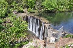
Shady Lake Dam | |
  | |
| Nearest city | Athens, Arkansas |
|---|---|
| Coordinates | 34°21′41″N 94°1′51″W / 34.36139°N 94.03083°WCoordinates: 34°21′41″N 94°1′51″W / 34.36139°N 94.03083°W |
| Area | less than one acre |
| Built | 1940 |
| Architectural style | Rustic |
| MPS | Facilities Constructed by the CCC in Arkansas MPS |
| NRHP Reference # | 93001097[1] |
| Added to NRHP | October 20, 1993 |
Shady Lake Recreation Area is a campground and public recreation area in southwestern Ouachita National Forest, southwest of Mena, Arkansas and west of Glenwood, Arkansas. The area is oriented around Shady Lake, a body of water on the South Fork Saline River impounded by a dam built c. 1940 by the Civilian Conservation Corps (CCC). The area is administered by the United States Forest Service (USFS).
Description
Shady Lake is located in central western Arkansas, on the southern fringe of Ouachita National Forest, about 30 miles (48 km) west of Glenwood. The lake itself is roughly crescent-shaped and was created in 1935 with the assistance of enrollees from the CCC, particularly by members from Company 742 stationed at Camp F-4 (situated within the community of Shady). The dam measures 130 feet (40 m) long and 40 feet (12 m) high across the Saline River.[2] The dam, along with seven other CCC-built structures, is listed on the National Register of Historic Places.[1]
The developed facilities are located on the north side of the lake, and include four camping loops, an swimming area, fishing pier, amphitheater, and other recreational facilities. Comfort facilities consist of 50 camping units including 19 units with water and electricity and one with full hookups, bathroom facilities with warm-water showers, and flush toilets.[3] A central feature of the beach area is its CCC-built bathhouse, a rustic log structure with novelty siding, which includes changing areas at the ends and an open picnic area in the middle.[4] A second CCC-built picnic shelter is located north of the dock.[3][5]
Other CCC-built structures in the recreation area include the diving platform, amphitheater, caretaker's house, and two stone bridges. The first bridge crosses the South Fork on the forest road east of the lake, and is a stone arch structure built over a metal culvert.[6] The second bridge carries part of the campground loop road across East Fork, just north of the lake.[7]
See also
References
- 1 2 National Park Service (2010-07-09). "National Register Information System". National Register of Historic Places. National Park Service.
- ↑ "NRHP nomination for Shady Lake Dam" (PDF). Arkansas Preservation. Retrieved 2015-05-07.
- 1 2 "Shady Lake Recreation Area" (PDF). United States Forest Service. Retrieved 2015-05-07.
- ↑ "NRHP nomination for Shady Lake Bathhouse" (PDF). Arkansas Preservation. Retrieved 2015-05-07.
- ↑ "NRHP nomination for Shady Lake Picnic Pavilion" (PDF). Arkansas Preservation. Retrieved 2015-05-07.
- ↑ "NRHP nomination for Shady Lake Bridge #1" (PDF). Arkansas Preservation. Retrieved 2015-05-07.
- ↑ "NRHP nomination for Shady Lake Bridge #2" (PDF). Arkansas Preservation. Retrieved 2015-05-07.
| Topics | |
|---|---|
| Lists by states |
|
| Lists by insular areas | |
| Lists by associated states | |
| Other areas | |
| |