Shady Grove station
| Washington Metro rapid transit station | |||||||||||
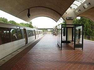 Shady Grove station in September 2004, facing to the south. | |||||||||||
| Location |
15903 Somerville Drive Derwood, MD 20855 | ||||||||||
| Coordinates | 39°7′11.9″N 77°9′53.1″W / 39.119972°N 77.164750°WCoordinates: 39°7′11.9″N 77°9′53.1″W / 39.119972°N 77.164750°W | ||||||||||
| Owned by | WMATA | ||||||||||
| Line(s) |
| ||||||||||
| Platforms | 1 island platform | ||||||||||
| Tracks | 2 | ||||||||||
| Connections |
| ||||||||||
| Construction | |||||||||||
| Structure type | at-grade | ||||||||||
| Parking | 5,467 spaces | ||||||||||
| Bicycle facilities | 32 racks, 60 lockers | ||||||||||
| Disabled access | Yes | ||||||||||
| Other information | |||||||||||
| Station code | A15 | ||||||||||
| History | |||||||||||
| Opened | December 15, 1984 | ||||||||||
| Traffic | |||||||||||
| Passengers (2015) |
12,609 daily [1] | ||||||||||
| Services | |||||||||||
| |||||||||||
Shady Grove is an island platform Washington Metro station in Derwood, Maryland, United States. The station was opened on December 15, 1984, and is operated by the Washington Metropolitan Area Transit Authority (WMATA). Serving as the northwestern terminus of the Red Line, it was the station most distant from downtown Washington until July 26, 2014, when the Silver Line began operations. The station is the location of the Shady Grove Yard, one of the largest storage yards in the Metrorail system.
Location
.jpg)

Despite its name, Shady Grove station is located within the unincorporated community of Derwood; it takes its name from Shady Grove Road to the north. Much of the surrounding area is industrial or low-density residential in nature, although Rockville Road to the south contains strips of commercial activity.[2] To the west is MD 355 (Frederick Road), a continuation of Rockville Pike, which the Red Line parallels throughout much of its route in western Montgomery County; MD 200A connects the Shady Grove station to I-370 and MD 200, better known as the Intercounty Connector. a toll road extending east to I-95. The station is the northernmost station in the Washington Metro system.
Transit-oriented development
In order to cope with increasing population growth and subsequent traffic congestion while combating urban sprawl, the Montgomery County Planning Department released the Shady Grove Sector Plan, which aims to act as a guideline for mixed-use growth around the station. The plan emphasises high-density residential and commercial properties within the immediate vicinity of Shady Grove station, with a steady transition to low-density as the distance from the station increases.[2]
The Sector Plan divides the surrounding area into five districts: Metro North, Metro East, Metro West, Metro South, and Jeremiah Park. Combined, there will be over 6,000 residential units within walking distance of Shady Grove station. In addition, the plan encourages the creation of a walkable street grid with defined main streets integrated with a comprehensive open space and park system.[2]
History
The station opened on December 15, 1984.[3] Its opening coincided with the completion of 7 miles (11 km)[4] of rail northwest of the then named Grosvenor station and the opening of the Rockville, Twinbrook, and White Flint stations.[3] In 1996, this station was the site of the Washington Metro's second fatal accident in which one person was killed.[5] The Washington Post reported that the striking train was two months overdue for scheduled brake maintenance. A degradation of brake performance could have played a role in the crash. The crash, which occurred during the Blizzard of 1996, was caused by a failure in the train's Automatic Train Control system.[6]
Station layout
| P Platform level |
Westbound | ← |
| Island platform, doors will open on the left | ||
| Eastbound | → | |
| M | Mezzanine | One-way faregates, ticket machines, station agent |
| G | Street Level | Exit/ Entrance |
References
- ↑ "Metrorail Average Weekday Passenger Boardings" (PDF). WMATA. Retrieved 2016-06-07.
- 1 2 3 Shady Grove sector plan Montgomery County Planning Retrieved 20 September 2010
- 1 2 Zibart, Eve (December 16, 1984), "A rainbow coalition flocks to Red Line; four stops open amid hoopla", The Washington Post, p. A1
- ↑ Washington Metropolitan Area Transit Authority (July 2009). "Sequence of Metrorail openings" (PDF). Retrieved July 30, 2010.
- ↑ "Railroad Accident Report: Collision of Washington Metropolitan Area Transit Authority Train T-111 with Standing Train at Shady Grove Passenger Station, Gaithersburg, Maryland, January 6, 1996" (PDF). National Transportation Safety Board. 1996-10-29. Retrieved July 30, 2010.
- ↑ Matt Johnson (24 June 2009). "A look at Metro's safety systems". Greater Greater Washington. Retrieved August 2015.
It's far too early to speculate on the cause of the collision at this time. However, those familiar with the system already suspect that something went wrong in Metro's signaling system that allowed these trains to approach and collide.
Check date values in:|access-date=(help)
External links
- WMATA: Shady Grove Station
- StationMasters Online: Shady Grove Station