Shadwell

Coordinates: 51°30′26″N 0°02′48″W / 51.5071°N 0.0466°W
Shadwell is a district in East London, England, in the London Borough of Tower Hamlets, and located on the north bank of the Thames between Wapping and Ratcliff. It is located 3 miles (4.8 km) east of Charing Cross and forms part of the East End of London.
History
Etymology
In the 13th century, the area was known as Scadflet and Shatfliet[2] – derived from the Anglo-Saxon fleot, meaning a shallow creek or bay – the land was a low lying marsh.[3] A spring, issuing from near the south wall of the churchyard was dedicated to St Chad, and filled a nearby well.[4] The origin of the name is therefore confused, being associated with both the earlier use and the later well. Shadwell was formerly called Chadwelle.[5]
Origins


In 1975, archaeologists discovered evidence of a port complex between Ratcliff and Shadwell, that was used throughout Roman occupation of Britain, and being most active in the 3rd century AD. The port seems to have initially been used for seagoing ships into the City of London, which is believed to have stopped between 250 and 270AD. A water level drop meant that the port was used primarily for the public bath house near St George in the East, which existed from the first to fourth centuries.[6] Archaeologists also found evidence of a late third-century signal tower in Shadwell.[7] A Roman cemetery containing two coffins was also discovered in Shadwell in around 1615.[8]:443
16th and 17th centuries
In the sixteenth century, Shadwell was an almost uninhabited hamlet in Stepney, although historian John Stow recalled that elm trees were removed from Shadwell in order to make way for tenements.[9] Eastern Shadwell had been drained in the Middle Ages whilst Western Shadwell had been drained during the reign of King Henry VIII, by Cornelius Vanderdelf after an Act of Parliament.[3][6] This had been caused by an increase in London's maritime activities in the 16th century.[10]:41 In 1650, Shadwell had 703 buildings, Of these houses, 195 were single-storey houses, 473 were two-storey houses, and 33 were three-storey houses, although many were subdivided.[11]:92 The population of Shadwell in 1650 was around 3,500.[12]:130 In the 1660s, a Hearth tax was introduced, although around 50% of residents in Shadwell were deemed too much in poverty to pay the tax.[12]:132
In 1669, Thomas Neale became a local landowner, buying some land reclaimed from the river, and gained Shadwell parish status. In addition, Neale built 289 homes, a mill, and a market, and also established a waterworks on large ponds, left by the draining of the marsh. The area had been virtually uninhabited and he developed the waterfront, with houses behind as a speculation., and in doing so provided fresh water for Shadwell and Wapping.[3][6][13]:148 Shadwell became a maritime hamlet with roperies, tanneries, breweries, wharves, smiths, and numerous taverns, built around the chapel of St Paul's. Seventy-five sea captains are buried in its churchyard; Captain James Cook had his son baptised there. Shadwell's new houses were built in an orderly fashion, so that the streets ran between Ratcliff Highway and Wapping Wall.[11]:91 In 1674, Shadwell had a population of around 8,000.[9] The prosperity in this period has been linked to the road connections into London, which were maintained by wealthy taxpayers from Middlesex, Essex, Kent and Surrey.[10]:332–333
18th and 19th centuries
By the mid-eighteenth century, Shadwell Spa was established, producing sulphurous waters, in Sun Tavern fields. As well as for medicinal purposes, salts were extracted from the waters; and used by local calicoprinters to fix their dyes.[6][14] By the mid-eighteenth century, many houses in Shadwell had been rebuilt. "Seamen, watermen and lightermen, coalheavers and shopkeepers, and ropemakers, coopers, carpenters and smiths, lived in small lathe and plaster or weatherboard houses, two storeys and a garret high, with one room on each floor"; the average rent was £2-7.[6] In 1767, London coal workers who were protesting for higher wages began shooting at the landlord of the Roundabout Tavern in Shadwell; as a result, seven of them were hanged in the Sun Tavern fields. Their execution was witnessed by around 50,000 spectators, the largest crowd at a hanging since the hanging of Laurence Shirley, 4th Earl Ferrers in 1760.[15][16] in 1794, many houses on the Ratcliffe Highway were destroyed by a fire which "consumed more houses than any one conflagration has done since the Great Fire of London", and also destroyed many boats, and around £40,000 of sugar.[8]:443–445
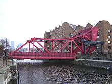
Shadwell Waterworks was sold in 1801 to the London Dock Company; the waterworks were the first ones in London to use a Watt steam engine in 1788. The waterworks were later sold to the East London Waterwork Company for £300,000 in 1808, after an Act of Parliament allowed the company to obtain a compulsory purchase order.[17][18] The modern area is dominated by the enclosed former dock, Shadwell Basin, whose construction destroyed much of the earlier settlement – by this time degenerated into slums.[3] The basin once formed the eastern entrance to the then London Docks, with a channel leading west to St Katharine Docks. It is actually two dock basins - the south basin was constructed in 1828-32 and the north basin in 1854-8. A new entrance to Shadwell dock was opened in 1832, giving Shadwell access to the River Thames.[19][20]:119 Between 1854 and 1858, a 45 feet wide new entrance to the docks was constructed to allow larger ships into the dock.[19] Shadwell Basin was one of three locked basins connecting the docks to the River Thames, and is the only one of the three still in existence today.[21] In 1865, HMS Amazon docked at Shadwell Basin in order to pick up around 800 Mormons who were emigrating to America,[20]:130 and in 1869, the Blue Jacket clipper, then the fastest clipper in the world, began her journey to Canterbury, New Zealand in Shadwell Basin.[22] In 1865 during excavation for the creations of some docks at Shadwell, four nearby houses were flooded.[23] In 1844, Shadwell was recorded as having had a population of 10,060, and having ten almshouses built using money from James Cook.[24]
In the 19th century, Shadwell was home to a large community of foreign South Asian lascar seamen, brought over from British India by the East India Company. There were also Anglo-Indians, from intermarriage and cohabitation between lascar seamen and local girls. There were also smaller communities of Chinese and Greek seamen, who also intermarried and cohabited with locals.[25][26] In 1805, lascars caused disturbances in the streets of Shadwell which ended with 15 people being hospitalised, and 19 people being arrested.[27]
During Victorian times, Shadwell and the East End were not seen as pleasant places. The growth of Shadwell's port led to an increase in the number of prostitutes in the area, and the area was known as the centre of the capital's opium smoking,[28] and in 1861, Shadwell paid a poor rate of 3 s. 9d.[29] An 1889 book The Bitter Cry of Outcast London described Ratcliffe, Shadwell and Bermondsey as a "revolting spectacle", a "dark vision", and a "ghastly reality",[30]:62–63 whilst Charles Dickens' unfinished novel The Mystery of Edwin Drood involves a journey to an opium den in Shadwell, which includes the line "Eastward and still eastward through the stale streets he takes his way, until he reaches his destination: a miserable court, specially miserable amongst many such."[30]:55
In 1885, Shadwell Fish Market was opened as an alternative to Billingsgate Fish Market. Although Shadwell had the advantage of three times the river frontage of Billingsgate and access via train,[lower-alpha 1] the fish market was ultimately unsuccessful.[13]:308 In 1901, it was sold to the City of London Corporation, and was eventually closed in 1914. The site later became King Edward Memorial Park in 1922, when it was opened by King George V, and was Shadwell's first park.[31][32]:429 From 1868-1932, Shadwell was home to the East London Hospital for Children (later the Queen Elizabeth Hospital for Children), before it moved to Wapping, and was later closed down in 1963.[32]:672
20th century
In 1906, the Corporation of London agreed to contribute £500 to the widening of Shadwell High Street to 40 feet (12 m).[33] In 1916, seven women were killed in a sack factory fire; around 50 women were in the building at the time, and the rest escaped. The five-storey warehouse was almost completely destroyed.[34][35][36] In 1934, a 10 lb (4.5 kg) bomb was found four feet below the surface of Shadwell High Street; the bomb was believed to be from the German World War I air raids on the area.[37][38]
In 1936, residents of Shadwell were involved in the Battle of Cable Street, in which Oswald Mosley's attempted fascist march from Tower Hill to Aldgate via Shadwell (which was predominantly Jewish) was stopped by 250,000 protestors blocking their path by overturning a lorry.[39][40] In 1982, a mural was created to commemorate the moment, and was restored in 2011.[41][42] Workers in Shadwell had previously opposed the British Union of Fascists, and in 1937, Shadwell dockers threatened an unofficial strike after local casual dock labourer Cecil Anthony Hiron was nominated as a BUF candidate in the Stepney Council elections in November; Hiron later withdrew his nomination.[43]
In 1969, the Shadwell Docks, along with the other London docks, were closed and purchased by Tower Hamlets Council.[19]:122 During the 1970s, the docks became derelict,[19]:122[44] before being bought by the London Docklands Development Corporation, who built 169 houses and flats by the basin in 1987.[19]:122
In 1987, Shadwell DLR station was opened, which connected Shadwell to Tower Gateway near Fenchurch Street, and later also Bank station from 1991.[45]
Parish church
St. Paul's Shadwell with St. James Ratcliffe, is traditionally known as the Church of Sea Captains. In 1656 the church was established as a Chapel of Ease, from St Dunstan's, at Stepney. In 1669, it was rebuilt as the Parish Church of Shadwell, and it was the last of five parish churches rebuilt after the Restoration. In 1820, it was again rebuilt as a 'Waterloo church'. Captain James Cook was an active parishioner and John Wesley preached in the church from time to time. Isham Randolph of Dungeness, one of Thomas Jefferson's grandfathers and son of William Randolph, was married in St. Paul's church.
Demographics
According to the 2011 census, 15,110 people lived in Shadwell.[46] 52.9% of people were born in the United Kingdom, with the next highest being 20.8% of people being born in Bangladesh. The most common religion in Shadwell is Islam, with 46.7% of people identifying as Muslim, the next highest being 23.7% who identified as Christian.[47]
Notable current and former residents of Shadwell

- Jane Randolph Jefferson (born 9 February 1721) – Mother of Thomas Jefferson
- Frederick Albert Bridge (18 December 1841 – 29 December 1917) - photographer, singer, conductor and choirmaster
- Bob Crow (13 June 1961 – 11 March 2014) – trade union leader
- Norman Giller (18 April 1940 -) — sports historian, author 99 books, born and lived there until 1960
- Mildred Gordon (24 August 1923 -) — Member of Parliament for Bow & Poplar (1987-1997) and teacher at Shadwell's Nicholas Gibson School, born and lived there until 1962
- Walter Pater (4 August 1839 – 30 July 1894) — essayist and critic[48]
- Jah Wobble, lived there from the early 1980s to mid-1990s[49] — musician and writer
Education
Specifically local schools include Blue Gate Fields and Bigland Green Primary schools; and Bishop Challoner Catholic Collegiate School.
Transport and locale
- Nearest places
The nearest London Overground stations are Shadwell and Wapping and the Docklands Light Railway stations at Limehouse and Shadwell.
THCH Hop Festival
In 2006 local Housing Association, Tower Hamlets Community Housing (THCH) built a new block of flats in Shadwell, adjacent to the existing flats at the corner of Cable Street and Devonport Street, called Thirza House. It was opened by Mildred Gordon, a former Shadwell resident and MP for the area from 1987 to 1997. As part of the new development THCH built a hop garden.
Since 2007, THCH have held a Hop Festival every September in the hop garden to commemorate the tradition of generations of East Enders temporarily migrating to Kent's hop gardens to harvest the hops. THCH have produced souvenir booklets containing historical photos of East Enders harvesting hops which are available from Tower Hamlets Community Housing.[50] In 2009 the Shadwell hops were harvested by the local residents and Brodies Brewery in Leyton used them to create a new beer called "Old Hopper's Brew". The beer sold out within a month.[51]
See also
Notes
- ↑ Shadwell & St. George's East railway station had opened in 1840, and Shadwell railway station in 1876.
References
- ↑ "Tower Hamlets Ward population 2011". Neighbourhood Statistics. Office for National Statistics. Retrieved 17 October 2016.
- ↑ Deeds: A.2501 - A.2600, A Descriptive Catalogue of Ancient Deeds: Volume 2 (1894), pp. 87-99 (Middlesex A2589, c. 1218) accessed: 26 August 2008
- 1 2 3 4 Shadwell The Copartnership Herald, Vol. II, no. 23 (Christmas 1932-January 1933)accessed: 26 August 2008
- ↑ Book 5, Ch. 3: Parishes east of the Tower, A New History of London: Including Westminster and Southwark (1773), pp. 769-772 accessed: 26 August 2008
- ↑ "Shadwell".
- 1 2 3 4 5 Cox, Jane (November 2013). Old East Enders: A History of Tower Hamlets. The History Press. Retrieved 21 January 2016.
- ↑ Sheppard, Francis (November 1988). London: A History. OUP Oxford. p. 40. Retrieved 21 January 2016.
- 1 2 Hughson, David (1805). London; Being an Accurate History and Description of the British Metropolis and Its Neighbourhood: To Thirty Miles Extent, from an Actual Perambulation, Volume 4. Retrieved 22 January 2016.
- 1 2 Clark, Peter (2000). The Cambridge Urban History of Britain, Volume 2. Cambridge University Press. pp. 297, 319. Retrieved 21 January 2016.
- 1 2 Bucholz, Robert O.; Ward, Joseph P. (July 2012). London: A Social and Cultural History, 1550–1750. Cambridge University Press. Retrieved 22 January 2016.
- 1 2 Porter, Roy (October 2000). London: A Social History. Penguin. Retrieved 21 January 2016.
- 1 2 Merritt, J.F. (2001). Imagining Early Modern London: Perceptions and Portrayals of the City from Stow to Strype, 1596-1720. Cambridge University Press. Retrieved 22 January 2016.
- 1 2 Richardson, John (July 2001). The Annals of London: A Year-by-year Record of a Thousand Years of History. W&N. Retrieved 22 January 2016.
- ↑ Shadwell, The Environs of London: volume 3: County of Middlesex (1795), pp. 383-390 accessed: 26 August 2008
- ↑ Linebaugh, Peter (March 2006). The London Hanged: Crime and Civil Society in the Eighteenth Century. Verso. p. 321. Retrieved 22 January 2016.
- ↑ Wheatley, Henry Benjamin; Cunningham, Peter (January 2010). London Past and Present: Its History, Associations, and Traditions. Nabu Press. p. 334. Retrieved 21 January 2016.
- ↑ Brayley, Edward Norris; Brewer, James Norris; Nightingale, Joseph (1810). London and Middlesex, or, An historical, commercial, & descriptive survey of the metropolis of Great-Britain. Retrieved 22 January 2016.
- ↑ Cassis, Youssef; De Luca, Giuseppe; Florio, Massimo (January 2016). Infrastructure Finance in Europe: Insights into the History of Water, Transport, and Telecommunications. OUP Oxford. Retrieved 21 January 2016.
- 1 2 3 4 5 Gilbert, Rodney (June 2014). Gold Letters Limp B&W. Rod Gilbert. p. 122. Retrieved 22 January 2016.
- 1 2 Werner, Alex; Williams, Tony (April 2012). Dickens's Victorian London, 1839-1901. Ebury Press. Retrieved 22 January 2016.
- ↑ "London Dock" (PDF). Berkeley Group. Retrieved 22 January 2016.
- ↑ "Steam Communication". Northern Whig. 27 July 1868. Retrieved 15 February 2016 – via British Newspaper Archive. (subscription required (help)).
- ↑ "Untitled". North Devon Journal. 28 September 1865. Retrieved 15 February 2016 – via British Newspaper Archive. (subscription required (help)).
- ↑ Lewis, Samuel (1848). A Topographical Dictionary of England. pp. 51–56. Retrieved 30 May 2016 – via British History Online.
- ↑ Fisher, Michael Herbert (2006), Counterflows to Colonialism: Indian Traveller and Settler in Britain 1600-1857, Orient Blackswan, pp. 106, 111–6, 119–20, 129–35, 140–2, 154–8, 160–8, 172, 181, ISBN 81-7824-154-4
- ↑ Fisher, Michael Herbert (2006), "Working across the Seas: Indian Maritime Labourers in India, Britain, and in Between, 1600–1857", International Review of Social History, 51: 21–45, doi:10.1017/S0020859006002604
- ↑ Behal, Rana P.; van der Linden, Marcel (January 2007). Coolies, Capital and Colonialism: Studies in Indian Labour History. Cambridge University Press. p. 42. Retrieved 21 January 2016.
- ↑ Glinert, Ed (June 2007). Literary London: A Street by Street Exploration of the Capital's Literary Heritage. Penguin. Retrieved 22 January 2016.
- ↑ Grady, Standish Grove (1862). The diminution of the poor rate by improved legislation. pp. 80–81. Retrieved 22 January 2016.
- 1 2 The Cultural Construction of London's East End: Urban Iconography, Modernity and the Spatialisation of Englishness. Rodopi. August 2008. Retrieved 22 January 2016.
- ↑ "Scheme to Construct a Riverside Garden". London Daily News. 31 July 1911. Retrieved 15 February 2016 – via British Newspaper Archive. (subscription required (help)).
- 1 2 Hibbert, Christopher; Weinreb, Ben; Keay, Julia; Keay, John (April 2010). The London Encyclopaedia. Macmillan. Retrieved 21 January 2016.
- ↑ "Rehousing at Shadwell". London Daily News. 17 November 1906. Retrieved 15 February 2016 – via British Newspaper Archive. (subscription required (help)).
- ↑ "Seven Lives Lost". Exeter and Plymouth Gazette. 20 December 1916. Retrieved 15 February 2016 – via British Newspaper Archive. (subscription required (help)).
- ↑ "A London Fire: Seven Lives Lost". Western Times. 20 December 1916. Retrieved 15 February 2016 – via British Newspaper Archive. (subscription required (help)).
- ↑ "Seven Women Burnt To Death". Western Daily Press. 20 December 1916. Retrieved 15 February 2016 – via British Newspaper Archive. (subscription required (help)).
- ↑ "Untitled". Hull Daily Mail. 4 May 1934. Retrieved 15 February 2016 – via British Newspaper Archive. (subscription required (help)).
- ↑ "Untitled". Grantham Journal. 12 May 1934. Retrieved 15 February 2016 – via British Newspaper Archive. (subscription required (help)).
- ↑ Jackson, Sarah; Taylor, Rosemary (July 2014). Voices from History: East London Suffragettes. The History Press. Retrieved 21 January 2016.
- ↑ "Lorry Overturned". Sheffield Independent. 5 October 1936. Retrieved 15 February 2016 – via British Newspaper Archive. (subscription required (help)).
- ↑ "The Battle of Cable Street".
- ↑ "Cable Street: 'Solidarity stopped Mosley's fascists'". BBC News.
- ↑ Linehan, Thomas P. (December 1996). East London for Mosley: British Union of Fascists. Routledge. pp. 88–89. Retrieved 21 January 2016.
- ↑ Edwards, Brian C. (December 1992). London Docklands: Urban Design in an Age of Deregulation. Butterworth-Heinemann. p. 18. Retrieved 22 January 2016.
- ↑ Gayler, Hugh J. (1996). Geographical Excursions in London. University Press of America. p. 133. Retrieved 22 January 2016.
- ↑ http://www.ukcensusdata.com/shadwell-e05000586#sthash.Qt0byDiz.dpbs
- ↑ http://shadwell.localstats.co.uk/census-demographics/england/london/tower-hamlets/shadwell
- ↑ Seiler, Robert M. (1970). The Book Beautiful: Walter Pater and the House of Macmillan. Continuum International Publishing Group Ltd. p. 1. Retrieved 22 January 2016.
- ↑ Jah Wobble, Memoirs of a Geezer, p. 161-2.
- ↑ Tower Hamlets Community Housing's newsletter "Update" - published October 2009
- ↑ http://www.theguardian.com/society/2010/sep/22/east-london-local-beer
| Wikimedia Commons has media related to Shadwell, London. |
