Shadow Hills, Los Angeles
| Shadow Hills | |
|---|---|
| Neighborhood of Los Angeles | |
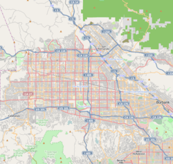 Shadow Hills Location within Los Angeles/San Fernando Valley | |
| Coordinates: 34°15′43″N 118°21′03″W / 34.26194°N 118.35083°W | |
| Country | United States |
| State | California |
| County | Los Angeles |
| City | Los Angeles |
| Time zone | PST (UTC-8) |
| • Summer (DST) | PDT (UTC-7) |
| ZIP code | 91040 |
Shadow Hills is a semi-rural neighborhood in the Verdugo Mountains and northeastern San Fernando Valley, within the city of Los Angeles, California.
History
Shadow Hills is located in the southern portion of the community of Sunland and extreme northeast portion of the community of Sun Valley that is east of Glenoaks Boulevard.
The City of Los Angeles annexed Sunland in June 1926. For many years, Shadow Hills remained rural and largely undeveloped because its hills and "rock-hard" soil made it difficult to build.[1]
The area is primarily equestrian zoned, one of the last remaining such sections within the City of Los Angeles.
Geography
The community of Shadow Hills is located in the northwestern Verdugo Mountains, near the western end of the Crescenta Valley. It is north of the city of Burbank and southeast of the Hansen Dam Reservoir.
Shadow Hills is adjacent to the communities of Lake View Terrace to the north, Sunland and Tujunga to the east, Sun Valley to the south, and Pacoima to the west.
Shadow Hills is an acceptable city name for ZIP Code 91040, with Sunland the default city name assigned to 91040.[2]
Demographics
As of the 2000 census, Shadow Hills has a population of 3,739 people.[3] The racial breakdown includes 79% Caucasian, 14% Latino, 3% Asian American, and 1% African American.[4]
Shadow Hills falls within Census Tract 103300.
In 2009, the Los Angeles Times's "Mapping L.A." project supplied these Shadow Hills neighborhood statistics: population: 13,098; median household income: $82,796.[5]
Government
Shadow Hills is within the City of Los Angeles and is represented by:
- Los Angeles City Council District 7, Councilmember Felipe Fuentes.[6]
- Los Angeles County Board of Supervisors District 5, Supervisor Michael D. Antonovich
- California State Senate District 25, Anthony Portantino[7]
- California State Assembly District 39, Raul Bocanegra[7]
- United States House of Representative District 28, Adam Schiff[8]
Public safety
- Los Angeles Fire Department Station 24 (Sunland/Shadow Hills) is in the area.[9]
- Los Angeles Fire Department Station 77 (Sun Valley/Shadow Hills/La Tuna Canyon) is in the area.[10]
- Shadow Hills is served by the Los Angeles Police Department Foothill Community Police Station.[11]
Education
The Los Angeles Unified School District (LAUSD) serves Shadow Hills.
Property Owners Association
The neighborhood's residents formed the Shadow Hills Property Owners Association in the mid-1960s to fight the planned routing of a Foothill Freeway offramp through the heart of the neighborhood. This would have run along McBroom Street and two segments of Wheatland Avenue, from Wentworth Avenue to Sunland Boulevard. This organization persuaded the Los Angeles Planning Commission to abandon the proposed route for the offramp, and so preserved the neighborhood's semi-rural character. The Association continues to function today.[12]
Notable residents
- Mark Salling[13]
- Jordon Terrell
References
- ↑ http://web.archive.org/web/20051111031000/http://www.lacity.org/council/cd2/doc/Community_Descriptions.pdf
- ↑ "ZIP Code Lookup tool". United States Postal Service. Retrieved 2007-03-18.
- ↑ "City of Los Angeles Population by Community & Race". Los Angeles Almanac. Retrieved 2007-03-18.
- ↑ http://www.laalmanac.com/population/po24la.htm
- ↑ "Shadow Hills" entry on the Los Angeles Times "Mapping L.A." website
- ↑ Welcome to LA Council District 7
- 1 2 "Statewide Database". UC Regents. Retrieved December 10, 2014.
- ↑ "California's 28th Congressional District - Representatives & District Map". Civic Impulse, LLC.
- ↑ http://www.lafd.org/fs24.htm
- ↑ http://www.lafd.org/fs77.htm
- ↑ http://www.lapdonline.org/foothill_community_police_station
- ↑ Shadow Hills Property Owners Association
- ↑ "Ex-'Glee' star Mark Salling indicted on child-porn charges." Houston Chronicle. Saturday, May 28, 2016. Retrieved on May 28, 2016.
External links
- Shadow Hills Property Owners Association
- Sunland-Tujunga Chamber of Commerce
- Sun Valley Area Chamber of Commerce
- Sunland-Tujunga Neighborhood Council
Coordinates: 34°15′43″N 118°21′03″W / 34.26194°N 118.35083°W
| Topics |  | |
|---|---|---|
| Government | ||
| Districts and neighborhoods |
|  |
|---|---|---|
| Points of interest | ||
| Neighboring cities and communities | ||