Shabaran
Shabran (Shabaran, Shavaran, Sabaran) (Azerbaijani: Şabran) – was a historical town and district which existed from the 5th to the 18th centuries. It was in what is now the eastern part of the Azerbaijani Republic, within the borders of Greater Caucasus pass, located between Baku and Quba.[1] It was completely destroyed in 1723.[2]
Etymology
There are several versions about origin of Shabran city and oblast. According to one of them, the city allegedly was founded by Shapur I, the Shah of the Sassanids, and the name of the city is originated from Shapuran, Pahlavi form of his name. The given version is not considered verisimilar, as if origination of the city is dated back to 5th-7th centuries AD, but Shapur I lived three centuries earlier. Another version connects the name of the city with Savar/Sabar tribe. There is not an accurate version about the name’s origin, yet.
History

Shabran appeared in the 5th-7th centuries as a fortress-city, but by the 9th-10th centuries became the great political-administrative, trade-handicraft and cultural center of the Shirvanshahs Government. In the mid 11th century, the family burial vault of the Shirvanshahs was in Shabran. Subsequently, the name of the city was given to surrounding area.
In the mid 13th century, the city was invaded by the Mongols and was partly destroyed. The city was revived in the late 13th and early 14th centuries and continued till the end of the 15th century.
But as a result of the Ottoman–Persian Wars in the first quarter of the 18th century, the city was heavily damaged and lost its significance.[3][4] The conclusive collapse of the city however, is related to an earthquake, which wiped the city off the face of the Earth. The remaining population of the city was subsequently resettled to one of remote "suburbs", i.e. the caravanserais belonging to Shabran, around which Davachi city originated and which was renamed to Shabran in 2010.
Mentions of the city
Name of the city in form of “Shaberan” was met in a manuscript of “Kitabi dede Korkut” epos of Oghuzs of the 16th century, kept in Dresden.[5]
Turkish traveler Evliya Çelebi was in Shabran in 1647 and wrote: “…In Persia it is considered the second city after Tabriz .There are seventy quarters and palatial mosques of Uzun Hassan in the city. Walls of the mosque are decorated with delicate ornaments overtopped as chameleon’s skin, and carving on marble amazed experts on architectural arts.” [6] According to testimonies of A.A.Bakhikhanov, Tabasarans captured the territory belonged to Shabran, during the reign of Turks (late 16th-early 17th centuries). Turks, didn’t demand to return it, despite they needed it. It should be mentioned that Tabasarans captured a significant territory, because “possessing this point, they impeded messaging between Derbent and Shabran”. Population of Shabran consisted of Muslim, Jew and Christian communities, and Muslim community was dominated among them.
Architecture
A.A.Bakikhanov was the first who said his opinion about that reuins near Shahnazarli village of Shabran Rayon belong to Shabran city of the Middle Ages (since then it was considered the ruins of Gulustani-Irem city).
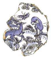
In the result of archeological excavations in the territory of the city, in 1979-1989, was opened an area with a size of more than 4500 km2. Width of deposition of remains of material culture reached 5 meters. A fortress belonging to the 10th century was dug out. Scientists determined that it was constructed for defensive aims. Walls of the fortress were consolidated with semicircular towers. Limestone, pebble and burned bricks were used in construction of the fortress. The fortress existed until the mid 13th century. In the 14th century, a small castle-tower was constructed in the western part of the demolished fortress. It had a rectangular shape and remained of Absheron fortresses. Architects used mixed layings in its construction. Excavations are evidence of quarterly planning of the city. Houses here were constructed of burned brick, on a peddle foundation. There was a water supply system in the city. Economy of the city was based on a handicraft production. In the result of archeological excavations, a ceramic set of ten items was found out. A ceramic workshop was found out under the ruins of the city. Blacksmith’s, foundry, copper, jewelry and weapon production, and production of glass were also existed in the city.[7]
References
- ↑ Nasiri, Ali Naqi; Floor, Willem M. (2008). Titles and Emoluments in Safavid Iran: A Third Manual of Safavid Administration. Mage Publishers. p. 278. ISBN 978-1933823232.
- ↑ Nasiri, Ali Naqi; Floor, Willem M. (2008). Titles and Emoluments in Safavid Iran: A Third Manual of Safavid Administration. Mage Publishers. p. 278. ISBN 978-1933823232.
- ↑ NaVoprosOtveta.Net
- ↑ Средневековый город ШАБРАН
- ↑ Translator Vasily Bartold (1962). КНИГА ДЕДА КОРКУТА. Moscow, Saint-Petersburg: National Academy of Sciences of the Azerbaijan SSR.
- ↑ IRS - Международный журнал
- ↑ Карабах в документах
Coordinates: 41°17′44″N 48°52′53″E / 41.29556°N 48.88139°E