Serra de la Fatarella
| Serra de la Fatarella | |
|---|---|
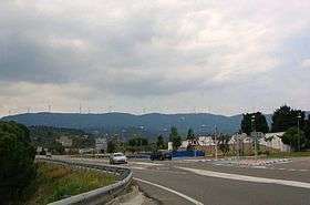 Serra de la Fatarella range rising west of Ascó | |
| Highest point | |
| Elevation | 563.5 m (1,849 ft) |
| Coordinates | 41°11′49.34″N 0°29′42.86″E / 41.1970389°N 0.4952389°ECoordinates: 41°11′49.34″N 0°29′42.86″E / 41.1970389°N 0.4952389°E |
| Geography | |
| Location |
Ribera d'Ebre & Terra Alta (Catalonia) |
| Parent range | Catalan Central Depression |
| Geology | |
| Orogeny | Alpine orogeny |
| Type of rock | Limestone |
| Climbing | |
| Easiest route | Drive from La Fatarella |
Serra de la Fatarella is one of the isolated mountain ranges of the Catalan Central Depression located off the southern end of the Catalan Pre-Coastal Range between La Fatarella and Ascó in Spain.[1] The ridge's highest point is 563.5 m; another important summit is 552 m high Punta de l'Home. This smooth range runs in a N - S direction.
The 18th century renaissance style Ermita de la Misericòrdia is located on a 526 m high summit of the range. It has been reconstructed recently.[2]
History
These mountains, along with Serra de Pàndols further west and Serra de Cavalls in the south, were the scenario of bloody battles during the Battle of the Ebro in the Spanish Civil War (1936–39). The Ebro Battle was also the last action of the International Brigades, who were withdrawn midway through it.[3]
Wind turbines have been built on top of the Serra de la Fatarella ridge.[4]
See also
References
- ↑ "Mapa Topogràfic de Catalunya". Institut Cartogràfic de Catalunya. Retrieved 9- IX - 2010. Check date values in:
|access-date=(help) - ↑ La Fatarella rehabilitarà l'ermita de la Misericòrdia amb el finançament de la Diputació, el Bisbat i l'Ajuntament
- ↑ The Battle of the Ebro in one day
- ↑ Diari de Tarragona - En construcció quatre parcs eòlics més a l’altiplà de la Terra Alta
External links
- Map of the area
- Terra Alta Turismo Rural de Montaña
- La Batalla de l'Ebre
- La Fatarella Town Hall, Tourism
- Tourism - La Fatarella