Serra da Cangalha
Serra da Cangalha is an impact crater in the State of Tocantins, near the border of Maranhão State, in northeastern Brazil.[1]
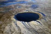
The crater is between 12 and 13 km in diameter, making it the second-largest known crater in Brazil.[2] Its age is estimated to be about 220 million years (Triassic period).[3] The name means Pack-Saddle Mountains in Portuguese.
Description
The outer perimeter is a circular inward scarp about 12 km in diameter on the largely undisturbed Cretaceous and upper Silurian sediments of the Parnaíba basin, breached on the west, north, and south sides by drainage valleys. Within the perimeter there is a series of concentric circular valleys and a central basin, all at roughly the same elevation, separated by ring walls. Shuttle Radar Topography Mission imagery shows a faint ring about 11 km in diameter, a second ring of gentle hills about 5–6 km in diameter, and an inner ring of steeper hills, about 3 km in diameter and up to 420 m high, open to the northwest, surrounding a central basin about 2.2 km in diameter.[4][5][6]
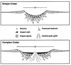
The impact origin is attested by the presence of impact breccias, quartzite shatter cones and shocked quartz. The meteorite is believed to have struck the surface at a low oblique angle, 25 to 30 degrees on dry land. Radial faults are present inside the crater, and some extend up to 16 km from the center.[6] Disturbed and steeply inclined sediments from the Carboniferous and Devonian periods occur within the crater. A magnetic survey of the structure indicates that deformation within the crater extends to a depth of about 2 km.[3][4][5][7][8]
History and studies
The identification of the structure as an impact crater was first published in 1973 by R.S. Dietz and B.M. French.[9][10] Shatter cones were reported by Beatty in 1980.[11] Impact breccias, impact melting, and shocked quartz were reported by McHone in his 1986 thesis.[12] A magnetic survey of the structure was published by A.A. Adepelumi and others in 2005.[5]
References
- ↑ "Serra da Cangalha". Earth Impact Database. University of New Brunswick. Retrieved 2009-08-16.
- ↑ McHone, J F.; Dietz, R S. (1992). "Earth's multiple impact craters and astroblemes (abstract)". XXIII Lunar and Planetary Science. Houston: Lunar and Planetary Institute. pp. 887–888.
- 1 2 R. Almeida Filho; F.R. Moreira; C.H.Beisl (2003). "The Serra da Cangalha astrobleme as revealed by ASTER and SRTM orbital data" (PDF). International Journal of Remote Sensing. 24: 1–6. Retrieved 2007-09-24.
- 1 2 R. Gregio. "Cratera da Serra da Cangalha". Retrieved 2007-09-24.
- 1 2 3 Adepelumi, A. A.; Fontes, S.L.; Schnegg, P.A.; Flexor,J.M. (2005). "An integrated magnetotelluric and aeromagnetic investigation of the Serra da Cangalha impact crater, Brazil". Physics of the Earth and Planetary Interiors. 150 (1): 159–182. Bibcode:2005PEPI..150..159A. doi:10.1016/j.pepi.2004.08.029.
- 1 2 W.U. Reimold; G.R.J. Cooper; R. Romano; D. Cowan; C. Koeberl (2004). "A SRTM Investigation of Serra da Cangalho [sic] Impact Structure, Brazil" (PDF). Lunar and Planetary Science XXXV. Retrieved 2007-09-24.
- ↑ W. Masero; P.-A. Schnegg; S.L. Fontes. "Magnetotelluric investigation of the Serra da Cangalha impact crater, Northeast Brazil". Cite uses deprecated parameter
|coauthors=(help) - ↑ Adekunle Adepelumi; Jean M. Flexor; Sergio L. Fontes; Pierre-A. Schnegg. A magnetotelluric investigation of the Serra da Cangalha impact crater structure, Brazil. Cite uses deprecated parameter
|coauthors=(help) - ↑ Dietz, R.S.; French, B.M. (1973). "Two probable astroblemes in Brazil". Nature. 244 (5418): 561–562. Bibcode:1973Natur.244..561D. doi:10.1038/244561a0.
- ↑ Crósta, A. P. (1987). J. Pohl, ed. "Impact structures in Brazil". Research in Terrestrial Impact Structures. Braunschweig/Wiesbad: Friedrich, Vieweg & Sohn: 30–38.
- ↑ Beatty J. K. (1980). "Crater hunting in Brazil". Sky and Telescope. 59: 464––467. Bibcode:1980S&T....59..464B.
- ↑ McHone J. F. (1986). Terrestrial impact structures: Their detection and verification with new examples from Brazil. University of Illinois at Urbana-Champaign, Urbana, Illinois. p. 210.
Coordinates: 8°5′S 46°52′W / 8.083°S 46.867°W