Senja
 Senja / Sážžá | |
| Geography | |
|---|---|
| Location | Northern Norway |
| Coordinates | 69°20′N 17°30′E / 69.333°N 17.500°ECoordinates: 69°20′N 17°30′E / 69.333°N 17.500°E |
| Area | 1,586.3 km2 (612.5 sq mi)[1] |
| Highest elevation | 1,017 m (3,337 ft) |
| Highest point | Breidtinden |
| Administration | |
|
Norway | |
| County | Troms |
| Municipalities | Berg, Lenvik, Torsken, Tranøy |
| Largest settlement | Silsand, Lenvik (pop. 1535) |
| Demographics | |
| Population | 7808 (2015) |
| Pop. density | 4.9 /km2 (12.7 /sq mi) |
Senja (Northern Sami: Sážžá) is the second largest island in Norway (not counting Svalbard).
The name
The Norse form of the name must also have been *Senja, or perhaps *Sændja. The meaning of the name is unknown, but it might be related to the verb sundra 'tear, split apart': The west coast of the island is torn and split by numerous small fjords. It might also be derived from a Proto-Norse form *Sandijōn meaning '(area) of sand, sandy island'.[2]
Geography

Senja is located along the Troms county coastline with Finnsnes as the closest town. Senja is connected to the mainland by the Gisund Bridge. The municipalities located on Senja are Lenvik (part of which is on the mainland), Berg, Torsken, and Tranøy. Senja had 7782 inhabitants as of 1 January 2008.
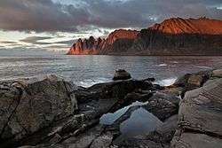
The northern coasts of Senja faces the open sea, the western coast faces Andøya and Krøttøya, the southern coast faces Andørja and Dyrøya. Here, on the western coast, steep and rugged mountains rise straight from the sea, with some fishing villages (like Gryllefjord, Husøy) wherever there is some lowland. The eastern and southern parts of the island are milder, with rounder mountains, forests, rivers and agriculture land.
Senja is often referred to as "Norway in miniature", as the island's diverse scenery reflects almost the entire span of Norwegian nature. Senja is well known domestically for its beautiful scenery, and is marketed as a tourist attraction.
Attractions
Among the sights of the island are Ånderdalen National Park with coastal pine forests and mountains,[3] traditional fishing communities, and the "Troll of Senja" (Norwegian: Senjatrollet)--the world's largest troll. The southernmost municipality Tranøy also has several small museums documenting local history, among these the Halibut Museum ("Kveitmuseet") in Skrolsvik.
Climate
Climate data from Gibostad village on the eastern side of the island, facing the mainland (base period 1961-90). The western side of the island, facing the Norwegian Sea, will have slightly milder but more windy winters.
| Climate data for Gibostad, Lenvik | |||||||||||||
|---|---|---|---|---|---|---|---|---|---|---|---|---|---|
| Month | Jan | Feb | Mar | Apr | May | Jun | Jul | Aug | Sep | Oct | Nov | Dec | Year |
| Average high °C (°F) | −1.9 (28.6) |
−1.8 (28.8) |
0.2 (32.4) |
3.6 (38.5) |
8.4 (47.1) |
12.9 (55.2) |
15.0 (59) |
14.6 (58.3) |
10.5 (50.9) |
5.8 (42.4) |
1.5 (34.7) |
−0.7 (30.7) |
5.7 (42.3) |
| Daily mean °C (°F) | −4.4 (24.1) |
−4.2 (24.4) |
−2.3 (27.9) |
1.0 (33.8) |
5.5 (41.9) |
9.7 (49.5) |
12.3 (54.1) |
11.6 (52.9) |
7.5 (45.5) |
3.3 (37.9) |
−0.8 (30.6) |
−3.2 (26.2) |
3.0 (37.4) |
| Average low °C (°F) | −7.1 (19.2) |
−7.0 (19.4) |
−5.5 (22.1) |
−2.1 (28.2) |
2.5 (36.5) |
6.8 (44.2) |
9.1 (48.4) |
8.3 (46.9) |
5.1 (41.2) |
1.3 (34.3) |
−3.1 (26.4) |
−5.8 (21.6) |
0.2 (32.4) |
| Average precipitation mm (inches) | 85 (3.35) |
80 (3.15) |
60 (2.36) |
54 (2.13) |
39 (1.54) |
47 (1.85) |
62 (2.44) |
71 (2.8) |
91 (3.58) |
119 (4.69) |
94 (3.7) |
98 (3.86) |
900 (35.43) |
| Average precipitation days (≥ 1 mm) | 13.4 | 12.4 | 11.5 | 10.7 | 9.2 | 10.6 | 13.2 | 12.4 | 14.3 | 16.0 | 14.7 | 15.6 | 154.0 |
| Source: Norwegian Meteorological Institute[4] | |||||||||||||
In Popular culture
Senja is mentioned in David Armine Howarth's World War II novel We Die Alone: A WWII Epic of Escape and Endurance. It has a namesake island in the MMORPG Tibia.
Norwegian musician Moddi comes from the island and his music is said to have been influenced by its beauty.[5]
Gallery
- Senja
 Husøy, Northern Senja
 View from a ridge between Segla and Hesten, Senja, Norway,
.jpg) Seashore on the Senja island in Norway
Seashore on the Senja island in Norway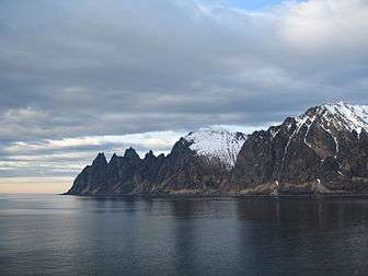 Ersfjorden and near mountains
References
- ↑ Statens kartverk. "Øyer i Norge - største i hvert fylke" (Excel) (in Norwegian).
- ↑ "Bidrag till Fennoskandiens språkliga förhistoria i tid och rum" (PDF) (in Swedish). Helsingfors Universitet. Retrieved 2015-12-27.
- ↑ "Ånderdalen National Park" (in Norwegian). Directorate for nature management. Retrieved 2010-04-04.
- ↑ "eKlima Web Portal". Norwegian Meteorological Institute.
- ↑ "Moddi". Propeller Recordings. Retrieved 2013-01-03.
External links
 Media related to Senja at Wikimedia Commons
 Senja travel guide from Wikivoyage
- Alpin moro på eventyrøya Senja