Seconsett Island, Massachusetts
| Seconsett Island, Massachusetts | |
|---|---|
| Census-designated place | |
|
Seconsett Island | |
| Coordinates: 41°34′0″N 70°30′43″W / 41.56667°N 70.51194°WCoordinates: 41°34′0″N 70°30′43″W / 41.56667°N 70.51194°W | |
| Country | United States |
| State | Massachusetts |
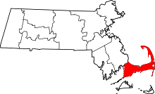
| County | Barnstable |
| Town | Mashpee |
| Area | |
| • Total | 0.11 sq mi (0.28 km2) |
| • Land | 0.10 sq mi (0.27 km2) |
| • Water | 0.004 sq mi (0.01 km2) |
| Elevation | 16 ft (5 m) |
| Population (2010) | |
| • Total | 100 |
| • Density | 972/sq mi (375.3/km2) |
| Time zone | Eastern (EST) (UTC-5) |
| • Summer (DST) | EDT (UTC-4) |
| FIPS code | 25-60627 |
| GNIS feature ID | 1877301 |
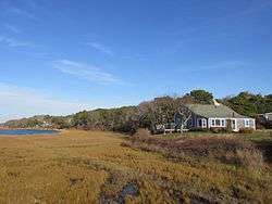
Seconsett Island is a census-designated place (CDP) in the town of Mashpee in Barnstable County, Massachusetts, United States. The population was 100 at the 2010 census.[1]
Geography
Seconsett Island is located in the southwest part of the town of Mashpee at 41°34′0″N 70°30′43″W / 41.56667°N 70.51194°W (41.566734, -70.511950).[2] It is bounded by the town of Falmouth to the northwest, by Hamblin Pond to the northeast, by the Little River to the southeast (with the Monomoscoy Island CDP on the opposite bank), and by Waquoit Bay to the southwest. The only road access is via Meadow Neck Road from Falmouth.
According to the United States Census Bureau, the CDP has a total area of 0.11 square miles (0.28 km2), of which 0.004 square miles (0.01 km2), or 4.53%, is water.[1]
Demographics
As of the census[3] of 2000, there were 81 people, 43 households, and 23 families residing in the CDP. The population density was 284.3/km² (749.7/mi²). There were 141 housing units at an average density of 494.9/km² (1,305.0/mi²). The racial makeup of the CDP was 100.00% White.
There were 43 households out of which 9.3% had children under the age of 18 living with them, 39.5% were married couples living together, 9.3% had a female householder with no husband present, and 46.5% were non-families. 34.9% of all households were made up of individuals and 25.6% had someone living alone who was 65 years of age or older. The average household size was 1.88 and the average family size was 2.39.
In the CDP the population was spread out with 13.6% under the age of 18, 3.7% from 18 to 24, 19.8% from 25 to 44, 29.6% from 45 to 64, and 33.3% who were 65 years of age or older. The median age was 50 years. For every 100 females there were 80.0 males. For every 100 females age 18 and over, there were 94.4 males.
The median income for a household on the CDP was $17,250, and the median income for a family is $0. Males had a median income of $21,250 versus $16,250 for females. The per capita income for the CDP was $15,833. None of the population was below the poverty line.
References
- 1 2 "Geographic Identifiers: 2010 Demographic Profile Data (G001): Seconsett Island CDP, Massachusetts". U.S. Census Bureau, American Factfinder. Retrieved December 11, 2013.
- ↑ "US Gazetteer files: 2010, 2000, and 1990". United States Census Bureau. 2011-02-12. Retrieved 2011-04-23.
- ↑ "American FactFinder". United States Census Bureau. Retrieved 2008-01-31.