Washington State Route 525
| ||||
|---|---|---|---|---|
|
SR 525 is highlighted in red. | ||||
| Route information | ||||
| Auxiliary route of I‑5 | ||||
| Defined by RCW 47.17.735 | ||||
| Maintained by WSDOT | ||||
| Length: |
30.68 mi[1] (49.37 km) Mileage does not include ferry route | |||
| Existed: | 1964[2] – present | |||
| Major junctions | ||||
| South end: |
| |||
|
| ||||
| North end: |
| |||
| Location | ||||
| Counties: | Snohomish, Island | |||
| Highway system | ||||
| ||||

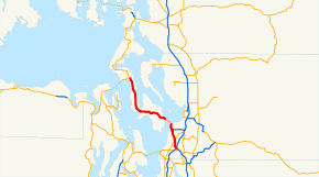
State Route 525 (SR 525) is a 30.68-mile-long (49.37 km) state highway located in Snohomish and Island counties in the western region of the U.S. state of Washington. SR 525 begins at an interchange with Interstate 5 (I-5) and I-405 in Lynnwood and travels north to SR 99 as a four-lane controlled-access freeway. From Lynnwood, the highway serves Mukilteo and becomes the terminus of SR 526 before taking its ferry route to Clinton on Whidbey Island. SR 525 traverses the island's interior as part of the Whidbey Island Scenic Byway before the designation ends at an intersection with SR 20 south of Coupeville.
SR 525 was established during the 1964 state highway renumbering as the successor to Secondary State Highway 1D (SSH 1D) on Whidbey Island and SSH 1I in Mukilteo and Lynnwood, themselves established in 1937. The highway, at its codification in 1970, traversed the north–south length of Whidbey Island and ended at SR 536 near Anacortes until it was replaced by SR 20 in 1973. SR 525 was converted to its present freeway in Lynnwood during the 1980s and widened to four lanes during the late 1990s, including an overpass over SR 99. The highway also has a spur route in Mukilteo that has connected SR 525 to SR 526 via Paine Field Boulevard since it was signed in 2001.
Route description
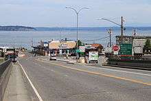
SR 525 begins at the Swamp Creek Interchange with I-5, also serving as the northern terminus of I-405, located in Lynnwood in southern Snohomish County.[3][4] The four-lane controlled-access freeway travels north past Alderwood Mall and a partial cloverleaf interchange with Alderwood Mall Parkway, which serves the eponymous mall.[5] SR 525 continues north under overpasses carrying 164th Street and 148th Street before reaching its partial cloverleaf interchange with SR 99, where the freeway ends.[6] The highway becomes the four-lane Mukilteo Speedway and travels northwest into the city of Mukilteo, serving its commercial and industrial areas located south of Paine Field. SR 525 intersects its spur route, which travels north as Paine Field Boulevard towards the Boeing Everett Factory, before it serves as the western terminus of SR 526. The highway gains a ferry holding lane on its northbound shoulder as it approaches the Mukilteo ferry terminal, located between the Mukilteo Lighthouse Park and the local train station, where the designation of SR 525 is carried onto the Whidbey Island Ferry across Possession Sound. The ferry, operated by Washington State Ferries (WSF), takes approximately 20 minutes for each of its 39 daily round-trip crossings.[7] As of May 2012, WSF charges a fare of $4.65 per walk-on passenger and $7.85 per vehicle during off-peak seasons, with varying fares depending on passenger age and vehicle size.[8] SR 525 leaves the ferry terminal at Clinton and travels west through the interior of Whidbey Island in unincorporated Island County as part of the Whidbey Island Scenic Byway, a state scenic byway.[9][10] The highway turns north along Holmes Harbor in Freeland and continues through Greenbank before SR 525 terminates at SR 20 south of Coupeville.[11][12]
Every year, the Washington State Department of Transportation (WSDOT) conducts a series of surveys on its highways in the state to measure traffic volume. This is expressed in terms of average annual daily traffic (AADT), which is a measure of traffic volume for any average day of the year. In 2012, WSDOT calculated that the busiest section of SR 525 was its southern terminus at I-5 and I-405, serving 61,000 vehicles, while the least busiest section of the highway was at the Mukilteo ferry terminal, serving 5,700 vehicles.[13] SR 525 is designated as part of the National Highway System from Lynnwood to the Mukilteo ferry terminal,[14] classifying it as important to the national economy, defense, and mobility.[15] WSDOT designates the entire route of SR 525 as a Highway of Statewide Significance,[16] which includes highways that connect major communities in the state of Washington.[17]
History
SR 525 uses the Whidbey Island Ferry between Mukilteo and Clinton, which began as a route of the Island Transportation Company in 1919. The ferry was later taken over by the Puget Sound Navigation Company, who were sold to the state of Washington in 1951 during the formation of the WSF.[18][19][20] The discontinuous road sections of SR 525 were added to the state highway system in 1937 as SSH 1D and SSH 1I, both branches of PSH 1.[21] SSH 1D traveled 54.73 miles (88.08 km) on Whidbey and Fidalgo islands from the Clinton ferry dock to an intersection with the Anacortes branch of PSH 1 at Sharps Corner.[22][23] SSH 1I traveled 10.63 miles (17.11 km) in a circular arc from Everett to Lynnwood, traveling on Mukilteo Boulevard and the Mukilteo Speedway.[22][23]
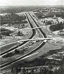
SR 525 was established during the 1964 state highway renumbering and codified in 1970 as the successor to both SSH 1D and SSH 1I,[2][24] traveling 62.04 miles (99.84 km) north from the newly constructed Swamp Creek Interchange at I-5 and I-405 in Lynnwood, opened in 1965,[25][26] to SR 536 south of Anacortes.[27][28][29] The highway was truncated to its present terminus south of Coupeville after SR 20 was extended east as the North Cascades Highway in 1973.[2] SR 525 was re-aligned onto a two-lane freeway within Lynnwood in the 1980s replacing the local streets it had used to connect to I-5 and SR 99. The Swamp Creek Interchange, where SR 525 meets I-5 and I-405, was opened in November 1984.[30]
WSF ferry routes were added to its respective state highways in 1994,[2] eliminating one of two gaps along the route of SR 525, the other being a concurrency with SR 99 that was replaced by a partial cloverleaf interchange in 2000 during the widening of the freeway segment in Lynnwood.[31] A spur route, located completely in Mukilteo, was added to SR 525 in 2001 along the route of the four-lane Paine Field Boulevard, connecting the main highway to SR 526.[2]
Major intersections
| County | Location | mi[1] | km | Destinations | Notes | ||
|---|---|---|---|---|---|---|---|
| Snohomish | Lynnwood | 0.00 | 0.00 | Southern terminus, continues as I-405, southbound exit to I-5 southbound and I-405 southbound only; I-5 north exit 182. | |||
| 0.64 | 1.03 | Alderwood Mall Parkway | |||||
| 2.76 | 4.44 | Access to SR 99 via Lincoln Way | |||||
| North end of freeway | |||||||
| Mukilteo | 5.77 | 9.29 | |||||
| 6.68 | 10.75 | ||||||
| Puget Sound | 8.64– 8.65 | 13.90– 13.92 | Mileage does not include ferry | ||||
| Island | | 30.68 | 49.37 | Northern terminus | |||
| 1.000 mi = 1.609 km; 1.000 km = 0.621 mi | |||||||
Spur route
| |
|---|---|
| Location: | Mukilteo, Washington |
| Length: | 0.86 mi[1] (1.38 km) |
| Existed: | 2001–present[2] |
SR 525 has a 0.86-mile-long (1.38 km) spur route on Paine Field Boulevard in Mukilteo that connects the northbound lanes of the Mukilteo Speedway to SR 526 eastbound towards Everett and the local Boeing factory.[1] Paine Field Boulevard was built in 1999 and signed as SR 525 Spur in 2001,[2] subsequently being widened and improved in 2003 by WSDOT. A proposal to extend Paine Field Boulevard through Japanese Gulch and create a bypass of the Mukilteo ferry terminal has been a part of the city's transportation plan since 2001, but has not been built.[32] WSDOT estimated, during its annual AADT survey, that 21,000 vehicles used the highway in 2012.[13]
References
- 1 2 3 4 Staff (2012). "State Highway Log: Planning Report 2012, SR 2 to SR 971" (PDF). Washington State Department of Transportation. pp. 1638–1650. Retrieved April 22, 2013.
- 1 2 3 4 5 6 7 "47.17.735: State route No. 525". Revised Code of Washington. Washington State Legislature. 1970; revised 1973, 1994, 2001. Retrieved April 22, 2013. Check date values in:
|date=(help) - ↑ Gilmore, Susan (June 30, 2002). "Bumper to Bumper: Straight talk on S-curves, traffic lingo". The Seattle Times. Retrieved April 22, 2013.
- ↑ "SR 5 - Exit 182: Junction SR 405/SR 525" (PDF). Washington State Department of Transportation. March 22, 2012. Retrieved April 22, 2013.
- ↑ "SR 525: Junction Alderwood Mall Parkway" (PDF). Washington State Department of Transportation. November 2, 2009. Retrieved April 22, 2013.
- ↑ "SR 99: Junction SR 525" (PDF). Washington State Department of Transportation. February 16, 2006. Retrieved April 22, 2013.
- ↑ "Spring 2013 Sailing Schedule" (PDF). Washington State Ferries. March 24, 2013. Retrieved April 22, 2013.
- ↑ "Passenger and Vehicle Fares" (PDF). Washington State Ferries. May 1, 2012. Retrieved April 22, 2013.
- ↑ Washington State Highways, 2006–07: Scenic Byways (PDF) (Map). 1:842,000. Washington State Department of Transportation. 2006. Retrieved April 22, 2013.
- ↑ "47.39.020: Designation of portions of existing highways and ferry routes as part of system.". Revised Code of Washington. Washington State Legislature. 1967; revised 1969, 1970, 1971, 1973, 1990, 1991, 1992, 1993, 2003, 2009, 2010, 2011. Retrieved April 22, 2013. Check date values in:
|date=(help) - ↑ Google (April 22, 2013). "State Route 525" (Map). Google Maps. Google. Retrieved April 22, 2013.
- ↑ Washington State Highways, 2011–2012 (PDF) (Map). 1:842,000. Washington State Department of Transportation. 2011. Retrieved April 22, 2013.
- 1 2 Staff (2012). "2012 Annual Traffic Report" (PDF). Washington State Department of Transportation. pp. 196–198. Retrieved April 22, 2013.
- ↑ National Highway System: Seattle, WA (PDF) (Map). Federal Highway Administration. October 1, 2012. Retrieved April 22, 2013.
- ↑ "What is the National Highway System?". Federal Highway Administration. September 26, 2012. Retrieved April 22, 2013.
- ↑ "Transportation Commission List of Highways of Statewide Significance" (PDF). Washington State Transportation Commission. July 26, 2009. Retrieved April 22, 2013.
- ↑ Lorenzo, Judy. "Highways of Statewide Significance". Washington State Department of Transportation. Retrieved April 22, 2013.
- ↑ Riddle, Margaret (December 29, 2007). "Mukilteo -- Thumbnail History". HistoryLink. Retrieved April 22, 2013.
- ↑ "Washington State Ferries History". Washington State Department of Transportation. Retrieved April 22, 2013.
- ↑ Stein, Alan J. (January 20, 2003), "Washington State Ferries begins operations on June 1, 1951.", HistoryLink, retrieved April 22, 2013
- ↑ Washington State Legislature (March 18, 1937). "Chapter 207: Classification of Public Highways". Session Laws of the State of Washington. Session Laws of the State of Washington (1937 ed.). Olympia, Washington: Washington State Legislature. pp. 995–996. Retrieved April 22, 2013.
Secondary State Highway No. 1D; beginning at a junction with Primary State Highway No. 1 in the vicinity southeast of Anacortes, thence southerly by the most feasible route by way of Deception Pass to the vicinity of Columbia Beach in the southern portion of Whidby Island; Secondary State Highway No. 1I; beginning at Everett on Primary State Highway No. 1, thence in a westerly direction by the most feasible route to Mukilteo, thence in a southeasterly direction by the most feasible route to a junction with Primary State Highway No. 1 in the vicinity south of Everett.
- 1 2 Staff (1960). "Annual Traffic Report, 1960" (PDF). Washington State Highway Commission, Department of Highways. pp. 149–151, 154. Retrieved April 22, 2013.
- 1 2 Seattle, 1958 (JPG) (Map). 1:250,000. United States Geological Survey. 1958. Retrieved April 22, 2013.
- ↑ Prahl, C. G. (December 1, 1965). "Identification of State Highways" (PDF). Washington State Highway Commission, Department of Highways. Retrieved April 22, 2013.
- ↑ Cameron, David A.; Grimes, Lynne; Wyatt, Jane (2005). "Chapter 11: 1965–2004". Snohomish County: An Illustrated History. Kelcema Books. p. 332. ISBN 0-9766700-0-3.
- ↑ Dougherty, Phil (March 24, 2008). "Interstate 5 is completed from Everett to Seattle on February 3, 1965.". HistoryLink. Retrieved April 22, 2013.
- ↑ Seattle, 1965 (JPG) (Map). 1:250,000. United States Geological Survey. 1965. Retrieved April 22, 2013.
- ↑ Victoria, 1966 (JPG) (Map). 1:250,000. United States Geological Survey. 1966. Retrieved April 22, 2013.
- ↑ Staff (1970). "Annual Traffic Report, 1970" (PDF). Washington State Highway Commission, Department of Highways. pp. 199–201. Retrieved March 24, 2013.
- ↑ "Interchange at mall is nearly completed". The Seattle Times. October 31, 1984. p. F2.
- ↑ Federal Highway Administration (2012). "NBI Structure Number: 0015688A0000000". National Bridge Inventory. Federal Highway Administration.
- ↑ Pickus, Glen (June 20, 2001). "6-year plan includes variety of road projects". Mukilteo Beacon. p. 2. Retrieved April 22, 2013.
External links
 Media related to Washington State Route 525 at Wikimedia Commons
- Highways of Washington State
- Whidbey Island Scenic Byway