Second Severn Crossing
| Second Severn Crossing | |
|---|---|
|
The Second Severn Crossing, viewed from Severn Beach | |
| Coordinates | 51°34′28″N 2°42′06″W / 51.5745°N 2.7016°WCoordinates: 51°34′28″N 2°42′06″W / 51.5745°N 2.7016°W |
| Carries | 6 lane M4 motorway |
| Crosses | River Severn |
| Locale | South West England/South East Wales |
| Characteristics | |
| Design |
Central span: Cable-stayed bridge Approach viaducts: Segmental bridge |
| Total length | 5,128 metres (16,824 ft) |
| Width | 34.6 metres (113.5 ft) |
| Height | 137 metres (449 ft) |
| Longest span | 456 metres (1,496 ft) |
| Clearance below | 37 metres (121 ft) |
| History | |
| Opened | 5 June 1996 |
| Statistics | |
| Toll |
Car: £6.60 Van: £13.20 HGV: £19.80 Motorcycle: Free Disabled badge holder: Free |

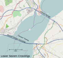
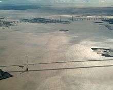
The Second Severn Crossing (Welsh: Ail Groesfan Hafren) is the M4 motorway bridge over the River Severn between England and Wales, inaugurated on 5 June 1996 by HRH The Prince of Wales to supplement the traffic capacity of the original Severn Bridge built in 1966. The bridge marks the lower limit of the River Severn and the start of the Severn Estuary.
It is further south than the old bridge; as it is closer in line with the landward sides of the M4, it gives a shorter journey when travelling between England and South Wales. The junctions at each end are designed for most traffic to use this crossing, and in order to use the old Severn Bridge crossing, one has to leave the M4 and join the M48 either at Aust or near Magor. The new crossing carries more traffic than the Severn Bridge, which is still in use. It is much wider than the Severn Bridge, having three lanes and a narrow hard shoulder each way, compared to the two lanes, cycle path and narrow footpath of the original crossing. The path taken by the bridge is close to that of the Severn Tunnel, which has carried the railway line beneath the river bed since 1886.
Much of the estuary is mudflats at low tide, but at high tide these can be covered by as much as 14 metres (46 ft) of water. This presented the engineers with a constraint: packets of work were scheduled at low tide, and needed to be completed within the short windows allowed by the tides.
The concession given to the consortium which financed, built and operate the bridge required them to take over the outstanding debt on the original Severn Bridge and to operate the two bridges as a single entity. Tolls are set annually by the government based on the previous year's change in the Retail Price Index. On the expiry of the concession the consortium is required to hand the bridge over to public ownership. It was reported in 2012 that the repayments were likely to continue until the early 2020s due to the introduction of a revised settlement to the operator in return for accepting payment by debit and credit cards. The announcement said that even after repayment was complete the toll charges would likely remain at the same levels.[1]
Background
The Severn Estuary presented a barrier between the Bristol area and South Wales. The estuary has a maximum tidal range of 14.5 metres, the second highest in the world, and during a rising or falling tide there are strong currents of up to 8 knots (4 m/s). Much of the estuary is mud flats that are exposed at low tide; these have been designated a Special Protection Area. The central part of the estuary is a navigable channel which, at the site of the bridge, is known as "The Shoots". The bridge is upstream from Avonmouth and the Port of Bristol, but downstream from the Port of Sharpness. The Gloucester Harbour Trustees have responsibility for controlling navigation in the estuary's tidal waters upstream from the bridge.[2]
Until 1966, road travellers could either use the Aust Ferry, which had operated since medieval times (and as a car ferry since 1926) or make a 57 miles (92 km) detour via Gloucester.[3] In 1966 the first Severn road bridge, a four-lane suspension bridge, was opened, carrying the M4 motorway between England and South Wales. By 1984 traffic across the first Severn Bridge had tripled and it was projected that by the mid-1990s the old bridge would be running at capacity. A study was commissioned into the building of a second crossing – either a tunnel or a bridge. The consultants reported back in 1986 recommending that a new bridge be built downstream from the existing bridge.[4][5]
In 1988 it was announced that tenders would be invited from private consortia to fund, build and operate the bridge for a specified period. The consortium would also take over the management of the old bridge and the associated £100 million debt.[6] Tenders were invited in 1989; and in 1990 the concession to build the bridge was awarded to Severn River Crossing plc.[7] Construction work started on 26 April 1992 and the bridge was opened by the Prince of Wales on 5 June 1996.[4]
Design

The architect and aesthetic consultant for the bridge was Ronald Weeks of Percy Thomas Partnership.[8] The bridge has portals close to Sudbrook, Monmouthshire on the Welsh side and Severn Beach in South Gloucestershire on the English side. It has three principal sections – a 25 span viaduct on the English side of length 2,103 m (6,900 ft; 1.307 mi), a 24 span viaduct of length 2,077 m (6,814 ft; 1.291 mi) on the Welsh side and the bridge itself, a 948 m (3,110 ft; 0.589 mi) structure with a 37 m (121 ft) navigational clearance, giving a total length of 5,128 m (16,824 ft; 3.186 mi).[9][10] The central section, called the Shoots Bridge, is of cable-stayed design and the central span (between the bridge pylons) is 456 metres (1,496 ft) in length. The approach viaducts are of a segmental bridge design. The crossing forms a very slight "S" curve – the roadway has an approximate east-west alignment at each of the portals, while the central bridge follows an alignment approximately WNW to ESE.
The Severn Railway Tunnel passes under the estuary bed on a line which is generally about 500 m upstream of the bridge, but which passes under the line of the bridge close to the English shore.[11][12]
The deck, which carries three lanes of traffic in each direction, is 34.6 metres (114 ft) wide. The sides of the bridge are fitted with 3 metres (9.8 ft) baffle plates to reduce lateral wind loads coming from the Severn Estuary onto the traffic; this has reduced the number of times that speed restrictions have been needed. The overall design of the new crossing makes it more resistant to high winds than the old Severn Bridge.[9]
Construction

The crossing was built by a business consortium under a public-private partnership. A company called Severn River Crossing plc, led by John Laing plc and GTM-Entrepose, was formed to build the new crossing.[13] This company also took over the responsibility of managing and maintaining the old Severn Bridge crossing, as well as managing and maintaining the new crossing. The cost of constructing the new crossing was expected to be paid for by tolls collected from motorists using the two crossings. Work on the new crossing began in 1992. Completion was in 1996.
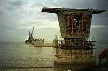
Sub-assemblies for the bridge were constructed onshore and then shifted by a large tracked vehicle (similar to that used to move the Apollo and Space Shuttle at Cape Kennedy) onto a barge (the SAR3), prior to being floated out on the high tide to the site. The 37 bridge pier foundations on the approach viaducts are 98.11 metres (321.9 ft) apart, and consist of open concrete caissons weighing up to 2,000 tonnes, which were founded on the rock of the estuary bed. The decking consists of 3.6 metres (11.8 ft) post-stressed match cast sections, weighing 200 tonnes each.[9]
The cable-stayed section of the crossing is over 1,044.7 metres (3,427.5 ft) long, consisting of a 34.6 metres (113.5 ft) wide deck made from steel plate girders with a composite reinforced concrete slab. These were prefabricated on shore and put in place using balanced cantilever methods. There are two high twin-leg, reinforced and pre-stressed concrete pylons carrying 240 cables which support the bridge deck, rising to a height of 149 metres (489 ft) above the river bed or 101 metres (331 ft) above the bridge deck. Cable vibrations were experienced during construction and secondary cables were added to eliminate this. To avoid detracting from the aesthetics of the primary cables, the secondary cables are very slender and are not very noticeable.[9]
During the summer of 1994 the bridge deck launching gantry fell onto the Gwent viaduct, causing the 200 tonne bridge deck unit to fall onto the deck below. Although this delayed the project by ten weeks, the builders still completed the bridge on schedule two years later.[14]
Environmental impact
Prior to the bridge's construction, environmentalists raised numerous concerns and criticisms, chiefly about the immediate damage from construction work and the effects of long-term pollution from a projected increase in car traffic.
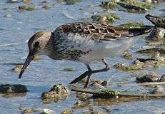
The crossing passes over mudflats in the Severn Estuary with part of the eastern approach viaduct sited on the English Stones, a rocky outcrop uncovered at low tide. The estuary wetlands are home to migrating birds such as the ringed plover, redshank and whimbrel, while the Eurasian curlew, dunlin and grey plover winter in the area. The birds feed on ragworm, lugworm and other invertebrates. Saltmarsh is found along the fringes of the coast. Beds of eelgrass occur on the more sheltered mud- and sandbanks.[15] In 1976, in recognition of the importance of the estuary as a wetland used by migrating birds, an area of 247 km2 (95 sq miles) was designated a Ramsar site.[16] In 1988 the Severn Estuary was designated a Special Protection Area. The same year an area of 99 km2 (38 sq miles) was notified as a SSSI and designated as such the following year;[15] in 1995, this was extended to cover the whole of the Ramsar site.[17]
The construction process resulted in a temporary increase in turbidity of the Severn's waters. Although eelgrass is reasonably tolerant to short-term high turbidity and consequent loss of light, the bed of eelgrass in the Severn was observed to decline considerably during the period of construction.[18] The construction of the approach roads and toll plaza resulted in the permanent loss of some wet pastureland.[19]
Field surveys carried out in 2003 and 2004 reported that the bridge had little effect on the flight paths of the various birds – it was noted that when curlews, dunlins and lapwings approached the bridge, they would change course to gain height and fly over the bridge, but that oystercatchers and turnstones would fly under the bridge. The surveys also showed that the bridge had minimal impact on the roosting habits of most birds, though a flock of mallards were seen to be roosting directly under the bridge, with many positioning themselves on the dry concrete base on one of the pillars. Likewise, it was noted that the bridge had little impact on the birds' feeding habits – turnstones and lapwings were recorded as feeding on mudflats directly under the bridge while the absence of other waders was attributed to the rocky nature of the foreshore.[15]
Finances
The consortium consisting of two civil engineering firms and two banks that funded and built the bridge has a 30-year concession to redeem its outlay from tolls collected from users of the bridge. At the end of the concession period, the bridge will pass into public ownership.[14]
Tolls

Tolls are collected from westbound traffic only, near Rogiet, some 2.1 miles (3.4 km) from the Welsh portal of the bridge.[7] Tolls can be paid by cash, major credit or debit cards, or by use of the Severn TAG system, which is a wireless electronic toll collection system that does not require vehicles to stop.[20] Cash, credit, or debit cards can be used at the manned booths; only credit and debit cards can be used at the automated coin gates.
Tolls charges are based on a three-tier pricing system:[21]
| Toll category | Description | 2016 charge |
|---|---|---|
| Cars and minibuses with up to 9 seats | ||
| Small buses with up to 17 seats Vans up to 3.5 tonnes |
||
| Buses with more than 17 seats Goods vehicles weighing 3.5 tonnes or more |
Motorcycles and UK disabled badge holders travelling in a vehicle are exempted from paying a toll, although these vehicles must stop at the toll booth to confirm their eligibility.
The toll prices are updated every year on 1 January in accordance with the Severn Bridges Act 1992.[22][23][24] In late 2008, UK VAT was reduced from 17.5% to 15%, but the bridge toll remained unchanged. For convenience the tolls are kept at round multiples of 10p (the bridge toll is largely paid in cash as card payments were not accepted until mid-2012), but the 13p VAT reduction was not passed on immediately. In 2009, the planned toll for cars would have been £5.50, as the announcements listed,[22][24] but the actual toll charged was £5.40. George Osborne, the then Chancellor of the Exchequer, announced in March 2015 that the tolls would be reduced to £5.40 in 2018, due to VAT being removed when the bridge comes into public ownership.[25][26]
In the 2016 United Kingdom budget, Osborne announced that toll charges on the Severn crossings would be halved in 2018.[25]
Historical toll charges
The toll levied on the Second Severn Crossing has always been identical to that on the Severn Bridge.
| Date | Category 1 | Category 2 | Category 3 |
|---|---|---|---|
| 5 June 1996 | £3.80 | £7.70 | £11.50 |
| 1 January 1997 | £3.90 | £7.80 | £11.70 |
| 1 January 1998 | £4.00 | £8.10 | £12.10 |
| 1 January 1999 | £4.20 | £8.40 | £12.50 |
| 1 January 2000 | £4.20 | £8.50 | £12.70 |
| 1 January 2001 | £4.40 | £8.70 | £13.10 |
| 1 January 2002 | £4.40 | £8.90 | £13.30 |
| 1 January 2003 | £4.50 | £9.00 | £13.50 |
| 1 January 2004 | £4.60 | £9.30 | £13.90 |
| 1 January 2005 | £4.80 | £9.60 | £14.30 |
| 1 January 2006 | £4.90 | £9.80 | £14.70 |
| 1 January 2007 | £5.10 | £10.20 | £15.30 |
| 1 January 2008 | £5.30 | £10.60 | £15.90 |
| 1 January 2009 | £5.40 | £10.90 | £16.30 |
| 1 January 2010[22] | £5.50 | £10.90 | £16.40 |
| 1 January 2011[27] | £5.70 | £11.50 | £17.20 |
| 1 January 2012[21] | £6.00 | £12.10 | £18.10 |
| 1 January 2013[28] | £6.20 | £12.40 | £18.60 |
| 1 January 2014[29] | £6.40 | £12.80 | £19.20 |
| 1 January 2015[30] | £6.50 | £13.10 | £19.60 |
| 1 January 2016[31] | £6.60 | £13.20 | £19.80 |
Funding and ownership
The bridge was built at a cost of £380 million and is owned by the company Severn River Crossing Plc. As of November 2010, Severn River Crossing Plc was owned
- 35% John Laing, British developer infrastructure operator
- 35% Vinci, French concessions and construction company
- 15% Bank of America, American multinational banking and financial services corporation
- 15% Barclays Capital, British multinational investment bank[32]
The company's 2011 annual report showed the same companies still owned, through subsidiary companies, all the issued ordinary share capital of the Plc.[33]
Ownership of the crossing and the original Severn Bridge will return to the UK government when the project's required revenue, as defined in the Concession Agreement with the Secretary of State for Transport, has been collected.[33] In 2010, the concession was expected to end in 2017.[34] In 2012, changes were made to the agreement to reflect the effect of changes in VAT and Corporation Tax and the costs of installing credit card handling systems. The net effect was to increase the required revenue from £995.83 million to £1,028.91 million in 1989 prices[32][35] and extending the contract to 2018. It was later announced that these changes and future unspecified repairs were likely to mean that repayment would continue until the early 2020s and that its users should not expect tolls to reduce even after repayment has been completed.[1]
Closures
On 6 February 2009, the bridge was closed by weather for the first time since its opening, after three vehicles were struck by falling ice, damaging windscreens.[36] Bad weather, and again falling ice, repeated this in December 2009.[37] Temporary speed limits are put in place due in high winds or thick fog, with drivers informed by the electronic signs. Because of the more advanced aerodynamic design of the later bridge, the Second Crossing is far less prone to such restrictions caused by crosswinds than the first Severn Bridge.

See also
References
- 1 2 http://www.bbc.co.uk/news/uk-wales-19967175
- ↑ "Gloucester Harbour Trustees: About the trustees". 2013. Retrieved 22 March 2013.
- ↑ Journeys between Newport and Bath are reduced from 161 km to 69 km -ViaMichelin.
- 1 2 "Second Severn Crossing". Engineering Timelines. Retrieved 17 March 2013.
- ↑ http://hansard.millbanksystems.com/lords/1986/jul/24/second-severn-crossing
|chapter-url=missing title (help). Parliamentary Debates (Hansard). United Kingdom: House of Lords. 24 July 1986. col. 382–383. Retrieved 17 March 2013. - ↑ http://hansard.millbanksystems.com/commons/1988/jul/28/second-severn-crossing
|chapter-url=missing title (help). Parliamentary Debates (Hansard). United Kingdom: House of Commons. 28 July 1988. col. 556–564. Retrieved 17 March 2013. - 1 2 "The Severn Crossing – Facts and Figures". Highways Agency. Retrieved 17 March 2013.
- ↑ Sophie Weeks
- 1 2 3 4 "History and Statistics of The Second Severn Crossing – Building The Second Severn Crossing". Severn River Crossing plc. 2011. Retrieved 16 March 2013.
"Second Severn Crossing, England". Department of Civil Engineering, University of Bristol. 2013. Retrieved 16 March 2013. - ↑ "Second Severn Crossing, England and Wales – Halcrow Group". Halcrow.com. 2009-10-29. Retrieved 2012-11-26.
- ↑ "Classic Projects: Second Severn Crossing". The Institution of Engineering and Technology. Retrieved 20 March 2013.
- ↑ (Google Maps: 51.587416N 2.701263W) (Map). Retrieved 20 March 2013.
- ↑ "Bridge legislation". Severn River Crossing Plc. Retrieved 2007-12-26.
- 1 2 McCormack, Steve (9 May 1996). "Severn up and ready". Construction News. Retrieved 17 March 2013.
- 1 2 3 "The Mersey Gateway Project – Chapter 10 Terrestrial and Avian ecology" (PDF). March 2008. Appendix 10.22 – The Impact on Wading Birds of the M4 Severn Road Bridge: Literature Review and Field Surveys (January 2006).
- ↑ "The Ramsar Convention on Wetlands". Ramsar. Retrieved 18 March 2013.
- ↑ "Information Sheet on Ramsar Wetlands (RIS)" (PDF). Peterborough: Joint Nature Conservation Committee. 13 July 1995. Retrieved 19 March 2013.
- ↑ "Dredging and disposal: Suspended sediments and turbidity". UK Marine SACs Project. 2001. Retrieved 19 March 2013.
- ↑ Davidson, N.C. (1996). Barne, J.H.; Robson, C.F.; Kaznowska, S.S.; N.C. Davidson, J.P. Doody; Buck, A.L., eds. "Coasts and seas of the United Kingdom. Region 11 The Western Approaches: Falmouth Bay to Kenfig," (PDF). Coastal Directories Series. Peterborough: Joint Nature Conservation Committee: 56. ISBN 1 873701 85 3.
|chapter=ignored (help) - ↑ "Current Toll Prices – Severn Bridge". Severn River Crossing plc. 2013. Retrieved 2013-06-18.
- 1 2 "Severn Bridge toll to increase to £6 in January 2012". BBC News. 25 November 2011. Retrieved 27 November 2011.
- 1 2 3 "Severn Bridge Tolls". Severn River Crossing Plc. Archived from the original (PDF) on 2010-09-28. Retrieved 2010-09-28.
- ↑ "Severn Bridge Act 1992". Office of Public Sector Information. Retrieved 2009-08-03.
- 1 2 "Severn Bridge tolls rise in 2009". BBC Online. 19 November 2008 (before VAT cut). Check date values in:
|date=(help) - 1 2 "Budget 2016: Severn bridge tolls to be halved". BBC. 2016-03-16. Retrieved 2016-03-17.
- ↑ "Budget 2015: Severn Bridge tolls to be cut, says Osborne". BBC News. BBC. 18 March 2015. Retrieved 21 March 2016.
- ↑ "Severn Bridge Tolls". Severn River Crossing Plc. Archived from the original (PDF) on 2011-01-09. Retrieved 2011-01-09.
- ↑ "Severn Bridge Crossing Toll increase 2013" (PDF). Retrieved 26 November 2012.
- ↑ "Severn bridges toll to increase to £6.40 in January 2014". BBC News. 18 November 2013. Retrieved 18 November 2013.
- ↑ "Severn Bridge tolls to be increased in January 2015". BBC News. 14 November 2014. Retrieved 14 November 2014.
- ↑ "Severn Bridge tolls to increase in 2016". ITV News. 16 November 2015. Retrieved 1 January 2016.
- 1 2 "The Severn Crossings Toll – Welsh Affairs Committee – Examination of Witnesses". Minutes of Evidence. House of Commons Welsh Affairs Committee. 2010. Retrieved 2013-01-12.
- 1 2 "Financial Statements for the Year Ended 31 December 2011". Severn River Crossing Plc. 2012-04-13. Retrieved 2013-01-12.
- ↑ "MPs learn Severn Crossing tolls should fall in 2017". BBC News Online. 2010-11-04. Retrieved 2013-01-12.
- ↑ "Notice of a meeting of the holders of the £127,500,000 6.125 per cent. index linked debenture stock". Severn River Crossing Plc. 2012-04-13. Retrieved 2013-01-12.
- ↑ "Second Severn crossing stays shut". BBC Online. 6 February 2009.
- ↑ "Falling ice closes the second Severn bridge". BBC News Online. 22 December 2009.
External links
| Wikimedia Commons has media related to Second Severn Crossing. |