Sebastopol, California
| City of Sebastopol | |
|---|---|
| City | |
|
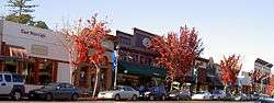
Main Street in Downtown Sebastopol | |
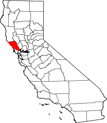
 Location in Sonoma County and the State of California | |
 City of Sebastopol Location in the United States | |
| Coordinates: 38°23′57″N 122°49′37″W / 38.39917°N 122.82694°WCoordinates: 38°23′57″N 122°49′37″W / 38.39917°N 122.82694°W | |
| Country |
|
| State |
|
| County | Sonoma |
| Incorporated | June 13, 1902[1] |
| Government | |
| • Type | Council-manager |
| • Mayor | Sarah Glade Gurney[2] |
| • State Senator | Mike McGuire (D)[3] |
| • Assemblymember | Marc Levine (D)[3] |
| • U. S. Rep. | Jared Huffman (D)[4] |
| Area[5] | |
| • Total | 1.853 sq mi (4.799 km2) |
| • Land | 1.853 sq mi (4.799 km2) |
| • Water | 0 sq mi (0 km2) 0% |
| Elevation[6] | 82 ft (25 m) |
| Population (2010) | |
| • Total | 7,379 |
| • Density | 4,000/sq mi (1,500/km2) |
| Time zone | PST (UTC-8) |
| • Summer (DST) | PDT (UTC-7) |
| ZIP codes | 95472-95473 |
| Area code | 707 |
| FIPS code | 06-70770 |
| GNIS feature IDs | 277599, 2411857 |
| Website |
www |
Sebastopol /səˈbæstəpoʊl/ or /səˈbæstəpuːl/ is a city in Sonoma County, California, United States, approximately 52 mi (80 km) north of San Francisco. The population was 7,379 at the 2010 census, but its businesses also serve surrounding rural portions of Sonoma County, a region known as West County, which has a population of up to 50,000 residents.[7][8]
It is about a 20-minute drive from the Pacific Ocean, between Santa Rosa and Bodega Bay, and is known for its liberal politics and small-town charm. It was once primarily a plum and apple growing region; wine grapes, however, are now predominant, and nearly all lands once used for orchards are now vineyards. World-famous horticulturist Luther Burbank had gardens in this fertile region. The city hosts an annual Apple Blossom Festival[9] and Gravenstein Apple Fair.[10]
History
The area's first known inhabitants were the native Coast Miwok and Pomo peoples. The town of Sebastopol formed in the 1850s with a U.S. Post Office and as a small trade center for the farmers of the surrounding agricultural region. As California's population swelled after the westward migration and the California Gold Rush of 1848-1855, more and more settlers drifted into the fertile California valleys north of San Francisco to try their hand at farming.
There is some debate about how the name "Sebastopol" came into use in Sonoma County. At one time, four other California towns were also named Sebastopol:
- one in Napa County, renamed Yountville
- one in Tulare County
- one in Sacramento County
- one in Nevada County
The town in Sonoma County originally had the name Pinegrove; the name change (according to rumor) had something to do with a bar fight in the late 1850s, which was linked to the long British siege of the seaport of Sevastopol (1854-1855) during the Crimean War of 1853-1856. The original name survives in the names of two of the longer-standing downtown businesses: Pinegrove consignment store, and the Pinecone restaurant.
It is sometimes thought (mistakenly) that the name of "Sebastopol" is the result of an error in the transliteration of Sevastopol ("Севастополь", Sevastopol in Russian, "Σεβαστούπολη", Sevastupoli in the original Greek). However, both the Greek letter "β" (v) and the Cyrillic "в" (v) have been historically Romanized as "b" (other examples include "Βυζάντιον", Vizantion → Byzantium; the Greek name "Βασίλειος", Vassilios and the Russian "Василий", Vassily → Basil, the Byzantine title "σεβαστοκράτωρ"/"севастократор" sevastokrator → sebastokrator, etc.). In fact, 19th-century English-language sources generally referred to the eponymous city on the Crimean peninsula as "Sebastopol". (The Ancient Greek letter beta ("β"), originally representing a plosive /b/, had generally became a fricative /v/ in spoken Greek by the Middle Ages - see Koine Greek phonology. The Russian-language pseudo-Greek invented name for Sevastopol in the Crimea dates only from the 18th century.)
Sebastopol became known as the "Gravenstein Apple Capital of the World". The apple industry brought a steady rural prosperity to the town. In 1890 the San Francisco and North Pacific Railroad connected Sebastopol to the national rail network.[11] The town was incorporated in 1902, with schools, churches, hotels, canneries, mills, wineries, and an opera house to its credit. The 1906 earthquake reduced most of these early buildings to rubble (Sebastopol is only seven miles from the city of Santa Rosa, the worst-hit town in the 1906 earthquake), but as elsewhere in the county, the town was rebuilt.
In the second half of the 20th century, the apple industry struggled to compete with other apple-producing regions and gradually declined in economic significance. With greater personal mobility and the rise of larger shopping centers in other Sonoma County communities, many residents now often commute to work and shop in the neighboring towns of Rohnert Park or Santa Rosa, while Sebastopol maintains its small-town charm.
It is often incorrectly claimed that Sebastopol was the last town in Northern California to have working railroad trains on Main Street. The tracks were removed in the late 1980s. Passenger service had ceased in the 1930s, and regular freight service ended in the late 1970s. This was documented by Analy High School students in a 1979 video Our Train Down Main: a History of the Petaluma and Santa Rosa Railroad. The canneries and apple-processing plant are gone from downtown, and vineyards and housing developments have replaced many apple orchards, reducing the demand for freight service.
It is often also incorrectly stated that the tracks were removed in the 1990s when the downtown area was redesigned with two one-way streets to enhance traffic along Gravenstein Highway (Route 116). Main Street and Petaluma Avenue were actually designated one-way streets in 1985 in a perhaps misguided attempt to deal with the town's perennial traffic problem. As of 2016 the old train station houses the Western County Museum.
Notable people
Some famous residents of Sebastopol include:
- Luther Burbank, horticulturist who established an 18-acre (73,000 m2) Gold Ridge Environmental Farm in the township in the late 19th century
- Les Claypool, bassist/vocalist of the band Primus
- Dave Schools, bassist of the band Widespread Panic
- Jerry Garcia and Mickey Hart of the Grateful Dead
- Schuyler Grant, actress of the 1985 adaptation of Anne of Green Gables
- Nick Gravenites, singer/songwriter
- J.Lately, rapper
- Kitaro, Japanese New Age recording artist
- Bill Knickerbocker, baseball player, died in Sebastopol
- Peter Krause, actor[12]
- Willard Libby, inventor of carbon dating, went to Analy High School
- Megan McDonald, an American children's literature author of more than 25 books including the Judy Moody & Stink Moody series
- Matt Nix, show runner for Burn Notice
- Johnny Otis, rhythm and blues pioneer
- Justin Raimondo, author[13][14]
- Francine Rivers, novelist
- Mario Savio, freedom activist
- Charles M. Schulz, cartoonist and creator of Peanuts
- Rider Strong, actor
- Smoov-E, rapper
- Karen Valentine, actress of the television show Room 222
- Obie Scott Wade, screenwriter and creator of SheZow, went to Analy High School
- Tom Waits, singer/songwriter/musician
- Kate Wolf, singer/songwriter
Geography

Sebastopol's elevation is 65 to 250 feet (20 to 75 meters) above sea level. Its downtown is at the intersection of State Route 12 and State Route 116 (aka Gravenstein Highway), approximately 9 mi (14 km) west of U.S. Route 101.
Sebastopol is situated on the edge of the Laguna de Santa Rosa, which is fed by Santa Rosa Creek and other tributaries, including three minor tributaries within the city limits – Zimpher Creek, Calder Creek and Witter Creek. The Laguna is a wetland area that is home to many species of wildlife and vegetation, and divides the town from the neighboring Santa Rosa. Nearly every winter the Laguna floods, cutting off State Route 12, and often flooding the low-lying businesses and homes on the eastern side of Sebastopol. The Pitkin Marsh lily and White sedge are two rare species of plants that are found in the vicinity of Sebastopol.
The town currently sits atop several sites of Pomo Indian villages, and arrowheads are found in gopher holes with some frequency in the less disturbed areas of town bordering the flood plain.
The city has a total area of 1.9 sq mi (4.9 km2), all land.[15]
Demographics
| Historical population | |||
|---|---|---|---|
| Census | Pop. | %± | |
| 1880 | 197 | — | |
| 1910 | 1,233 | — | |
| 1920 | 1,493 | 21.1% | |
| 1930 | 1,762 | 18.0% | |
| 1940 | 1,856 | 5.3% | |
| 1950 | 2,601 | 40.1% | |
| 1960 | 2,694 | 3.6% | |
| 1970 | 3,993 | 48.2% | |
| 1980 | 5,595 | 40.1% | |
| 1990 | 7,004 | 25.2% | |
| 2000 | 7,774 | 11.0% | |
| 2010 | 7,379 | −5.1% | |
| Est. 2015 | 7,678 | [16] | 4.1% |
2010
The 2010 United States Census[18] reported that Sebastopol had a population of 7,379. The population density was 3,982.4 people per square mile (1,537.6/km²). The racial makeup of Sebastopol was 6,509 (88.2%) White, 72 (1.0%) African American, 60 (0.8%) Native American, 120 (1.6%) Asian, 19 (0.3%) Pacific Islander, 298 (4.0%) from other races, and 301 (4.1%) from two or more races. Hispanic or Latino of any race were 885 persons (12.0%).
The Census reported that 98.3% of the population lived in households and 1.7% were institutionalized.
There were 3,276 households, out of which 902 (27.5%) had children under the age of 18 living in them, 1,220 (37.2%) were opposite-sex married couples living together, 478 (14.6%) had a female householder with no husband present, 156 (4.8%) had a male householder with no wife present. There were 206 (6.3%) unmarried opposite-sex partnerships, and 52 (1.6%) same-sex married couples or partnerships. 1,132 households (34.6%) were made up of individuals and 498 (15.2%) had someone living alone who was 65 years of age or older. The average household size was 2.21. There were 1,854 families (56.6% of all households); the average family size was 2.82.
The population was spread out with 1,515 people (20.5%) under the age of 18, 471 people (6.4%) aged 18 to 24, 1,587 people (21.5%) aged 25 to 44, 2,525 people (34.2%) aged 45 to 64, and 1,281 people (17.4%) who were 65 years of age or older. The median age was 46.1 years. For every 100 females there were 79.9 males. For every 100 females age 18 and over, there were 76.7 males.
There were 3,465 housing units at an average density of 1,870.0 per square mile (722.0/km²), of which 52.9% were owner-occupied and 47.1% were occupied by renters. The homeowner vacancy rate was 0.7%; the rental vacancy rate was 4.2%. 53.7% of the population lived in owner-occupied housing units and 44.5% lived in rental housing units.
The median income for a household in the city was $60,322 (+29.9% from 2000), and the median income for a family was $74,020 (+32.7% from 2000). The median per capita income for the city was $29,470 (+28.8% from 2000). For comparison, statewide California median per capita income in the 2010 Census was $27,885 (+22.8% from 2000).
2000
As of the census[15] of 2000, there were 7,774 people, 3,250 households, and 1,953 families residing in the city. The population density was 4,139/sq mi (1,597/km²). There were 3,321 housing units at an average density of 1,768/sq mi (682/km²). The racial makeup of the city was 89.85% White, 0.66% African American, 0.78% Native American, 1.52% Asian, 0.10% Pacific Islander, 3.86% from other races, and 3.23% from two or more races. Hispanic or Latino of any race were 9.26% of the population.
There were 3,250 households out of which 31.8% included children under the age of 18 in the house, 41.5% were married couples living together, 14.2% were led by a female householder with no husband present, and 39.9% were other living arrangements. 31.8% of all households were made up of a single individual and 14.3% had someone living alone who was 65 years of age or older. The average household size was 2.33 and the average family size was 2.95.
For the most part the population is spread out across the age groups, although the young adult population is drastically lower than the other groups, indicating that most young people leave, at least temporarily. The reasons for this are probably a combination of the high cost of living and the lack of other young adults. The percent distribution on the 2000 census by age was as follows: 23.6% under the age of 18, 7.4% from 18 to 24, 25.0% from 25 to 44, 27.6% from 45 to 64, and 16.5% who were 65 years of age or older. The median age was 42 years.
For every 100 females there were 81.1 males. For every 100 females age 18 and over, there were 75.3 males.
The median income for a household in the city was $46,436, and the median income for a family was $55,792. Males had a median income of $40,538 versus $32,399 for females. The per capita income for the city was $22,881. About 4.7% of families and 6.9% of the population were below the poverty line, including 6.7% of those under age 18 and 6.0% of those age 65 or over.
Government
Local
The city council consists of five members, each serving four year terms. The city's laws are enforced by the Sebastopol Police Department. City council races are not partisan, so each member does not officially represent any party, however since 2000 there has been a decent amount of attention given to the individual party membership of city council members in Sebastopol. This happened because in 2000, with the election of Craig Litwin and Sam Spooner to the city council, the town had a Green Party majority—or would have, if city council races were partisan. This was only the second time this had ever happened in California, the first being the town of Arcata, California in 1996.
As this indicates, Sebastopol tends to support environmental policies. In 1986, the citizens approved an initiative declaring Sebastopol a "Nuclear Free Zone", The town does not use pesticides in city landscaping, and several years back, when the police needed a new vehicle, the city council voted to purchase a hybrid instead of a standard police car.
Current issues facing the city include a high cost of living and ongoing difficulties with traffic (the town has two highways going through downtown).
The current city council members (as of March 2016) are:[19]
- Sarah Glade Gurney, Mayor
- Una Glass, Vice Mayor
- Patrick Slayter
- John Eder
- Robert Jacob
About Former Mayor, Robert Jacob: In December 2013, the city council selected Robert Jacob to the mayoral post. Jacob, the owner of two medical marijuana dispensaries in Sonoma County, is believed to be the first American mayor to be involved in the industry.[20]
State and federal
In the California State Legislature, Sebastopol is in the 10th Assembly District, represented by Democrat Marc Levine, and California's 2nd State Senate district.
Federally, Sebastopol is in California's 2nd congressional district, represented by Democrat Jared Huffman.[21]
Sister cities
Places of interest
Sebastopol, while small, has several points of interest.
- Sebastopol Center for the Arts (SCA)
- Luther Burbank Gold Ridge Experiment Farm[23]
- Guayaki Sustainable Rainforest Products, Inc world headquarters
- The historic Hogan Building, Petaluma Avenue. This was the Power House for the Petaluma and Santa Rosa Railroad, an electric railway. The first cars were run over the line in 1904, and the later named Hogan Building, built of stone from a local quarry, is one of the few in the area that made it through the 1906 earthquake.
- West County Museum operated by the Western Sonoma County Historical Society in the former Petaluma and Santa Rosa Railroad passenger depot on Main Street.
- George A. Strout House, located on Florence Ave.
- Ives Park, summer home of the Sonoma County Repertory Theater (aka The Rep)
- Ragle Ranch Regional Park
- Joe Rodota Trail
- West County Trail
- Laguna de Santa Rosa
- Florence Avenue is the home of Patrick Amiot's "junk art".
- Sebastopol Community Cultural Center offers a wide variety of events and activities for all interests.
- Sebastopol Arts Center offers events and activities in visual, performing, literary and film arts.
- Sebastopol is home to a one time, one starred, Michelin-starred restaurant: K&L Bistro on Main Street.
See also
 |
Occidental | Graton | Healdsburg Windsor |
|
| Freestone | |
Santa Rosa | ||
| ||||
| | ||||
| Valley Ford | Bloomfield | Rohnert Park Cotati |
References
- ↑ "California Cities by Incorporation Date" (Word). California Association of Local Agency Formation Commissions. Retrieved August 25, 2014.
- ↑ "Mayor Patrick Slayter". City of Sebastopol. Retrieved December 3, 2014.
- 1 2 "Statewide Database". UC Regents. Retrieved October 16, 2014.
- ↑ "California's 2nd Congressional District - Representatives & District Map". Civic Impulse, LLC.
- ↑ "2010 Census U.S. Gazetteer Files – Places – California". United States Census Bureau.
- ↑ "Sebastopol". Geographic Names Information System. United States Geological Survey.
- ↑ Norberg, Bob (October 24, 2012). "Sebastopol to weigh limit on number of alcohol-serving businesses". Press Democrat. Retrieved October 24, 2012.
- ↑ "City of Sebastopol, California". Retrieved March 22, 2016.
- ↑ "Apple Blossom Festival". Apple Blossom Festival. Retrieved August 25, 2015.
- ↑ "About the Gravenstein Apple Fair". Gravenstein Apple Fair. Retrieved August 25, 2015.
- ↑ Stindt, Fred A. (1978). The Northwestern Pacific Railroad Redwood Empire Route (3rd ed.). Fred A. Stindt.
- ↑ "Analy High School Centennial Celebration Historical Timeline". Analy High School. Retrieved January 11, 2009.
- ↑ "Justin Raimondo". Twitter. Retrieved March 22, 2016.
- ↑ "- ACLU of Northern California" (PDF). ACLU of Northern California. Retrieved March 22, 2016.
- 1 2 "American FactFinder". United States Census Bureau. Retrieved 2008-01-31.
- ↑ "Annual Estimates of the Resident Population for Incorporated Places: April 1, 2010 to July 1, 2015". Retrieved July 2, 2016.
- ↑ "Census of Population and Housing". Census.gov. Retrieved June 4, 2015.
- ↑ "2010 Census Interactive Population Search: CA - Sebastopol city". U.S. Census Bureau. Retrieved July 12, 2014.
- ↑ "Sebastopol City Council". City of Sebastopol, California. Retrieved March 20, 2016.
- ↑ "California Pot Clinic Owner Turns Mayor, 1st in Country". NBC Bay Area. Retrieved March 22, 2016.
- ↑ "California's 2nd Congressional District - Representatives & District Map". Civic Impulse, LLC. Retrieved March 1, 2013.
- ↑ "About Our Town". Retrieved August 13, 2010.
- ↑ National Register of Historic Places
- Our Train Down Main : a History of the Petaluma & Santa Rosa Railroad. Sebastopol, CA: Analy High School, 1979. Videocassette (ca. 22 min.)
External links
| Wikimedia Commons has media related to Sebastopol, California. |
| Wikivoyage has a travel guide for Sebastopol. |
- Official website
- West County Museum
- Sebastopol Community Cultural Center
- Sebastopol Arts Center
- Sebastopol Business Directory and Information
| Bodies of water |
|  |
|---|---|---|
| Counties | ||
| Major cities | ||
| Cities and towns 100k–250k | ||
| Cities and towns 50k–99k | ||
| Cities and towns 25k-50k | ||
| Cities and towns 10k–25k |
| |
| Sub-regions | ||