Seal Island (Nova Scotia)
Seal Island (also known as Great Seal Island) is an island on the outermost extreme of Southwestern Nova Scotia, Canada, in Municipalité Argyle Municipality in Yarmouth County.[1] It is approximately 2.7 miles long and 0.5 miles wide and is surrounded on its east, south and west sides by dangerous shoals.[2] It is the biggest of a group of five islands which extend north for 7.5 miles.[3] It is the second southernmost point of land of Nova Scotia. The southern tip of nearby Cape Sable is 250 m farther south than the southern tip of land on Seal Island.
History
During the American Revolution, Noah Stoddard's vessel the Scammell was commissioned in April 1782. Soon after, he rescued the 60 American prisoners on board H.M.S. Blonde, who were stranded on Seal Island after hitting Blonde Rock, Nova Scotia. Stoddard allowed the British crew to return to Halifax.[4]
The island was settled in 1823 by two families from the Barrington area, the Hitchens and the Crowells. They used the island as a fishing base and provided shelter to survivors of the many ships wrecked at the island and on nearby reefs. A campaign led by Mary Hitchens resulted in the construction of a lighthouse in 1831 which still stands, one of the oldest wooden lighthouses in Canada. Seal Island lightkeepers continued to rescue many shipwreck victims, most notably in 1843 when they saved all the crew and passengers of RMS Columbia, one of Samuel Cunard's first ocean liners.
The Seal Island settlement eventually contained two small villages, The East Side and The West Side. The East Side has historically been inhabited by descendants of the original settling families who owned the island, and the West Side by local fishermen. They shared a post office, church and a lobster cannery. Year round habitation ceased in 1990 but both villages host summer residents, most of whom have families who once lived on the island. An old cookhouse, referred to as North Home, standing in the woods near the West Side, was purchased by birdwatchers in the 50's and is now owned and maintained by their descendants. The East Side has lost its wharf, but retains the Seal Island Church of All Faiths and the East Side village. [5]
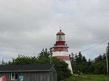
Seal Island Lighthouse
The Seal Island Lighthouse is the oldest wooden lighthouse in Nova Scotia and one of the oldest in Canada. The lighthouse was de-staffed in 1990. Lack of maintenance and poor ventilation of the lighthouse by the Canadian Coast Guard have raised fears about the condition of the historic structure.[6]
A replica of the Seal Island Lighthouse can be seen in Barrington, Nova Scotia.
References
- ↑ "Seal Island". Place Names. Natural Resources Canada. Retrieved 2 October 2015.
- ↑ Mc.Dougall, G.F. (1867). Sailing directions for the south-east coast of Nova Scotia and bay of Fundy. Hydrographic Office, Admiralty. p. 148. Retrieved 2 October 2015.
- ↑ Seal Island, Nova Scotia http://www.twrsoft.com/seal/sailing1.htm
- ↑ Sacking of Lunenburg. Saga of the Seas, Archibald MacMechan, 1923
- ↑ Seal Island Village http://www.nslps.com/lights/lighthouse_page_01.asp?ID=362&SP=5&M=The%20Light%20Today
- ↑ "Doomsday List" Nova Scotia Lighthouse Preservation Society
External links
- Nova Scotia Lighthouse Preservation Society: Seal Island Lighthouse
- Seal Island Lighthouse Museum, Cape Sable Historical Society
Coordinates: 43°24′56.1″N 66°0′37.4″W / 43.415583°N 66.010389°W