Seal Chart

Coordinates: 51°17′04″N 0°15′23″E / 51.284510°N 0.256260°E
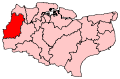
Seal Chart is a village 2 miles (3 km) east of Sevenoaks in Kent, England. It is within the Sevenoaks local government district. At the 2011 Census the population was included in the civil parish of Seal
External links
![]() Media related to Seal Chart at Wikimedia Commons
Media related to Seal Chart at Wikimedia Commons
This article is issued from Wikipedia - version of the 9/19/2016. The text is available under the Creative Commons Attribution/Share Alike but additional terms may apply for the media files.