Scola Tower
| Scola Tower | |
|---|---|
 | |
| Basic information | |
| Location |
|
| Geographic coordinates | 44°03′06.3″N 9°51′29.8″E / 44.051750°N 9.858278°ECoordinates: 44°03′06.3″N 9°51′29.8″E / 44.051750°N 9.858278°E |
| Affiliation | Roman Catholic |
| District | Liguria |
| Province | La Spezia |
| Ecclesiastical or organizational status | Military Tower |
| Architectural description | |
| Groundbreaking | 17th century |
| Completed | 17th century |
| Construction cost | 56.000 genoese liras |
| Specifications | |
| Height (max) | 4 metres (13 ft) |
| Materials | marble,stone |
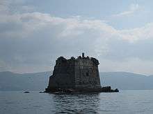
The Scola Tower - or tower of St. John the Baptist - is a former military building located just beyond the northeastern tip (called tip Scola) of Palmaria (island) in Portovenere, in the Gulf of Poets in the province of La Spezia, Italy. It is part of, along with the Fort Cavour and Umberto I and the Batteria Semaforo, the defensive positions of Palmaria.[1]
History and Description
As other coastal towers and lookout of the Ligurian coast, even the Scola Tower is part of that defensive system desired by the Senate of the Republic of Genoa in the 16th and 17th century to protect the coast and, consequently, the towns and villages. According to some studies, the tower, which cost an estimated 56,000 Genoese liras, may have been built in the early 17th century in response to the new demands that military ballistic and forced the Senate of Genoa to a rapid conversion of architectural sites defensive existing or create new ones anyway.
The tower is pentagonal in shape with an average thickness of the walls about 4 feet, which accommodates up to eight people, (eight soldiers, a captain and a master "bombardero") and ten cannons, and can cover "on fire" the stretch of sea between the Bay of Palmaria, Olive bay to Porto Venere and Lerici breast.
With the Napoleonic domination, it was at the center of the naval engagements of January 23, 1800, between the British and French fleets, to remove the latter from the Gulf of La Spezia, so that for the damages suffered by gunfire (demolition of the curtains of a side of the tower) was decided on total neglect in the first half of the 19th century.
Staved off the complete demolition in 1915, provided by the Navy, and deleted after the interest of an inspector that Ubaldo Mazzini monuments made a special report to the Ministry of Education, it was decided to convert the tower to a lighthouse tower. Between 1976 and 1980, the structure has undergone major restoration and consolidation of the perimeter wall.[2]
Lighthouse
 Scoglio Torre della Scuola Lighthouse | |
 Liguria | |
| Location |
Isola della Palmaria Portovenere Liguria Italy |
|---|---|
| Coordinates | 44°03′06.3″N 9°51′29.8″E / 44.051750°N 9.858278°E |
| Year first constructed | 1920s or 1930s |
| Construction | metal mast |
| Tower shape | cylindrical mast |
| Markings / pattern | white mast with light |
| Height | 2 metres (6.6 ft) |
| Focal height | 16 metres (52 ft) |
| Current lens | type TD |
| Light source | solar power |
| Intensity | 100 w |
| Range | 10 nautical miles (19 km; 12 mi) |
| Characteristic | Fl (2) W 6s. |
| Admiralty number | E1263 |
| NGA number | 7708 |
| Italy number | 1716 E.F. |
| Managing agent |
Marina Militare[3] [4] |
Scoglio Torre della Scuola Lighthouse (Italian: Torre della Scuola) is an active light placed on a metal mast 2 metres (6.6 ft) high atop the Tower and a focal height of 16 metres (52 ft). It is fully automated and operated by the Lighthouses Service of the Marina Militare identified by the code number 1716 E.F. The lighthouse has a solar power unit and emits two white flashes in a six seconds period visible up to 10 nautical miles (19 km; 12 mi).[4]
See also
References
- ↑ Palmaria (ed.). "Scola Tower".
- ↑ Isola Palmaria e Comune di Porto Venere Informazione Sostenibile. Retrieved 7 August 2016
- ↑ Torre della Scuola The Lighthouse Directory. University of North Carolina at Chapel Hill. Retrieved 7 August 2016
- 1 2 Scoglio Torre della Scuola Marina Militare. Retrieved 7 August 2016
External links
| Wikimedia Commons has media related to Scola Tower. |