Schiehallion
| Schiehallion | |
|---|---|
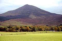
 The north-west ridge of Schiehallion in April | |
| Highest point | |
| Elevation | 1,083 m (3,553 ft) [1] |
| Prominence | c. 718 m |
| Parent peak | Ben Lawers |
| Listing | Munro, Marilyn |
| Coordinates | 56°40′4″N 4°5′52″W / 56.66778°N 4.09778°WCoordinates: 56°40′4″N 4°5′52″W / 56.66778°N 4.09778°W |
| Naming | |
| Translation | Fairy Hill of the Caledonians (Gaelic) |
| Pronunciation | Scottish Gaelic: [ʃiˈxaʎən̪ˠ] |
| Geography | |
 Schiehallion | |
| OS grid | NN714548 |
| Topo map | OS Landranger 51 |
Schiehallion (Scottish Gaelic: Sìdh Chailleann, Scottish Gaelic pronunciation: [ʃi'xaʎən̪ˠ]) is a prominent mountain in Perth and Kinross, Scotland. Schiehallion has a rich botanical life, interesting archaeology, and a unique place in scientific history for an 18th-century experiment in "weighing the world". The mountain's popularity amongst walkers led to erosion on its footpath and extensive repairs were undertaken in 2001.
Etymology
The name Schiehallion is an anglicised form of the Gaelic name Sìdh Chailleann, which translates as "Fairy Hill of the Caledonians". It is also known to some as "The Maiden's Pap", or "Constant Storm".[2] It is pronounced ''she-hally-on'' [3]
Location
Schiehallion lies between Loch Tay, Loch Rannoch and Loch Tummel, about 10 miles (16 kilometres) to the west-north-west of Aberfeldy in Perthshire.[4] The mountain, with an elevation of 3,553 feet (1,083 metres), is isolated from other peaks and has an almost perfectly conical shape from the west. The view of the broad eastern flank attracts many visitors to the shores of Loch Tummel.
Schiehallion is sometimes described as the centre of Scotland. The justification is that the line of latitude midway between the most northerly and southerly points on the Scottish mainland, and the line of longitude midway between the most easterly and westerly points, intersect very near the summit of Schiehallion.
Botany
The slopes of Schiehallion are rich in botanical life, with heathers, mosses and blaeberry. Blanket bog and heather moorland change colour with the seasons. The limestone pavement provides nutrients, supporting plants including dog's mercury, lily of the valley and wood anemone.[4]
History
The slopes of Schiehallion have been inhabited and cultivated since the first millennium BC until approximately two hundred years ago.[5] Schiehallion has been used for grazing sheep and stalking red deer.
Since 1999 the eastern side of the mountain has been owned by the John Muir Trust.[6]
The Schiehallion experiment
Schiehallion's isolated position and regular shape led it to be selected by Charles Mason for a ground-breaking experiment to estimate the mass of the Earth in 1774.[7] The deflection of a pendulum by the mass of the mountain provided an estimate of the mean density of the Earth, from which its mass and a value for Newton's Gravitational constant G could be deduced. Mason turned down a commission to carry out the work and it was instead coordinated by Astronomer Royal, Nevil Maskelyne. He was assisted in the task by mathematician Charles Hutton, who devised a graphical system to represent large volumes of surveyed heights, later known as contour lines.[8]
Footpath
A Munro, Schiehallion is popular with walkers due to its accessibility, ease of ascent and spectacular views. An estimated 17,500 to 20,000 walkers made the ascent in 2000.[6] Most walkers start from the Forestry Commission car park at Brae of Foss, which lies just outside the boundary of the John Muir Trust estate. The route, which initially heads southwest before turning west to follow the main ridgeline of the hill, is about 4.5 km in length.
Ben Nevis, the highest mountain in the British Isles, can be seen to the north from the summit of Schiehallion.
By 1999, when the John Muir Trust bought the estate, the main path had become exceedingly eroded by the passage of many thousands of walkers. The scar was visible from quite a distance. The organisation therefore decided to construct a new path, following a different line, better able to handle the pressure of visitors.
In culture
The Schiehallion oilfield is named after the mountain.[9] One of the major oilfields on Great Britain's continental shelf, it is operated by BP and situated in the North Atlantic approximately 180 mi (290 km) west of Shetland.
Schiehallion was the setting for the final showdown in Grant Morrison's comic series Zenith. The Harviestoun Brewery produce a cask-conditioned lager called Schiehallion. A Scottish Country Dance ("Schiehallion") and figure, the Schiehallion Reel are both named after the mountain. Song "Schiehallion" featured on the 1994 album Time For A New Day by the independent band King Rizla.
Pipe Major Donald Shaw Ramsay composed a 3/4 march entitled "Schiehallion".
The England-based band "Schiehallion Pipes and Drums" (named for the Munro) led by Drum Major Jim (Jaimie) Gibb, has adopted the march as their signature tune, and is indeed the lead-in tune on their album Hail! Schiehallion.
Gallery
Jun1998.jpg) View from the summit of Schiehallion looking over Loch Rannoch into the setting sun
View from the summit of Schiehallion looking over Loch Rannoch into the setting sun View from summit of Schiehallion towards Loch Tummel
See also
Footnotes
- ↑ "Walkhighlands Schiehallion". walkhighlands.co.uk. walkhighlands.co.uk. 2013. Retrieved 13 October 2013.
- ↑ "Maskelyne on Schiehallion". RMS Archives. Retrieved 11 April 2009.
- ↑ "Schiehallion". Walk Highlands. Retrieved 2015-06-16.
- 1 2 "Schiehallion". VisitScotland Perthshire. Retrieved 11 April 2009.
- ↑ Clare Thomas. "The Story of Schiehallion". archive-articles.co.uk. Retrieved 11 April 2009.
- 1 2 "East Schiehallion Estate". John Muir Trust. Retrieved 30 January 2008.
- ↑ Danson, Edwin (2006). Weighing the World. Oxford University Press. p. 116. ISBN 978-0-19-518169-2.
- ↑ Danson, Edwin (2006). Weighing the World. Oxford University Press. p. 153. ISBN 978-0-19-518169-2.
- ↑ Rob Edwards (30 April 2000). "Conservation trust attacked for accepting oil giant's cash". Sunday Herald. Retrieved 11 April 2009.
- Computer generated summit panoramas North

| Northern Highlands |   | |
|---|---|---|
| Western Highlands | ||
| Central and Eastern Highlands | ||
| Southern Highlands | ||
| Islands | ||
| Scottish Lowlands, England and Wales | ||