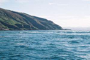
Scarba
Scarba (Scottish Gaelic: Sgarba) is a small island, in Argyll and Bute, Scotland, just north of the much larger island of Jura. The island was owned by Richard Hill, 7th Baron Sandys and has not been permanently inhabited since the 1960s.[3] It is now covered in heather and used for grazing animals. Kilmory Lodge is used seasonally as a shooting lodge, the island having a flourishing herd of red deer.
The island's name is from the Norse and may mean "sharp, stony, hilly terrain"[3] or "cormorant island".[5]
Description
Scarba is not served by any public ferries, but access from Craobh Haven or Crinan Harbour is possible by arrangement with local boatmen. The rough summit ridge can be accessed from the harbour at the north end, from where a vehicle track leads up past Kilmory Lodge to a height of about 200 metres. After that, there are no paths or well defined routes, and the terrain becomes rough and boggy. The island rises steeply to a peak (Cruach Scarba) of 449 metres (1,473 ft). Although there are no technical difficulties, the summits are often shrouded in mist, through which navigation skill may be required. A cylindrical triangulation point marks the highest of several summits, which are surrounded by several small lochs.
Corryvreckan
Between Scarba and Jura lies the Gulf of Corryvreckan, known for its whirlpool. Writing in 1549, Dean Monro wrote of "Skarbay" that between it and "Duray":
Ther runnes ane streame, above the power of all sailing and rowing, with infinite dangers, callit Corybrekan. This stream is aught myle lang, quhilk may not be hantit bot be certain tyds. This Skarbay is four myles lange from the west to the eist, and an myle breadth, ane high rough yle, inhabit and manurit, with some woods in it.[6]
Scarba and a few nearby islets (Lunga and the Garvellachs) are collectively the Scarba, Lunga and the Garvellachs National Scenic Area.
Gallery
References
External links
 Media related to Scarba at Wikimedia Commons
|
|---|
|
| |
|
|
|
|
|
|
|
|
|
| Culture |
|---|
| | Shetland | |
|---|
| | Orkney | |
|---|
| | Outer Hebrides | |
|---|
| | Inner Hebrides | |
|---|
|
|
|
| Politics |
|---|
| | Local authorities | |
|---|
| | Serving MSPs | |
|---|
| | Serving MPs | |
|---|
| | Other | |
|---|
|
|
|
| Wildlife |
|---|
| | Fauna | |
|---|
| | Flora | |
|---|
| | Domesticated animals | |
|---|
|
|
|
|
Coordinates: 56°10′34″N 5°43′24″W / 56.17607°N 5.72324°W / 56.17607; -5.72324

 The Corryvreckan whirlpool
 The view from Luing looking towards Scarba
 Na h-Urrachann, Isle of Scarba, looking north towards the Slate Islands
 A view northwards along the summit ridge from a short distance north of the highest point.