Sayler's Creek Battlefield
|
Sayler's Creek Battlefield | |
|
View from Ewell's right across Sayler's Creek (Hillsman House in background), 1936 NPS photo | |
  | |
| Location | Amelia / Prince Edward counties, Virginia, USA |
|---|---|
| Nearest city | Farmville, Virginia |
| Coordinates | 37°19′04″N 78°14′02″W / 37.31778°N 78.23389°WCoordinates: 37°19′04″N 78°14′02″W / 37.31778°N 78.23389°W |
| Area | 1,022 acres (4.14 km2)[1] |
| Architect | Unknown |
| Architectural style | Colonial |
| NRHP Reference # | 85002436 |
| VLR # | 004-0019 |
| Significant dates | |
| Added to NRHP | February 4, 1985[2] |
| Designated NHL | February 4, 1985[3] |
| Designated VLR | October 16, 1984[4] |

Sayler's Creek Battlefield near Farmville, Virginia was the site of the Battle of Sayler's Creek of the American Civil War. Robert E. Lee's army was retreating from the Richmond to Petersburg line. Here, on April 6, 1865, Union General Philip Sheridan cut off and beat back about a quarter of Lee's army. Eight Confederate generals surrendered, and 7,700 men were lost. Confederate Major General George Washington Custis Lee, eldest son of Robert E. Lee, was forcibly captured on the battlefield by Private David Dunnels White of the 37th Massachusetts Regiment. This was the last major engagement of the war in Virginia; Lee's surrender at Appomattox occurred three days later. A portion of the landmarked battlefield area is included in Sailor's Creek Battlefield Historical State Park.
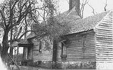
The battle was composed of three separate engagements, which may be termed the Battle of Hillsman's Farm, the Battle of Marshall's Cross Roads (or Battle of Harper's Farm), and the Battle of Lockett's Farm (or Battle of Double Bridges).[1] The Hillsman house served as a hospital for both Confederate and Union troops. Bloodstains still remain on the floor from when it served as a hospital after the battles.[5][6] The Lockett house is in its original state. The Christian house is also there.[1][3]
Areas in the NHL site include four portions of 800 acres (3.2 km2), 215 acres (0.87 km2), 5 acres (20,000 m2), and 0.6 acres (2,400 m2). These are indicated on topographical maps included in the Virginia DHR provided version of the NRHP documents.[7] Only 321 acres (1.30 km2) are covered by the current state park.
It is located on Virginia Routes 617, 618, and 619 in Farmville and Burkeville, in Amelia and Prince Edward counties in Virginia. From 1865 to the area's nomination for the National Register in 1984, the area saw little development, and remained much as it was during the battles. It was declared a National Historic Landmark in 1985.[1]
Costumed interpreters station the park throughout the year. Living history performers are active in the park during the anniversary of the battle every April.[8]
The land was originally named in the 18th century for a farmer named Saylor. During the Civil War, the name was changed to Sayler. Some official records called it Sailor, which is what the Commonwealth of Virginia uses in its name for the related park.[9]
References
- 1 2 3 4 Christopher M. Calkins (June 1984). "National Register of Historic Places Inventory-Nomination: Sayler's Creek Battlefield" (pdf). National Park Service. (includes 6 maps describing the battle) and Accompanying four photos, from 1936 (32 KB)
- ↑ National Park Service (2007-01-23). "National Register Information System". National Register of Historic Places. National Park Service.
- 1 2 "Sayler's Creek Battlefield". National Historic Landmark summary listing. National Park Service. Retrieved 2008-04-23.
- ↑ "Virginia Landmarks Register". Virginia Department of Historic Resources. Retrieved 2013-05-12.
- ↑ "Battle of Sayler's Creek site photos". Retrieved 1 June 2016.
- ↑ Yenckel, James T. (22 September 1996). "Trooping Through the Past On the Civil War Trail". Washington Post. Retrieved 8 September 2016.
- ↑ Christopher M. Calkins (June 1984). "National Register of Historic Places Inventory-Nomination: Sayler's Creek Battlefield" (pdf). National Park Service. (includes 6 maps describing the battle, and topographical maps showing the four NHL site areas)
- ↑ http://www.dcr.virginia.gov/state_parks/documents/vspguide.pdf pg.9
- ↑ "WS_FTP\csn\saylor,creek". Retrieved 1 June 2016.
External links
 Media related to Sayler's Creek Battlefield at Wikimedia Commons
- Sayler's Creek Battlefield, Amelia County, one photo at Virginia DHR

