Sauveterre-Saint-Denis
| Sauveterre-Saint-Denis | |
|---|---|
|
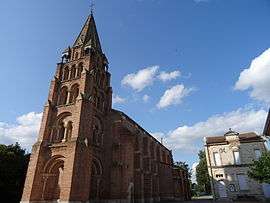
The church in Sauveterre-Saint-Denis | |
 Sauveterre-Saint-Denis | |
|
Location within Nouvelle-Aquitaine region  Sauveterre-Saint-Denis | |
| Coordinates: 44°09′19″N 0°42′27″E / 44.1553°N 0.7075°ECoordinates: 44°09′19″N 0°42′27″E / 44.1553°N 0.7075°E | |
| Country | France |
| Region | Nouvelle-Aquitaine |
| Department | Lot-et-Garonne |
| Arrondissement | Arrondissement of Agen |
| Canton | Canton of Astaffort |
| Intercommunality | Communauté de communes d'Astaffort-en-Brulhois |
| Government | |
| • Mayor (2001–2008) | René Balaguer |
| Area1 | 8.25 km2 (3.19 sq mi) |
| Population (1999)2 | 421 |
| • Density | 51/km2 (130/sq mi) |
| Time zone | CET (UTC+1) |
| • Summer (DST) | CEST (UTC+2) |
| INSEE/Postal code | 47293 / 47220 |
| Elevation |
45–53 m (148–174 ft) (avg. 53 m or 174 ft) |
|
1 French Land Register data, which excludes lakes, ponds, glaciers > 1 km² (0.386 sq mi or 247 acres) and river estuaries. 2 Population without double counting: residents of multiple communes (e.g., students and military personnel) only counted once. | |
Sauveterre-Saint-Denis is a commune in the Lot-et-Garonne department in south-western France.
See also
| Wikimedia Commons has media related to Sauveterre-Saint-Denis. |
This article is issued from Wikipedia - version of the 3/16/2015. The text is available under the Creative Commons Attribution/Share Alike but additional terms may apply for the media files.