Sargent, California
Sargent is an unincorporated community located at the Santa Clara-San Benito County border. The weight of the community is shown on the Santa Clara County, or north, side of the line. Like Rucker north of Gilroy, the name is official but not in active use by locals today. The U.S. Geological Survey lists a feature ID of 1656278 and an NAD27 latitude and longitude as 36°55′10″N 121°32′49″W / 36.919444°N 121.546944°WCoordinates: 36°55′10″N 121°32′49″W / 36.919444°N 121.546944°W. It is shown as being 150 feet above mean sea level. It appeared on 1950s Thomas Brothers maps but has dropped off the company's 21st century maps.[1][2]
The area can be easily identified by passing motorists on US 101 by the sugar beet loading conveyor along the Union Pacific Railroad track. The conveyor is west of US 101. The feature appears on a variety of railroad maps from the 1930s to present and may have been a passenger train stop at some point in history. The area is named for James P. Sargent (1823–1890) owner of the Rancho Juristac Mexican Land grant. A Sargent Hills and Sargent Creek are also located nearby to the west.
The ZIP Code is 95045 and the community is inside area code 408.
Sargent oil field
An active oil field with about 4 operating wells exists about 5.25 miles at 199 degrees off true North from the eastbound SR152 and US101 interchange. The area is called the Sargent Oil Field. The field is located on Tar Creek just north of the Santa Cruz County line. Tar Creek is sometimes called the Spanish equivalent, La Brea Creek, on some historic maps. Latitude and longitude for the oilfield are listed as 36°55′49″N 121°35′11″W / 36.93028°N 121.58639°W.[3][4]
References
- ↑ Chittenden, California, 7.5-minute quadrangle, U.S. Geological Survey, 1993.
- ↑ U.S. Geological Survey, National Geographic Names Database.
- ↑ State of California, Department of Conservation, Division of Oil, Gas, and Geothermal Resources, Map W3-10, 08/11/2003.
- ↑ Chittenden, California, 7.5-minute quadrangle, U.S. Geological Survey, 1993. The typeface identifying the oilfield on the topographic map is about six point, (very small).
External links
Municipalities and communities of Santa Clara County, California, United States | ||
|---|---|---|
| Cities and towns | 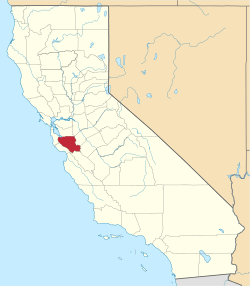 | |
| CDPs | ||
| Unincorporated communities | ||
| CCDs | ||
| Ghost towns | ||
| Bodies of water |
|  |
|---|---|---|
| Counties | ||
| Major cities | ||
| Cities and towns 100k–250k | ||
| Cities and towns 50k–99k | ||
| Cities and towns 25k-50k | ||
| Cities and towns 10k–25k |
| |
| Sub-regions | ||