Sanxia District
| Sanxia 三峽區 | |
|---|---|
| District | |
| Sanxia District | |
 | |
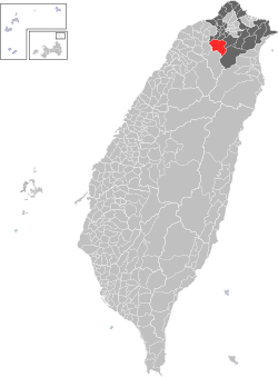 Location of Sanxia in New Taipei City | |
| Coordinates: 24°56′00″N 121°22′00″E / 24.93333°N 121.36667°ECoordinates: 24°56′00″N 121°22′00″E / 24.93333°N 121.36667°E | |
| Country | Taiwan |
| Special municipality | New Taipei City |
| Established | 1846 |
| Government | |
| • Mayor | 楊志宏[1] |
| Area | |
| • Total | 191.45 km2 (73.92 sq mi) |
| Population (January 2016) | |
| • Total | 112,775 |
| • Density | 531.9/km2 (1,378/sq mi) |
| Time zone | CST (UTC+8) |
| ZIP code | 237 |
| Area code(s) | 02 |
| Website |
www |
| Sanxia District | |||||||||||||
| Traditional Chinese | 三峽區 | ||||||||||||
|---|---|---|---|---|---|---|---|---|---|---|---|---|---|
| |||||||||||||
Sanxia District (Chinese: 三峽區; Hanyu Pinyin: Sānxiá Qū; Tongyong Pinyin: Sansiá Cyu) is an urban district in the southwestern part of New Taipei City, Taiwan. It is the second largest district in New Taipei City after Wulai District.
Name
The old name of Sanxia, Sa-kak-eng (Chinese: 三角湧; pinyin: Sānjiǎoyǒng; Pe̍h-ōe-jī: Saⁿ-kak-éng; literally: "triangular surge") refers to the meeting of the Dahan River, Sansia River, and Horizontal River. In 1920, Taiwan's Japanese government administratively designated the town as Sankyō (Japanese: 三峽, lit. Three Gorges), Kaizan District, Taihoku Prefecture.
Geography
It has an area of 191.45 km² and a population of 101,839 (May 2010).
Government institutions

Sanxia District office
Education
University
- National Taipei University Sanxia Main Campus (國立臺北大學三峽校區本部)
Senior High schools
- Mingde High school (市立明德高中)
- Tsz-Shiou Senior High school (辭修高中)
Junior High schools
- Sanxia Junior High school (市立三峽國中)
- Anxi Junior High school (市立安溪國中)
Others
- National Academy for Educational Research Preparatory office-Planning Objectives
Tourist attractions
- Zushi Temple - The most important religious site in Sanxia. Originally built in 1769 by Fukienese immigrants to Taiwan, it has been rebuilt three times, of which the last effort (beginning 1947) is the masterpiece of renown Taiwanese artist Li Mei-shu. It is considered by many to be the most intricately sculpted temple in Taiwan.
- Sanxia Old Street - A business street built during the Japanese rule, it is a very well preserved example of Japanese colonial architecture of the time. The street features stores selling art, ceramics, and local specialty foods (most notably Bull Horn Croissants).
- Historical Relic Hall (三峽區歷史文物館) - preserves artistic and cultural artifacts from Sanxia's past.
- New Taipei City Hakka Museum - the largest Hakka cultural center in Taiwan exhibiting the culture, history, and influence of the Hakka people in Taiwan and abroad.
- Li Mei-shu Memorial Gallery
- Sanxia History Museum
- National Taipei University Arts Boulevard
- Sanxia Agricultural Specialty Products Museum
- Tourism Factory of Cha-Shan-Fang Soap[2]
- Pigs of God (神豬) Contest - The largest event held at Zushi Temple around Chinese New Year where farmers compete to raise the fattest pig. The fattest pig is then sacrificed to the local Taoist god Zushi-Ye (祖師爺). Controversial to animal rights activists, Zushi Temple is one of the few places in Taiwan that still practice this tradition.[3]
- Sanxia Indigo Blue Dye Festival - A celebration of Sanxia's past as a major dyeing center in northern Taiwan.
 Walking along Minquan Old Street
 Zushi Temple
 Colonial Japanese architecture along Minquan Old Street
 Shops along Minquan Old Street
 Changfu Bridge across the Sansia River
 Street market on Changfu Bridge during Weekend
 Sanxia River viewed from Changfu Bridge
 Bull Horn Croissants, a local specialty
 Fude Temple in Sanxia
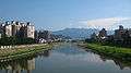 View from Changfu Bridge in Sanxia
Transportation
- Car — Sanxia is served by Freeway No. 3. (San-ying Interchange)
- Bus — Sanxia is accessible by bus from Taipei (buses 702, 703, 705, 706,939), Taoyuan District, and Yingge (Blue 19).
- Train — Although Sanxia does not have a train station, it is accessible by bus from Yingge Train Station across the river.
- MRT — Accessible via the Tucheng Line of the Taipei Metro to Yongning (永寧). Bus 916 from exit 1 connects to Sanxia on Highway 3. In addition Bus 910 leaves from Fuzhong (府中) station in Banqiao. Both routes are multi-section tickets, paying on entry or exit.
Notable natives
See also
| Wikimedia Commons has media related to Sanxia District, New Taipei. |
References
External links
- Sanxia District Government website (Chinese)
- Sanxia tourist information (English)
Districts of New Taipei | ||
|---|---|---|
City seat: Banqiao | ||
| Northern |  | |
| Eastern | ||
| Western | ||
| Southern | ||
| Mountain indigenous district | ||
Note: Although Hanyu Pinyin is the national standard, the municipal government endorses and uses "New Taipei" instead of "Xinbei" and "Tamsui" instead of "Danshui." | ||
This article is issued from Wikipedia - version of the 11/15/2016. The text is available under the Creative Commons Attribution/Share Alike but additional terms may apply for the media files.