Santarém District
| District of Santarém | |
|---|---|
| District | |
 | |
| Country | Portugal |
| Region |
Centro and Alentejo |
| Historical province |
Ribatejo (partly Beira Baixa and Beira Litoral) |
| No. of municipalities | 21 |
| No. of parishes | 193 |
| Capital | Santarém |
| Area | |
| • Total | 6,747 km2 (2,605 sq mi) |
| Population | |
| • Total | 475,344 |
| • Density | 70/km2 (180/sq mi) |
| No. of parliamentary representatives | 10 |
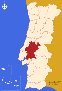
The District of Santarém (Portuguese pronunciation: [sɐ̃tɐˈɾɐ̃j], Portuguese: Distrito de Santarém) is located in Centro Region, Portugal, the district capital is the city of Santarém.
It has an area of 6747 km² (3rd largest in Portugal), and a population of 475,344 inhabitants.
Municipalities
The district includes the following 21 municipalities.
- Abrantes
- Alcanena
- Almeirim
- Alpiarça
- Benavente
- Cartaxo
- Chamusca
- Constância
- Coruche
- Entroncamento
- Ferreira do Zêzere
- Golegã
- Mação
- Ourém
- Rio Maior
- Salvaterra de Magos
- Santarém
- Sardoal
- Tomar
- Torres Novas
- Vila Nova da Barquinha
Summary of votes and seats won 1976-2011
Summary of election results from Santarém district, 1976-2011
| Parties | % | S | % | S | % | S | % | S | % | S | % | S | % | S | % | S | % | S | % | S | % | S | % | S | % | S |
|---|---|---|---|---|---|---|---|---|---|---|---|---|---|---|---|---|---|---|---|---|---|---|---|---|---|---|
| 1976 | 1979 | 1980 | 1983 | 1985 | 1987 | 1991 | 1995 | 1999 | 2002 | 2005 | 2009 | 2011 | ||||||||||||||
| PS | 38.4 | 6 | 27.3 | 3 | 30.4 | 4 | 38.4 | 5 | 18.6 | 2 | 21.7 | 3 | 29.4 | 3 | 45.8 | 5 | 45.5 | 5 | 38.4 | 4 | 46.1 | 6 | 33.7 | 4 | 25.9 | 3 |
| PSD | 19.5 | 3 | 24.7 | 3 | 27.8 | 4 | 47.9 | 7 | 49.1 | 6 | 31.0 | 3 | 30.2 | 3 | 38.1 | 4 | 26.4 | 3 | 27.0 | 3 | 37.6 | 5 | ||||
| CDS-PP | 13.9 | 2 | 10.0 | 1 | 7.7 | 1 | 3.6 | 3.3 | 8.7 | 1 | 8.1 | 1 | 8.4 | 1 | 6.9 | 11.2 | 1 | 12.3 | 1 | |||||||
| PCP/APU/CDU | 16.1 | 2 | 21.7 | 3 | 19.0 | 2 | 20.0 | 3 | 16.4 | 2 | 12.6 | 1 | 9.8 | 1 | 9.5 | 1 | 10.1 | 1 | 8.6 | 1 | 8.6 | 1 | 9.2 | 1 | 9.0 | 1 |
| BE | 2.0 | 2.8 | 6.5 | 11.8 | 1 | 5.8 | ||||||||||||||||||||
| AD | 41.0 | 6 | 42.1 | 6 | ||||||||||||||||||||||
| PRD | 23.8 | 3 | 7.3 | 1 | 1.0 | |||||||||||||||||||||
| Source: Comissão Nacional de Eleições | ||||||||||||||||||||||||||
Coordinates: 39°14′N 8°41′W / 39.233°N 8.683°W
This article is issued from Wikipedia - version of the 9/16/2015. The text is available under the Creative Commons Attribution/Share Alike but additional terms may apply for the media files.