Santa Maria da Feira
| Santa Maria da Feira | |||
|---|---|---|---|
| Municipality | |||
 | |||
| |||
 | |||
| Coordinates: 40°56′N 8°32′W / 40.933°N 8.533°WCoordinates: 40°56′N 8°32′W / 40.933°N 8.533°W | |||
| Country |
| ||
| Region | Norte | ||
| Subregion | Entre Douro e Vouga | ||
| Metropolitan area | Porto | ||
| District | Aveiro | ||
| Parishes | 21 | ||
| Government | |||
| • President | Emídio Sousa (PSD) | ||
| Area | |||
| • Total | 215.88 km2 (83.35 sq mi) | ||
| Population (2011) | |||
| • Total | 139,309 | ||
| • Density | 650/km2 (1,700/sq mi) | ||
| Time zone | WET/WEST (UTC+0/+1) | ||
| Website | https://www.cm-feira.pt/portal/site/cm-feira | ||

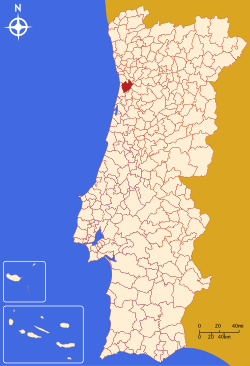
Santa Maria da Feira (Portuguese pronunciation: [ˈsɐ̃tɐ mɐˈɾi.ɐ ðɐ ˈfejɾɐ]) is a city and a municipality in Aveiro District in Portugal. The population in 2011 was 139,309,[1] in an area of 215.88 km².[2]
History

Santa Maria is located in area that allowed it to be a crossroads of various peoples. Ancient Roman roadways connected Porto, Viseu, Lisbon and Braga and intersected the region, and was used until the 19th century. In addition, pre-Roman castros dotted the territory.
Eventually, nomadic tribes began to settle in the vicinity of the castle and began to sell various products (salt, implements, tools and agricultural products). This settlement soon became known as the Terra de Santa Maria. This name first appeared in 1117, in a donation by D. Teresa, who began to reside in the castle around 1120 (many of the documents associated with the name started appearing from this time, including various funeral documents already existed in the 4th and 5th century. The lands of Santa Maria included a vast territory that included not only the municipality of Feira, but also Ovar, Vila Nova de Gaia, Vale de Cambra and São João da Madeira, among others.
The castle of Santa Maria da Feira, the ex-libris of Feira, is a testament to the military architecture of the Middle Ages. It is the fulcrum of the history of the region, and an important point in the Reconquista.
In the time of king Denis of Portugal, Feira already was the see of a julgado (old administrative division). This is testified by an ancient document called Foral Velho. It was awarded a new foral in 1514, when Manuel I of Portugal was the King of Portugal.
Geography
|
|
The municipality includes several towns (vilas) and 3 cities (cidades): Santa Maria da Feira, Fiães and Lourosa. It is the most populous municipio in Entre Douro e Vouga and it is part of the Greater Metropolitan Area of Porto.
Administratively, the municipality is divided into 21 civil parishes (freguesias):[3]
- Argoncilhe
- Arrifana
- Caldas de São Jorge e Pigeiros
- Canedo, Vale e Vila Maior
- Escapães
- Fiães
- Fornos
- Lobão, Gião, Louredo e Guisande
- Lourosa
- Milheirós de Poiares
- Mozelos
- Nogueira da Regedoura
- Paços de Brandão
- Rio Meão
- Romariz
- Sanguedo
- Santa Maria da Feira, Travanca, Sanfins e Espargo
- Santa Maria de Lamas
- São João de Ver
- São Paio de Oleiros
- São Miguel do Souto e Mosteirô
International relations
Santa Maria da Feira Municipality is twinned with:
 Joué-lès-Tours, France, since December 1989
 Targovishte, Bulgaria[4]
 Catió, Guinea-Bissau
Economy
Santa Maria da Feira is a heavily industrialized municipality and is famous for its several cork transforming and shoe factories. The town is the headquarters of Amorim corporation. The seat of the municipality is Feira, famous for its medieval castle which was the residence of Portugal's first king, Afonso Henriques, for a short period of time. The castle, located at the top of a hill, was of considerable strategic importance during its time.
Every year, in summer, a medieval festival takes place in Santa Maria da Feira - the Feira Medieval - during which the city goes back to the Middle Ages.
Architecture
Municipality's sights include the Convento do Espírito Santo (convent), the Igreja da Misericórdia (church; 18th century), and the Rua Direita (street; 18th and 19th century architecture). However, its greatest landmark is the castelo Santa Maria da Feira Castle, from the 11th century.
Culture


The municipal holiday is January 20. It's the day when the whole municipality celebrates the Fogaceiras. The Fogaceiras is a special local holiday. During the Middle Ages, the lands of Santa Maria (as it was known back then) were infested by the dark plague. To get rid of this calamity, the locals offered a sweet roll, called fogaça, to the patron saint Saint Sebastien. The Fogaceiras have been celebrated for five hundred years, since the eradication of the dark plague.
The municipality has a science museum, the Visionarium.
References
- ↑ Instituto Nacional de Estatística (INE), Census 2011 results according to the 2013 administrative division of Portugal
- ↑ Direção-Geral do Território
- ↑ Diário da República. "Law nr. 11-A/2013, pages 552 106-107" (pdf) (in Portuguese). Retrieved 30 July 2014.
- ↑ "International Contacts". Targovishte Municipality. Retrieved 2013-08-29.
External links
- Feirense web
- Info at the Portuguese Association of Municipalities website
- Photos from Santa Maria da Feira
- More pictures of Santa Maria da Feira