Santa Josefa, Agusan del Sur
| Santa Josefa | |
|---|---|
| Municipality | |
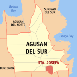 Location within Agusan del Sur province | |
.svg.png) Santa Josefa Location within the Philippines | |
| Coordinates: 7°59′N 126°02′E / 7.98°N 126.03°ECoordinates: 7°59′N 126°02′E / 7.98°N 126.03°E | |
| Country | Philippines |
| Region | Caraga (Region XIII) |
| Province | Agusan del Sur |
| District | 2nd district of Agusan del Sur |
| Barangays | 11 (see Barangays) |
| Government [1] | |
| • Type | Sangguniang Bayan |
| • Mayor | Jann Roby R. Otero |
| Area[2] | |
| • Total | 341.8 km2 (132.0 sq mi) |
| Population (2015 census)[3] | |
| • Total | 26,729 |
| • Density | 78/km2 (200/sq mi) |
| • Voter (2016)[4] | 17,085 |
| Time zone | PST (UTC+8) |
| ZIP code | 8512 |
| IDD : area code | +63 (0)85 |
| Income class | 3rd class |
| PSGC | 160310000 |
Santa Josefa, officially the Municipality of Santa Josefa (Filipino: Bayan ng Santa Josefa), is a municipality in the province of Agusan del Sur in the Caraga (Region XIII) of the Philippines. The population was 26,729 at the 2015 census.[3] In the 2016 election, it had 17,085 registered voters.[4]
Geography
Santa Josefa is located at 7°59′N 126°02′E / 7.98°N 126.03°E.
According to the Philippine Statistics Authority, the municipality has a land area of 341.8 square kilometres (132.0 sq mi)[2] constituting 3.42% of the 9,989.52-square-kilometre- (3,856.98 sq mi) total area of Agusan del Sur.
Climate
Santa Josefa is classified as Type II climate which has no dry season but with pronounced maximum rain period occurring from December to January.[5]
| Climate data for Santa Josefa | |||||||||||||
|---|---|---|---|---|---|---|---|---|---|---|---|---|---|
| Month | Jan | Feb | Mar | Apr | May | Jun | Jul | Aug | Sep | Oct | Nov | Dec | Year |
| Average high °C (°F) | 29.6 (85.3) |
30.0 (86) |
30.8 (87.4) |
31.6 (88.9) |
32.0 (89.6) |
32.2 (90) |
32.3 (90.1) |
32.5 (90.5) |
32.5 (90.5) |
32.2 (90) |
31.2 (88.2) |
30.6 (87.1) |
31.46 (88.63) |
| Average low °C (°F) | 23.4 (74.1) |
23.2 (73.8) |
23.6 (74.5) |
24.2 (75.6) |
24.4 (75.9) |
24.3 (75.7) |
24.1 (75.4) |
24.3 (75.7) |
24.1 (75.4) |
24.0 (75.2) |
23.9 (75) |
23.7 (74.7) |
23.93 (75.08) |
| Average rainy days | 24 | 21 | 20 | 19 | 16 | 16 | 14 | 14 | 14 | 17 | 17 | 21 | 213 |
| Source: Storm247[6] | |||||||||||||
Barangays
Santa Josefa is politically subdivided into 11 barangays.[7]
| PSGC | Barangay | Population | ±% p.a. | ||
|---|---|---|---|---|---|
| 2015[3] | 2010[8] | ||||
| 160310001 | Angas | 12.2% | 3,271 | 3,119 | +0.91% |
| 160310002 | Aurora | 9.9% | 2,651 | 2,396 | +1.94% |
| 160310003 | Awao | 8.4% | 2,232 | 2,232 | 0.00% |
| 160310010 | Concepcion | 3.9% | 1,055 | 898 | +3.12% |
| 160310011 | Pag-asa | 4.2% | 1,122 | 923 | +3.79% |
| 160310005 | Patrocinio | 8.4% | 2,238 | 2,182 | +0.48% |
| 160310006 | Poblacion | 18.6% | 4,962 | 4,783 | +0.70% |
| 160310007 | San Jose | 9.3% | 2,486 | 2,315 | +1.37% |
| 160310008 | Santa Isabel | 8.8% | 2,363 | 2,293 | +0.57% |
| 160310009 | Sayon | 9.8% | 2,620 | 2,368 | +1.94% |
| 160310004 | Tapaz | 6.5% | 1,729 | 1,647 | +0.93% |
| Total | 26,729 | 25,156 | +1.16% | ||
Demographics
| Population census of Santa Josefa | |||||||||||||||||||||||||
|---|---|---|---|---|---|---|---|---|---|---|---|---|---|---|---|---|---|---|---|---|---|---|---|---|---|
|
| ||||||||||||||||||||||||
| Source: PSA[3][8][9] | |||||||||||||||||||||||||
In the 2015 census, Santa Josefa had a population of 26,729.[3] The population density was 78 inhabitants per square kilometre (200/sq mi).
In the 2016 election, it had 17,085 registered voters.[4]
Economy
Santa Josefa's main products are rice and corn.[10]
References
- ↑ "Municipality". Quezon City, Philippines: Department of the Interior and Local Government. Retrieved 31 May 2013.
- 1 2 "Province: Agusan del Sur". PSGC Interactive. Makati City, Philippines: Philippine Statistics Authority. Retrieved 28 October 2016.
- 1 2 3 4 5 "CARAGA". Census of Population (2015): Total Population by Province, City, Municipality and Barangay (Report). PSA. Retrieved 20 June 2016.
- 1 2 3 "2016 National and Local Elections Statistics". Commission on Elections. 2016.
- ↑ "Municipality of Sta. Josefa". Province of Agusan del Sur. Provincial Information Management Office (PIMO). Archived from the original on 19 October 2016. Retrieved 19 October 2016.
- ↑ "Weather forecast for Santa Josefa". Storm247.com. StormGeo AS, Nordre Nøstekaien 1, N-5011 Bergen, Norway: StormGeo AS. Retrieved 19 October 2016.
- ↑ "Municipal: Santa Josefa, Agusan del Sur". PSGC Interactive. Quezon City, Philippines: Philippine Statistics Authority. Retrieved 8 January 2016.
- 1 2 "CARAGA". Census of Population and Housing (2010): Total Population by Province, City, Municipality and Barangay (Report). NSO. Retrieved 29 June 2016.
- ↑ "CARAGA". Census of Population (1995, 2000 and 2007): Total Population by Province, City and Municipality (Report). NSO. Archived from the original on 11 November 2011.
- ↑ "Sta. Josefa". Department of the Interior and Local Government - Region XIII - Caraga Administrative Region. 18 March 2013. Archived from the original on 12 April 2015. Retrieved 19 October 2016.
 |
Bunawan | | ||
| Veruela | |
Trento | ||
| ||||
| | ||||
| Monkayo, Compostela Valley |
Prosperidad (capital) | |
| Municipalities | |
| Component city | |