Santa Fe Springs, California
| Santa Fe Springs, California | ||
|---|---|---|
| City | ||
| City of Santa Fe Springs | ||
|
Little Lake Park, Santa Fe Springs | ||
| ||
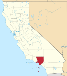
 Location of Santa Fe Springs in Los Angeles County, California | ||
 Santa Fe Springs, California Location in the United States | ||
| Coordinates: 33°56′15″N 118°4′2″W / 33.93750°N 118.06722°WCoordinates: 33°56′15″N 118°4′2″W / 33.93750°N 118.06722°W | ||
| Country |
| |
| State |
| |
| County |
| |
| Incorporated | May 15, 1957[1] | |
| Government | ||
| • Mayor | Richard J. Moore[2] | |
| Area[3] | ||
| • Total | 8.914 sq mi (23.088 km2) | |
| • Land | 8.874 sq mi (22.985 km2) | |
| • Water | 0.040 sq mi (0.103 km2) 0.45% | |
| Elevation[4] | 135 ft (41 m) | |
| Population (2010) | ||
| • Total | 16,223 | |
| • Density | 1,800/sq mi (700/km2) | |
| Time zone | Pacific (UTC-8) | |
| • Summer (DST) | PDT (UTC-7) | |
| ZIP codes | 90605, 90670, 90671 | |
| Area code | 562 | |
| FIPS code | 06-69154 | |
| GNIS feature ID | 1661404 | |
| Website |
www | |


Santa Fe Springs is a city in Los Angeles County, California, United States. It is one of the Gateway Cities of southeast Los Angeles County. The population was 16,223 at the 2010 census, down from 17,438 at the 2000 census.
Geography
Santa Fe Springs is located at 33°56′15″N 118°04′02″W / 33.937443°N 118.067155°W.[5]
According to the United States Census Bureau, the city has a total area of 8.9 square miles (23 km2). 8.9 square miles (23 km2) of it is land and 0.04 square miles (0.10 km2) of it (0.45%) is water.
It is bordered by the unincorporated West Whittier-Los Nietos to the north, Pico Rivera to the northwest, Downey to the west, Norwalk to the southwest, Cerritos to the south, La Mirada and the unincorporated South Whittier to the east, and Whittier to the northeast.
History
In 1907, the Union Oil Company of California began drilling near the intersection of Norwalk Blvd. and Telegraph Road, locally known as "Four Corners," with the spudding in of the Meyer No. 1 well. That well, and a subsequent one, failed. In 1921 the Union-Bell well blew in as a 2,500-barrel gusher and set off an oil rush by major oil companies and fly-by-night producers. Within a year the Santa Fe Springs oil field was considered one of the richest pools in petroleum history. Santa Fe Springs became a promoters' paradise. Prospective investors were bused into the field, served a free lunch in circus tents, and told stories about the fortunes made in oil. In 1923 the state legislature limited the amount of stock that could be sold in a well.
In the 1920s the field produced as much as 345,000 barrels daily, exceeding production at Signal Hill and Huntington Beach. Production slowed as the decade went on, and by 1928 the Wilshire Oil Company was drilling in deep sand levels. Production levels dropped each year from then on, but by 1938 the field had yielded a total of more than 440,000,000 barrels of oil.[6]
Santa Fe Springs is the birthplace of the Shelby Cobra. In 1962 Carroll Shelby set up shop in Dean Moon's speed shop in Santa Fe Springs. Shelby had AC Cars of Surrey, England ship cars without a motor or drive train to the Santa Fe shop. Shelby shoe-horned a 260-cubic-inch V8 into the tiny, lightweight British roadster and the Cobra was born: a British sports car with American hot rod power.
Demographics
| Historical population | |||
|---|---|---|---|
| Census | Pop. | %± | |
| 1960 | 16,342 | — | |
| 1970 | 14,750 | −9.7% | |
| 1980 | 14,520 | −1.6% | |
| 1990 | 15,520 | 6.9% | |
| 2000 | 17,438 | 12.4% | |
| 2010 | 16,223 | −7.0% | |
| Est. 2015 | 18,026 | [7] | 11.1% |
2010
The 2010 United States Census[9] reported that Santa Fe Springs had a population of 16,223. The population density was 1,819.9 people per square mile (702.7/km²). The racial makeup of Santa Fe Springs was 9,514 (58.6%) White (11.9% Non-Hispanic White),[10] 371 (2.3%) African American, 233 (1.4%) Native American, 677 (4.2%) Asian, 31 (0.2%) Pacific Islander, 4,712 (29.0%) from other races, and 685 (4.2%) from two or more races. Hispanic or Latino of any race were 13,137 persons (81.0%).
The Census reported that 16,030 people (98.8% of the population) lived in households, 85 (0.5%) lived in non-institutionalized group quarters, and 108 (0.7%) were institutionalized.
There were 4,747 households, out of which 2,093 (44.1%) had children under the age of 18 living in them, 2,354 (49.6%) were opposite-sex married couples living together, 965 (20.3%) had a female householder with no husband present, 368 (7.8%) had a male householder with no wife present. There were 286 (6.0%) unmarried opposite-sex partnerships, and 26 (0.5%) same-sex married couples or partnerships. 894 households (18.8%) were made up of individuals and 526 (11.1%) had someone living alone who was 65 years of age or older. The average household size was 3.38. There were 3,687 families (77.7% of all households); the average family size was 3.84.
The population was spread out with 4,286 people (26.4%) under the age of 18, 1,770 people (10.9%) aged 18 to 24, 4,272 people (26.3%) aged 25 to 44, 3,735 people (23.0%) aged 45 to 64, and 2,160 people (13.3%) who were 65 years of age or older. The median age was 35.3 years. For every 100 females there were 93.0 males. For every 100 females age 18 and over, there were 90.0 males.
There were 4,976 housing units at an average density of 558.2 per square mile (215.5/km²), of which 2,894 (61.0%) were owner-occupied, and 1,853 (39.0%) were occupied by renters. The homeowner vacancy rate was 2.1%; the rental vacancy rate was 5.5%. 10,323 people (63.6% of the population) lived in owner-occupied housing units and 5,707 people (35.2%) lived in rental housing units.
According to the 2010 United States Census, Santa Fe Springs had a median household income of $54,081, with 9.1% of the population living below the federal poverty line.[10]
2000
As of the census[11] of 2000, there were 17,438 people, 4,834 households, and 3,780 families residing in the city. The population density was 1,992.0 inhabitants per square mile (769.5/km²). There were 4,933 housing units at an average density of 563.5 per square mile (217.7/km²). The racial makeup of the city was 51.22% White, 3.89% African American, 1.43% Native American, 3.95% Asian, 0.20% Pacific Islander, 34.99% from other races, and 4.31% from two or more races. Hispanic or Latino of any race were 71.38% of the population.
As of 2000, speakers of Spanish as their first language accounted for 51.63% of residents, while English was spoken by 46.07%, Tagalog was spoken by 1.05%, Vietnamese was spoken by 0.68%, Korean was spoken by 0.37%, French by 0.17% of the population.[12]
There were 4,834 households out of which 38.3% had children under the age of 18 living with them, 54.0% were married couples living together, 18.1% had a female householder with no husband present, and 21.8% were non-families. 18.3% of all households were made up of individuals and 11.2% had someone living alone who was 65 years of age or older. The average household size was 3.35 and the average family size was 3.82.
In the city the population was spread out with 29.1% under the age of 18, 9.4% from 18 to 24, 29.7% from 25 to 44, 19.1% from 45 to 64, and 12.8% who were 65 years of age or older. The median age was 33 years. For every 100 females there were 100.1 males. For every 100 females age 18 and over, there were 97.4 males.
The median income for a household in the city was $44,540, and the median income for a family was $49,867. Males had a median income of $33,413 versus $27,279 for females. The per capita income for the city was $14,547. About 8.0% of families and 12.5% of the population were below the poverty line, including 13.9% of those under age 18 and 7.6% of those age 65 or over.
Government
In the California State Legislature, Santa Fe Springs is in the 32nd Senate District, represented by Democrat Tony Mendoza, and in the 57th Assembly District, represented by Democrat Ian Calderon.[13]
In the United States House of Representatives, Santa Fe Springs is in California's 38th congressional district, represented by Democrat Linda Sánchez.[14]
Emergency services
Police services for the city are contracted to the Whittier Police Department, based at the Santa Fe Springs Police Services Center sub-station.[15] The police services center is located on Telegraph Road.
Fire protection in the city is provided by the Santa Fe Springs Department of Fire-Rescue with ambulance transport by Care Ambulance Service. There are 4 fire stations in Santa Fe Springs. The headquarters fire station is located on Greenstone Avenue south of Lakeland Boulevard, and also the home of the Rio Hondo Fire Academy.
Economy
.jpg)
The economy of Santa Fe Springs is largely made up of light industry, unlike its neighboring cities. This is evident when looking at satellite and aerial photography, where the majority of the city is distinguishable from its neighboring cities, due to the density of very large, industrial and manufacturing facilities.
Santa Fe Springs is home to Egge Machine Company,[16] supplier of Cadillac engine parts for custom cars and hot rods and also is home to U.S. Aerospace, a publicly traded aerospace and defense contractor for the USDoD, USAF, Lockheed Martin Corporation, The Boeing Company, L-3 Communications Holdings, the Middle River Aircraft Systems subsidiary of General Electric Company, and other aircraft manufacturers, aerospace companies, and defense contractors.[17]
The Hathaway Ranch Museum in Santa Fe Springs houses an extensive collection of early ranching and farming equipment, as well as oil field machinery. The museum traces five generations of the Hathaway family and is a reflection of the economic transition of the region.[18][19]
Top employers
According to the City's 2010 Comprehensive Annual Financial Report, the top employers in the city are:[20]
| # | Employer | # of Employees |
|---|---|---|
| 1 | Vons | 858 |
| 2 | McMaster-Carr | 644 |
| 3 | Presto Food Products | 492 |
| 4 | Shaw Industries | 379 |
| 5 | L. A. Specialty Produce Company | 356 |
| 6 | Southern Wine & Spirits | 339 |
| 7 | Motran | 321 |
| 8 | Trojan Battery | 311 |
| 9 | Walmart | 300 |
| 10 | Vance & Hines | 283 |
Sections
- Carmenita
Sister cities
References
- ↑ "California Cities by Incorporation Date" (Word). California Association of Local Agency Formation Commissions. Retrieved August 25, 2014.
- ↑ "Mayor". Santa Fe Springs. Retrieved February 23, 2015.
- ↑ "2010 Census U.S. Gazetteer Files – Places – California". United States Census Bureau.
- ↑ "Santa Fe Springs". Geographic Names Information System. United States Geological Survey. Retrieved February 26, 2015.
- ↑ "US Gazetteer files: 2010, 2000, and 1990". United States Census Bureau. February 12, 2011. Retrieved April 23, 2011.
- ↑ Work Project Administration, "Los Angeles". Hastings House, 1941, pp. 337-338.
- ↑ "Annual Estimates of the Resident Population for Incorporated Places: April 1, 2010 to July 1, 2015". Retrieved July 2, 2016.
- ↑ "Census of Population and Housing". Census.gov. Retrieved June 4, 2015.
- ↑ "2010 Census Interactive Population Search: CA - Santa Fe Springs city". U.S. Census Bureau. Retrieved July 12, 2014.
- 1 2 "Santa Fe Springs (city) QuickFacts from the US Census Bureau". census.gov.
- ↑ "American FactFinder". United States Census Bureau. Retrieved January 31, 2008.
- ↑ "Data Center Results - Santa Fe Springs, California]". Modern Language Association. Retrieved November 18, 2009.
- ↑ "Statewide Database". UC Regents. Retrieved December 15, 2014.
- ↑ "California's 38th Congressional District - Representatives & District Map". Civic Impulse, LLC.
- ↑ Archived January 14, 2011, at the Wayback Machine.
- ↑ For instance, Street Rodder, 12/98, p.39.
- ↑ "usaerospace.com". usaerospace.com.
- ↑ "It's an original," Long Beach Press-Telegram, July 26, 1999.
- ↑ "Museum shows early life in city," Long Beach Press-Telegram, March 26, 2005.
- ↑ City of Santa Fe Springs CAFR
External links
| Wikimedia Commons has media related to Santa Fe Springs, California. |
- Official website
- The Clarke Estate and other Historical Points of Interest Summary of all Santa Fe Springs cultural landmarks.
- Hathaway Ranch Museum Museum with great exhibits of early California ranch life and the oil boom of the 20's and 30's.
- Heritage Park A park with authentic Tongva Native American village, ranch home, and train depot complete with locomotive.
 |
Pico Rivera | West Whittier-Los Nietos | Whittier | |
| Pico Rivera Downey Norwalk |
|
South Whittier La Mirada | ||
| ||||
| | ||||
| Norwalk | Cerritos | La Mirada |