Santa Elisabetta
| Santa Elisabetta | |
|---|---|
| Comune | |
| Comune di Santa Elisabetta | |
 | |
 Santa Elisabetta Location of Santa Elisabetta in Italy | |
| Coordinates: 37°26′N 13°33′E / 37.433°N 13.550°ECoordinates: 37°26′N 13°33′E / 37.433°N 13.550°E | |
| Country | Italy |
| Region | Sicily |
| Province / Metropolitan city | Province of Agrigento (AG) |
| Area | |
| • Total | 16.2 km2 (6.3 sq mi) |
| Elevation | 457 m (1,499 ft) |
| Population (Dec. 2004) | |
| • Total | 2,906 |
| • Density | 180/km2 (460/sq mi) |
| Demonym(s) | Elisabettesi (o sabettesi) |
| Time zone | CET (UTC+1) |
| • Summer (DST) | CEST (UTC+2) |
| Postal code | 92020 |
| Dialing code | 0922 |
Santa Elisabetta (Sicilian: Sabbetta) is a small town (municipality) in the Province of Agrigento in the Italian region Sicily, located about 80 kilometres (50 mi) south of Palermo and about 13 kilometres (8 mi) north of Agrigento. As of 31 December 2004, it had a population of 2,906 and an area of 16.2 square kilometres (6.3 sq mi).[1]
Santa Elisabetta borders the following municipalities: Aragona, Joppolo Giancaxio, Raffadali, Sant'Angelo Muxaro.
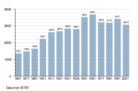
Demographic evolution
References
This article is issued from Wikipedia - version of the 1/31/2015. The text is available under the Creative Commons Attribution/Share Alike but additional terms may apply for the media files.