Santa Bárbara (canton)
| Santa Bárbara | |||
|---|---|---|---|
| Canton | |||
|
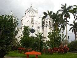
Central Church, City of Santa Bárbara, Santa Bárbara Cantón | |||
| |||
 Santa Bárbara Location within Costa Rica | |||
| Coordinates: 10°02′10″N 84°09′40″W / 10.03611°N 84.16111°WCoordinates: 10°02′10″N 84°09′40″W / 10.03611°N 84.16111°W | |||
| Country |
| ||
| Founded | ca. 1885 | ||
| Districts |
List
| ||
| Area | |||
| • Metro | 53.21 km2 (20.54 sq mi) | ||
| Elevation | 1,170 m (3,840 ft) | ||
| Population (2014 projections based on 2011 Census) | |||
| • Canton | 37,428 | ||
| • Density | 659/km2 (1,710/sq mi) | ||
| • Demonym | Santa Bárbareño/a | ||
| Time zone | Central Standard Time (UTC-6) | ||
| Area code(s) | + 506 | ||
| Website | www.munisantabarbara.go.cr | ||
.svg.png)
Santa Bárbara is the fourth canton in the province of Heredia in Costa Rica. The canton covers an area of 53.21 km²,[1] and has a population of 33,514. The capital city of the canton is also called Santa Bárbara.
Geography and administrative division
The elongated canton begins midway between the cities of Alajuela and Heredia, where the Río Segundo marks its southern boundary. It climbs through foothills northward to the Río Desengaño high in the Cordillera Central (Central Mountain Range).
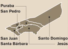
Santa Bárbara is divided into six districts:
| District Name | Neighborhoods | Latitude and Longitude | Square Kilometers | 2008 Population | Elevation |
|---|---|---|---|---|---|
| Santa Bárbara | Trompezón | 10°02'18"N, 84°09'38"W | 1.29 | 6,995 | 1,140m |
| San Pedro | Betania, Rosales (part of) | 10°01'51"N, 84°10'21"W | 2.48 | 4,149 | 1,080m |
| San Juan | San Juan Arriba, San Juan Abajo | 10°01'16"N, 84°09'51"W | 4.43 | 6,396 | 1,045m |
| Jesús (Barrio Jesús) | Altagracia, Birrí, Catalina, Común, Cuesta Colorada, Guachipelines, Guaracha, Ulises | 10°02'33"N, 84°08'50"W | 12.61 | 8,485 | 1,160m |
| Santo Domingo (El Roble) | Amapola, Cartagos, Chagüite, Giralda, Guarai, Tranquera | 10°04'36"N, 84°09'24"W | 26.24 | 3,051 | 1,396m |
| Purabá (Zetillal) | Bosconia, Marías, San Bosco, Lajas, Calle Quirós | 10°03'10"N, 84°09'30"W | 6.16 | 3,898 | 1,240m |
| Source: [2] | |||||
History
History section translated from Spanish Wikipedia Santa Bárbara was originally populated by the Huetares, who lived in the Barva region.[3] When the Spanish settled, the Huetares were forced to work on Spanish haciendas where many crops were produced, including corn, beans, legumes, cotton, sugarcane, and sarsaparilla.[3]
While looking for an outlet to the Caribbean Sea, Joaquín Mora Fernández (not to be confused with the future president), conducted the first documented European explorations of the area.[4] Mora Fernández established a base within the general area of the canton.[4]
The first haciendas in the area are dated to January 19, 1663, when Joseph Sandoval Ocampo, among others, was given a farming and pasture concession from the capital city of Cartago.[4]
By the time Alajuela was founded in 1782, the present district of San Pedro, which were then collectively called Targuás or Targuases, are mentioned. At the time, there were seventy-six men and sixteen women in Targuás.[2]
The name of the San Pedro district name is mentioned in 1819, according to a government document that states Juan Pablo Lara purchased land in the district on which to build a home and a farm.[3]
Two years later, Churruca (also known as Surruco) is mentioned in documents from 1821. Churruca was the name of the Santa Bárbara canton before it took the current name.[2]
According to a local legend, Santa Bárbara was chosen for the region’s patron saint because a resident bought an image of Saint Barbara from a Franciscan and made an altar in her home. During a terrible rainy season in Santa Bárbara, Saint Barbara heard the prayers of the resident. Little by little, her neighbors became convinced of that Saint Barbara was answering her prayers.
The canton was established by a government resolution of October 3, 1855.[2]
Some of the early residents of Santa Bárbara include Ambrose Arias, Juan Cortez, Andres Murillo, Gregory Cuadra, Salvador Sanchez, Jose Maria Palma, Juan Bastos, Victorio Cortes, Joaquin Gutierrez, Jose Angel Sanchez, Jose Dolores Gonzalez and Diego Murillo.
It is unknown when coffee production began in Santa Bárbara. Shortly after 1842, resident Víctor Aguilar started the first coffee farm in the canton at "El Paso del Guayabo" ("Guayabo Steps"), followed by José Zamora in the Porrosati River lowlands. The first harvests were processed in San Joaquín, and it soon became the most important crop of the canton.[5]
By 1846, there were four major districts of Santa Bárbara.[2] There were 1,500 residents, with 1,000 living in San Pedro. In 1854, the site of the first church was chosen because it was in the center of the four major areas. The first church is presumed to have been located two blocks south of where the current Santa Bárbara Church is.
The most infamous resident of Santa Bárbara, where he was born and later died, was Beltrán Dalay Cortés Carvajal. Cortés Carvajal murdered two doctors who had performed a surgery on him ten years before.
Demographics
As of 2008, there were 33,514 citizens in the entire canton.[2] Jesús was the most populous with 8,791 residents.[2] 58% of the population lived in areas marked as rural, while 42% lived in urban areas.[2] 15% of residents seeking employment were unemployed,[2] while 68% of residents worked in agriculture.[5]
Population growth has placed strains on infrastructure, such as the quality of roads.[2] Should its population growth continue, the canton is expected to have a population of 41,725 in 2030.[2]
The canton has one of the highest standards of living in country as determined by the Human Development Index.[6] The same index, however, ranks Santa Bárbara as one of the twenty least secure cantons.
According to the United Nations, Santa Bárbara has a literacy rate of 98.4.[7] 100% of elementary-age children and 74.8% of secondary-age children are enrolled in school.
Education and community organizations
Within the canton of Santa Bárbara , there are many different community service organizations. Such groups include a Red Cross committee, nine Alcoholics Anonymous groups, six sports committees, twelve local health committees, nine local church committees, a Lions Clubs International branch, a public library, and organizations for senior citizens.[8] In addition, the Municipality and Ministry of Health maintain community outreach programs.[8]
Within the canton, there are fifteen public and three private elementary schools. There are three high schools, including Liceo de Santa Bárbara, and Liceo el Roble.[8]
Like most of Costa Rica, the church with the largest following is the Catholic Church. There are numerous churches within the district, organized by Eucharistic communities, reading groups, youth groups, and so forth. In addition, there are several Protestant churches, including two churches for Jehovah's Witnesses.
Sports
Volleyball
The municipality is also home to the Asociación Deportiva Barbareña de Voleibol (ASBAVOL) (Santa Bárbara Volleyball Sports Association), one of the country's most successful volleyball clubs.[9] The clube began in 1992,[10] winning numerous championships and tournaments in different categories.[10][11] ASBAVOL players regularly join the Costa Rica women's national volleyball team.
Soccer
Santa Bárbara has an active sporting community. Beginning in 1943, Club Sport Barbareño represented Santa Bárbara in the first division of the national soccer league. The team changed its name to Asociación Deportiva Barbareña (Bárbara Sports Association) in 1984. The team plays within the national Costa Rican soccer hierarchy. Between 1962 and 1975, it was a third division team. Between 1975 and 1981, as well as 1993 and 1997, it was a second division team. Between 1997 and 2004, it was a first division team. It currently plays in the third division at the Carlos Alvarado Villalobos Stadium in Santa Bárbara, which holds 1,500 spectators.
Another team from San Pedro de Santa Bárbara, Asociación Deportiva Fraternidad de Santa Bárbara, played within the third and second divisions beginning in 1947 until its disintegration in the late 1990s.
Geology
The Santa Bárbara cantón is constructed largely of volcanic rock from the Holocene Period of the Cenozoic Era. The fluvial system of Santa Bárbara generally flows toward the Pacific Ocean via the Rio Grande de Tarcoles river basin. The Santa Bárbara cantón forms part of the larger Origen Volcánico geomorphic region, including the sub-units of Volcán Barva and the Central Valley's Relleno Volcánico.
References
- ↑ Instituto Geográfico Nacional (IGN), 2001.
- 1 2 3 4 5 6 7 8 9 10 11 Plan de Desarrollo Humano Local 2010-2020, Cantón Santa Bárbara (in Spanish). Proyecto de Fortalecimiento Municipal y Descentralización. August 2009. p. 17. Retrieved 27 May 2014.
- 1 2 3 "Reseña Histórica del Cantón". Municipalidad de Santa Bárbara (in Spanish). 2010. Retrieved 23 May 2014.
- 1 2 3 Hernández Vargas, Rose Marie (6 November 2013). "Reseña histórica de Santa Bárbara de Heredia". UNED: Extensión en acción (in Spanish). Retrieved 28 May 2014.
- 1 2 Plan de Desarrollo Humano Local 2010-2020, Cantón Santa Bárbara (in Spanish). Proyecto de Fortalecimiento Municipal y Descentralización. August 2009. p. 28. Retrieved 27 May 2014.
- ↑ Vindes, Leticia (27 October 2011). "Heredia concentra las mejores oportunidades, pero falla en seguridad". El Financiero (in Spanish). San Jose. Retrieved 23 May 2014.
- ↑ Atlas del desarrollo humano cantonal de Costa Rica 2011 (PDF) (in Spanish). San José: Programa de las Naciones Unidas para el Desarrollo PNUD. 2011. ISBN 978-9968-794-58-9. Retrieved 23 May 2014.
- 1 2 3 Plan de Desarrollo Humano Local 2010-2020, Cantón Santa Bárbara (in Spanish). Proyecto de Fortalecimiento Municipal y Descentralización. August 2009. p. 17. Retrieved 27 May 2014.
- ↑ Luis Rodríguez C., Jose (7 March 2014). "Atenas será el rival de Santa Bárbara en la final del voleibol femenino". La Nacion (Costa Rica) (in Spanish). San Jose. Retrieved 16 April 2014.
- 1 2 ASBAVOL.org: Historia, Retrieved: 22 May 2014
- ↑ Araya N., José Fernando (8 March 2014). "Santa Bárbara alcanzó el tricampeonato del voleibol femenino al derrotar a Atenas". La Nacion (in Spanish). San Jose. Retrieved 22 May 2014.
External links
- Santa Bárbara: El Sitio Oficial del Gobierno Local, official local government site