San Rafael, New Mexico
| San Rafael | |
|---|---|
| Census-designated place | |
 San Rafael Location in the United States | |
| Coordinates: 35°6′45″N 107°52′57″W / 35.11250°N 107.88250°WCoordinates: 35°6′45″N 107°52′57″W / 35.11250°N 107.88250°W | |
| Country | United States |
| State | New Mexico |
| County | Cibola |
| Population (2010) | |
| • Total | 933 |
| Time zone | Mountain (MST) (UTC-7) |
| • Summer (DST) | MDT (UTC-6) |
San Rafael is a census-designated place (CDP) in Cibola County, New Mexico, United States. As of the 2010 census it had a population of 933.[1] Also known as "Bikyaya" or "El Gallo", it lies at an elevation of 6,470 feet (1,970 m) above sea level and is located in north-central Cibola County at (35.1125386, -107.8825580).[2] New Mexico State Road 53 passes through the community, leading north 3 miles (5 km) to Interstate 40 and 5 miles (8 km) to the center of Grants, the county seat.
References
- ↑ "Geographic Identifiers: 2010 Demographic Profile Data (G001): San Rafael CDP, New Mexico". U.S. Census Bureau, American Factfinder. Retrieved October 21, 2014.
- ↑ U.S. Geological Survey Geographic Names Information System: San Rafael, New Mexico
Municipalities and communities of Cibola County, New Mexico, United States | ||
|---|---|---|
| City | 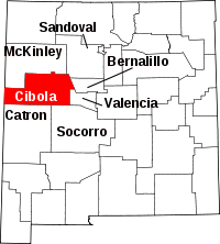 | |
| Village | ||
| CDPs | ||
| Unincorporated communities | ||
| Indian reservations |
| |
| Footnotes | ‡This populated place also has portions in an adjacent county or counties | |
This article is issued from Wikipedia - version of the 6/7/2015. The text is available under the Creative Commons Attribution/Share Alike but additional terms may apply for the media files.