San Po Kong

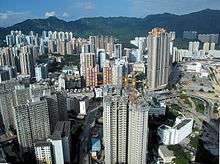
San Po Kong (Chinese: 新蒲崗; Cantonese Yale: San Po Gong) is an area in New Kowloon in Hong Kong. It is largely industrial and partly residential. Administratively, it belongs to Wong Tai Sin District.
Location
San Po Kong is located South of Wong Tai Sin and Diamond Hill, and north of the former Kai Tak International Airport. The area is bounded by Choi Hung Road and Prince Edward Road East.
History
Village
San Po Kong in Cantonese
Airport
In 1916, the area south of present-day San Po Kong was reclaimed by Ho Kai and Au Tak for a garden estate. The reclamation was completed in two phases in 1920 and 1927. The reclaimed area became known as Kai Tak. The company lacked the capital to complete the project and left part the land unused. The Hong Kong Government decided to buy back the land for the Royal Air Force and a future Kai Tak Aerodrome. In late 1930s, the airport was significantly expanded to take up the whole of San Po Kong. Clear Water Bay Road, part of the current Choi Hung Road, and a nullah were constructed around the airport. During the Japanese occupation of Hong Kong, more than 20 villages surrounding San Po Kong were demolished for further expansion of the airport.
Industrial area

In 1958, the airport was shifted south, out of San Po Kong and into Kowloon Bay. Prince Edward Road East was completed at around this time. San Po Kong became an industrial area, in many high-rise buildings. The government also established the San Po Kong Factory Estate, a factory estate for small manufacturing businesses in the early 1960s.[1]
In May 1967, a labour dispute in a factory making artificial flowers ignited the 1967 riots, which lasted until October. During that period, public bus services were suspended, forcing workers from other areas to commute on foot.
In the 1980s, many of the manufacturing businesses in San Po Kong relocated to China, and the industrial buildings were turned into offices and godowns.
Features
Facilities in San Po Kong include:
- Mikiki, a shopping mall
- Choi Hung Road Playground
- Rhythm Garden, a housing estate
- Ho Lap College
- Ng Wah Catholic Secondary School
Transport
San Po Kong is served by the Diamond Hill Station of the MTR.
See also
References
- ↑ Heritage Impact Assessment on Chai Wan Factory Estate, Hong Kong Housing Authority, April 2013. p.78
External links
| Wikimedia Commons has media related to San Po Kong. |
- Working Paper No. 33. Regeneration of Industrial Areas in Metro Area - A Hypothetical Case Study at San Po Kong, Planning Department, November 2003
Coordinates: 22°20′08″N 114°11′54″E / 22.33547°N 114.19837°E