San Luis, Agusan del Sur
| San Luis | |
|---|---|
| Municipality | |
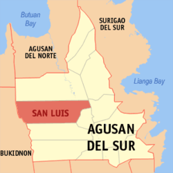 Location within Agusan del Sur province | |
.svg.png) San Luis Location within the Philippines | |
| Coordinates: 8°30′N 125°44′E / 8.5°N 125.74°ECoordinates: 8°30′N 125°44′E / 8.5°N 125.74°E | |
| Country | Philippines |
| Region | Caraga (Region XIII) |
| Province | Agusan del Sur |
| District | 1st district of Agusan del Sur |
| Barangays | 25 (see Barangays) |
| Government [1] | |
| • Type | Sangguniang Bayan |
| • Mayor | Ronaldo Y. Corvera |
| Area[2] | |
| • Total | 950.5 km2 (367.0 sq mi) |
| Population (2015 census)[3] | |
| • Total | 32,109 |
| • Density | 34/km2 (87/sq mi) |
| • Voter (2016)[4] | 16,701 |
| Time zone | PST (UTC+8) |
| ZIP code | 8511 |
| IDD : area code | +63 (0)85 |
| Income class | 1st class |
| PSGC | 160309000 |
San Luis, officially the Municipality of San Luis (Filipino: Bayan ng San Luis), is a municipality in the province of Agusan del Sur in the Caraga (Region XIII) of the Philippines. The population was 32,109 at the 2015 census.[3] In the 2016 election, it had 16,701 registered voters.[4]
San Luis was created into a municipality on June 15, 1968, when the barrios of San Luis, Santa Inez, Nuevo Trabajo, Cualision and Baylo were separated from the municipality of Esperanza and constituted into the new town, through Republic Act 5262.[5] Since the 1970s, the town's economy has been largely based on logging industries.[6]
Geography
San Luis is located at 8°30′N 125°44′E / 8.5°N 125.74°E.
According to the Philippine Statistics Authority, the municipality has a land area of 950.5 square kilometres (367.0 sq mi)[2] constituting 9.51% of the 9,989.52-square-kilometre- (3,856.98 sq mi) total area of Agusan del Sur.
Barangays
San Luis is politically subdivided into 25 barangays.[7]
| PSGC | Barangay | Population | ±% p.a. | ||
|---|---|---|---|---|---|
| 2015[3] | 2010[8] | ||||
| 160309001 | Anislagan | 6.2% | 1,998 | 1,947 | +0.49% |
| 160309008 | Balit | 2.7% | 868 | 1,139 | −5.04% |
| 160309002 | Baylo | 4.8% | 1,555 | 1,328 | +3.05% |
| 160309009 | Binicalan | 10.4% | 3,353 | 3,103 | +1.49% |
| 160309010 | Cecilia | 3.5% | 1,135 | 1,136 | −0.02% |
| 160309003 | Coalicion | 4.4% | 1,398 | 1,643 | −3.03% |
| 160309004 | Culi | 3.1% | 1,008 | 1,035 | −0.50% |
| 160309011 | Dimasalang | 4.3% | 1,387 | 1,360 | +0.38% |
| 160309012 | Don Alejandro | 8.1% | 2,600 | 2,648 | −0.35% |
| 160309013 | Don Pedro | 0.8% | 241 | 294 | −3.71% |
| 160309014 | Doña Flavia | 8.1% | 2,614 | 2,529 | +0.63% |
| 160309025 | Doña Maxima | 4.6% | 1,467 | 1,522 | −0.70% |
| 160309015 | Mahagsay | 3.1% | 1,009 | 1,242 | −3.88% |
| 160309016 | Mahapag | 2.3% | 730 | 695 | +0.94% |
| 160309017 | Mahayahay | 2.5% | 795 | 1,135 | −6.55% |
| 160309018 | Muritula | 2.3% | 743 | 769 | −0.65% |
| 160309005 | Nuevo Trabajo | 5.8% | 1,876 | 1,725 | +1.61% |
| 160309006 | Poblacion | 5.7% | 1,815 | 1,653 | +1.80% |
| 160309019 | Policarpo | 1.5% | 486 | 533 | −1.74% |
| 160309020 | San Isidro | 2.5% | 807 | 955 | −3.16% |
| 160309021 | San Pedro | 3.8% | 1,219 | 1,567 | −4.67% |
| 160309007 | Santa Ines | 5.4% | 1,748 | 1,453 | +3.58% |
| 160309022 | Santa Rita | 0.9% | 301 | 456 | −7.60% |
| 160309023 | Santiago | 1.6% | 499 | 465 | +1.35% |
| 160309024 | Wegguam | 1.4% | 457 | 401 | +2.52% |
| Total | 32,109 | 32,733 | −0.37% | ||
Demographics
| Population census of San Luis | |||||||||||||||||||||||||
|---|---|---|---|---|---|---|---|---|---|---|---|---|---|---|---|---|---|---|---|---|---|---|---|---|---|
|
| ||||||||||||||||||||||||
| Source: PSA[3][8][9] | |||||||||||||||||||||||||
In the 2015 census, San Luis had a population of 32,109.[3] The population density was 34 inhabitants per square kilometre (88/sq mi).
In the 2016 election, it had 16,701 registered voters.[4]
References
- ↑ "Municipality". Quezon City, Philippines: Department of the Interior and Local Government. Retrieved 31 May 2013.
- 1 2 "Province: Agusan del Sur". PSGC Interactive. Makati City, Philippines: Philippine Statistics Authority. Retrieved 28 October 2016.
- 1 2 3 4 5 "CARAGA". Census of Population (2015): Total Population by Province, City, Municipality and Barangay (Report). PSA. Retrieved 20 June 2016.
- 1 2 3 "2016 National and Local Elections Statistics". Commission on Elections. 2016.
- ↑ "Republic Act No. 5262; An Act Creating the Municipality of San Luis in the Province of Agusan". The Corpus Juris. 15 June 1968. Archived from the original on 18 October 2016. Retrieved 18 October 2016.
- ↑ Dumas, Louie G. (4 March 2011). "Logging ban forces locals to look for other jobs". BusinessWorld Online. BusinessWorld Publishing Corporation. Retrieved 18 October 2016.
- ↑ "Municipal: San Luis, Agusan del Sur". PSGC Interactive. Quezon City, Philippines: Philippine Statistics Authority. Retrieved 8 January 2016.
- 1 2 "CARAGA". Census of Population and Housing (2010): Total Population by Province, City, Municipality and Barangay (Report). NSO. Retrieved 29 June 2016.
- ↑ "CARAGA". Census of Population (1995, 2000 and 2007): Total Population by Province, City and Municipality (Report). NSO. Archived from the original on 11 November 2011.
External links
| Wikimedia Commons has media related to San Luis, Agusan del Sur. |
 |
Esperanza | | ||
| Impasugong, Bukidnon | |
San Francisco | ||
| ||||
| | ||||
| Malaybalay, Bukidnon | La Paz | Talacogon |
Prosperidad (capital) | |
| Municipalities | |
| Component city | |