San Benito Mountain
| San Benito Mountain | |
|---|---|
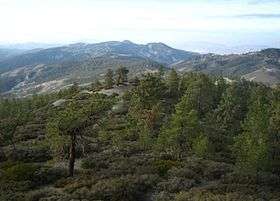 View from San Benito Mountain | |
| Highest point | |
| Elevation | 5,267 ft (1,605 m) NAVD 88[1] |
| Prominence | 3,481 ft (1,061 m) [2] |
| Listing | California county high points 38th |
| Coordinates | 36°22′10″N 120°38′41″W / 36.369579269°N 120.644657844°WCoordinates: 36°22′10″N 120°38′41″W / 36.369579269°N 120.644657844°W [1] |
| Geography | |
 San Benito Mountain
| |
| Location | San Benito County, California, U.S. |
| Parent range | Diablo Range |
| Topo map | USGS San Benito Mountain |
San Benito Mountain is a mountain located in the Diablo Range of California. The highest point is at an elevation of 5,267 feet (1,605 m). The rock is composed of asbestos (chrysotile), an ultramafic rock. It weathers to produce serpentine soils with characteristically low levels of nutrients like nitrogen, phosphorus, potassium, and calcium, and high levels of magnesium and heavy metals including nickel and chromium. This means little vegetation grows in the area though there are some plants that only grow on such soils like the local endemic San Benito evening primrose. Some of the highest peaks are clad in a unique pine and incense cedar forest.
There are two superfund sites in the area, both associated with the mining and processing of chrysotile asbestos. There are also mines producing gems and the minerals cinnabar, chromite, magnesite, and jadeite are also mined here. The Clear Creek Management Area which includes the San Benito Mountain Research Natural Area has been closed to visitors since 2008 because of the hazards to health of the asbestos. Prior to that it had been a popular site for the use of off-road vehicles.
Geology
The mountain, which rises to an elevation of 5,267 feet (1,605 m), is the highest point in San Benito County and the Diablo Range.[2] The mountain gets some snowfall during winter.[3] The rock is a chrysotile serpentine, a soft fibrous silicate material. Extreme shearing of the bedrock, combined with soil nutrient imbalances, has resulted in extensive areas of natural barrens completely devoid of vegetation. The serpentine soils harbor several rare plant species, including the Federally listed Threatened San Benito evening primrose (Camissonia benitensis). A unique pine and incense cedar forest occurs at the highest elevations of the mountain and in 1980, the San Benito Mountain Research Natural Area was designated an Instant Wilderness Study Area.[4]
The serpentine mass contains two superfund sites, Atlas Mine and Johns-Mansville. Both were associated with the mining and processing of chrysotile asbestos. Other minerals mined from the serpentine mass included cinnabar, chromite, magnesite, and jadeite. The Gem mine (private) located within the serpentine mass is the only source of gem-grade benitoite in the world. The rare minerals neptunite and joaquinite have also been found there.
Closure
The Clear Creek Management Area, which encompasses the San Benito Mountain Research Natural Area, has been subject to a temporary closure by the BLM since May 2008 due to concerns of visitor exposure to naturally occurring asbestos (chrysotile).[5] The area was a major OHV riding area prior to the closure. The core area of the Clear Creek Management Area (approximately 35,000 acres) is the New Idria serpentine mass. The serpentine is highly sheared/pulverized and contains abundant chrysotile asbestos.
References
- 1 2 "5258". NGS data sheet. U.S. National Geodetic Survey.
- 1 2 "San Benito Mountain, California". Peakbagger.com.
- ↑ "Subsection M262Ac - Diablo Range". U.S. Forest Service. Archived from the original on 2005-03-15. Retrieved 2014-02-22.
- ↑ "San Benito Mountain Research Natural Area". US Department of the Interior: Bureau of Land Management. Retrieved 12 January 2016.
- ↑ "Clear Creek Management Area". Bureau of Land Management. Retrieved 2009-12-22.