Samar (province)
| Samar | |||
|---|---|---|---|
| Province | |||
| Province of Samar | |||
| |||
| Nickname(s): The Caving Capital of the Philippines[1] | |||
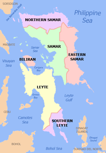
 Location in the Philippines | |||
| Coordinates: 11°50′N 125°00′E / 11.83°N 125°ECoordinates: 11°50′N 125°00′E / 11.83°N 125°E | |||
| Country | Philippines | ||
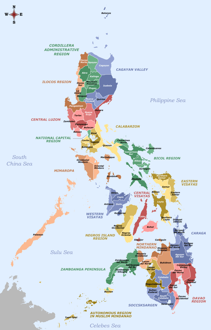
| Region | Eastern Visayas (Region VIII) | ||
| Founded | 1768 | ||
| Capital | Catbalogan | ||
| Government | |||
| • Type | Sangguniang Panlalawigan | ||
| • Governor | Sharee Ann T. Tan (NPC) | ||
| • Vice Governor | Stephen James T. Tan (NP) | ||
| • 2nd District Representative | Milagrosa T. Tan (NPC) | ||
| • 1st District Representative | Engr. Edgar S. Sarmiento (Liberal) | ||
| Area[2] | |||
| • Total | 6,048.03 km2 (2,335.16 sq mi) | ||
| Area rank | 10th out of 81 | ||
| Population (2015 census)[3] | |||
| • Total | 780,481 | ||
| • Rank | 37th out of 81 | ||
| • Density | 130/km2 (330/sq mi) | ||
| • Density rank | 64th out of 81 | ||
| Divisions | |||
| • Independent cities | 0 | ||
| • Component cities | |||
| • Municipalities | |||
| • Barangays | 951 | ||
| • Districts | 1st and 2nd districts of Samar | ||
| Time zone | PHT (UTC+8) | ||
| ZIP Code | 6700–6725 | ||
| IDD : area code | +63 (0)55 | ||
| ISO 3166 code | PH-WSA | ||
| Spoken languages | |||
| Website |
samar | ||


Samar (Waray-Waray: Probinsya han Samar, Filipino: Lalawigan ng Samar, Cebuano: Lalawigan sa Samar, formerly known as Western Samar) is a province in the Philippines located in the region of Eastern Visayas. Its capital is Catbalogan City.
The province covers the western section of Samar Island and several islands in the Samar Sea situated west of the mainland. It is bordered on the north by Northern Samar, east by Eastern Samar, south by Leyte and the Leyte Gulf, and west by the Samar Sea. Samar is connected to the island of Leyte via the San Juanico Bridge, which spans the San Juanico Strait, the narrowest strait in the world.
Samar, along with Leyte province, was created after the historical province of the same name was split into two independent provinces in 1768. Samar province occupied the entire island of Samar and its adjacent islands until 1965, when it was partitioned into three provinces (Northern Samar, Eastern Samar and "Western" Samar).
Fishing and agriculture are the major economic activities in the province.[4]
On 8 November 2013, the province was significantly damaged by Super Typhoon Yolanda (Haiyan), particularly at the towns of Basey and Marabut.
Etymology
Samar is said to be derived from Samad, the Visayan word for "wound" or "cut", describing the rough physical features of the land which is rugged and deeply dissected by streams.
History
- 1543 — The explorer Ruy López de Villalobos, first came to the island and named it Las Islas Filipinas.
- 1596 — Many names (such as Samal, Ibabao, Tandaya) were given to Samar Island prior to the coming of the Spaniards in 1596. The name "Samar" was derived from the local language samad, meaning "wound" or "cut", aptly describing the rough physical features of the island, rugged and deeply dissected by streams. During the early days of Spanish occupation, Samar was under the jurisdiction of Cebu.
- Arrival of the First Missionaries Jesuits — On October 15, 1596, the first Jesuit Mission arrived in Tinago (now Dapdap) in Tarangnan. From Tinago, the missionaries Fr. Francisco de Otazo, Bartolome Martes, and Domingo Alonzo began teaching Catechism healing the sick and spread the Christianity faith into the interior settlements.
- 1649 to 1650 — On June 1, 1649, the people of Palapag led by Agustin Sumuroy revolted against the decree of Governor General Diego Fajardo requiring able bodied men from the Visayas for service at the Cavite Shipyards. Like fire, the revolt quickly spread the neighboring town in the Northern and Western coast of Samar and to the nearby provinces of Bicol, Surigao, Cebu, Camiguin and as far as Zamboanga. It was suppressed in 1650 by the combined forces of the Spaniards, Lutaos, and Pampangos.
- 1735 — Samar and Leyte were united into one province with Carigara, in Leyte, as the capital town.
- 1768 — Samar again became a separate province in 1768.
- Royal Decree declares Samar as a Province — On August 11, 1841, Queen Isabella II of Spain signed a Royal Decree declaring Samar as a province.
- 1900 — The Battle of Catubig (April 15–18, 1900) occurred during the Philippine–American War. On April 15, 1900, the Filipino guerrillas launched a surprise attack on a detachment of US 43rd Infantry Regiment, forcing the Americans to abandon Catubig town after the four-day siege.
- 1901 — The Balangiga massacre occurred during the Philippine–American War. September 28, 1901, the people of Balangiga, Giporlos, Lawaan and Quinapondan in Eastern Samar surprised and attacked the American forces station there, killing 48 American soldiers. To avenge their defeat, American general Jacob H. Smith ordered his men to turn Samar into a "howling wilderness".
- 1941 — The invasion by the Japanese via fighter and bomber planes.
- 1941 to 1942 — Filipino troops of the 91st Infantry Division, Philippine Commonwealth Army, and USAFFE (under the Visayan-Mindanao Force) were established, but all fell to the invading Japanese forces. The general headquarters in Samar also fell to the Japanese. This resulted in the defeat of the Filipino troops of the USAFFE 91st Division.
- 1942 — The occupying Imperial Japanese forces arrived in the province of Samar.
- 1942 to 1944 — During the occupation, thousands of local Samareños — men and women — joined guerrilla groups in the province and helped local Filipino troops of the Philippine Commonwealth Army units fight the Japanese Imperial forces which led to the latter's defeat and started the pre-Allied liberation.
- The 4th, 9th, 93rd, 95th and 96th Infantry Divisions of the Philippine Commonwealth Army were re-established from 1942 to 1946 at the military general headquarters and military camps. The military unit organizations started the anti-Japanese military operations in the province from 1942 to 1945.
- The 96th Infantry Division of the Philippine Commonwealth Army was founded and established from 1942 to 1946 at the military general headquarters in the province of Samar.
- The Philippine Guerrilla Forces or PGF were established from 1942 to 1945 as a guerrilla resistance organization with headquarters in San Andres, Villareal, Samar.
- 1944 — The Battle off Samar took place on October 24 as Vice Admiral Takeo Kurita's Center Force warships clashed with several allied naval vessels in a collision course. His forces sank escort carrier USS Gambier Bay (CVE-73), destroyers USS Hoel (DD-533) and USS Johnston (DD-557), and escort destroyer USS Samuel B. Roberts (DE-413), but at a cost of his cruisers Chikuma, Chokai, and Suzuya. Despite being a tactical victory for the Imperial Japanese Navy, it did not alter the course of the Philippines campaign.
- 1944 to 1945 — Combined U.S. and Philippine Commonwealth military forces, including recognized guerrillas, liberated the province of Samar and defeated Imperial Japanese forces. The local Filipino soldiers, under the USAFFE 91st and the 4th, 9th, 93rd, 95th and 96th Infantry Divisions of the Philippine Commonwealth Army and 9th Infantry Regiment of the Philippine Constabulary, started the battles in Samar and fought against Japanese troops.
- 1945 — Filipino and Filipino-American soldiers under the 1st Filipino Infantry Regiment of the United States Army began the Battle of Samar and aided the local Filipino soldiers of the Philippine Commonwealth Army 4th, 9th, 91st, 93rd, 95th and 96th Infantry Divisions and the Philippine Constabulary 9th Infantry Regiment, the local Samareño guerrilla resistance and the U.S. liberation forces defeated the Japanese liberating the province of Samar.
- 1965 — On June 19, the Philippine Congress along with the three Samar Representatives, Eladio T. Balite (1st District), Fernando R. Veloso (2nd District) and Felipe J. Abrigo (3rd District), approved Republic Act No. 4221 dividing the region of Samar into three divisions: Northern Samar, Eastern Samar, and Western Samar. Each region adopted a new capital: Catbalogan (Western Samar), Borongan (Eastern Samar), and Catarman (Northern Samar).[5]
- 1969 — On June 21, under Republic Act No. 5650, Western Samar was renamed Samar with Catbalogan still as the capital.[6]
Geography
Samar province covers a total area of 6,048.03 square kilometres (2,335.16 sq mi)[7] occupying the central-western sections of the Samar island in the Eastern Visayas region. The province is bordered on the north by Northern Samar, east by Eastern Samar, south by Leyte and the Leyte Gulf, and west by the Samar Sea.
Topography
Samar province is hilly, with mountain peaks ranging from 200 to 800 metres (660 to 2,620 ft) high and narrow strips of lowlands, which tend to lie in coastal peripheries or in the alluvial plains and deltas accompanying large rivers. The largest lowlands are located along the northern coast extending up to the valleys of Catubig and Catarman rivers. Smaller lowlands in Samar are to be found in the Calbayog area and on the deltas and small valleys of Gandara and Ulot rivers. Slopes are generally steep and barren of trees due to deforestation. Run-off waters after heavy rains can provoke flooding in low-lying areas and the erosion of the mountains enlarges the coastal plains of the province.

Climate and rainfall
Areas near the eastern coast of the province have no dry season (with a pronounced maximum rain period usually occurring from December to January), and are thus open to the northeast monsoon. Municipalities in the southeastern section of the province experience this type of climate.
Areas located in the northwestern portion of the province have a more or less evenly distributed rainfall throughout the year.
Administrative divisions
The province of Samar comprises two congressional districts, 24 municipalities and two component cities. It has a total of 952 barangays.
- † Provincial capital and component city
- ∗ Component city
- Municipality
| |||||||||||||||||||||||||||||||||||||||||||||||||||||||||||||||||||||||||||||||||||||||||||||||||||||||||||||||||||||||||||||||||||||||||||||||||||||||||||||||||||||||||||||||||||||||||||||||||||||||||||||||||||||||||||||||||||||||||||||||||||||||||||||||||||||||||||||||||||||||||||||||||||||||||||||||||||||||||||||||||||||||||||||||||||||||||||||||||||||||||||||||||||||||||||||||
Demographics
| Population census of Samar | ||
|---|---|---|
| Year | Pop. | ±% p.a. |
| 1990 | 533,733 | — |
| 1995 | 589,373 | +1.88% |
| 2000 | 641,124 | +1.82% |
| 2007 | 695,149 | +1.12% |
| 2010 | 733,377 | +1.97% |
| 2015 | 780,478 | +1.19% |
| Source: Philippine Statistics Authority[3][8][8] | ||
The population of Samar (province) in the 2015 census was 780,481 people,[3] with a density of 130 inhabitants per square kilometre or 340 inhabitants per square mile.
Religion
Samar (Western Samar) is predominantly Roman Catholic. The Catholic Hierarchy (2014) states that 95 percent of its population adhere to Roman Catholicism. Some other Christian believers constitute most of the remainder such as Born-again Christians, Iglesia Ni Cristo, Baptists, Methodists, Jehovah's Witnesses, Church of Christ of Latter Day Saints and Seventh-day Adventist. Muslims are also present and a few mosques are located within the province.
Languages and dialects
Residents of Samar are mostly Waray, the sixth largest cultural-linguistic group in the country. 90.2 percent of the household population speaks the Waray-Waray language, while 9.8 percent also speak Cebuano; 8.1 percent Boholano; 0.07 percent Tagalog; and 0.5 percent other languages.
There are two types of Waray spoken in the province, Waray Lineyte-Samarnon which is spoken from the southernmost tip of the province up to the municipality of Gandara and Waray Calbayog, an intermediary between the Waray of Northern Samar and the Waray of Samar, spoken in Calbayog City, Santa Margarita, and in some parts of Tagapul-an, Santo Niño, Almagro and Matuguinao.
Cebuano is spoken in some parts of the first district of Samar, mainly in Calbayog City, Almagro, Santo Niño and Tagapul-an. English and Chinese languages are also spoken.
Former governors
Notable people
- Captain Luciano Sinko — Aide de Camp of General Lukban the first Representative of Samar to the First Philippine National Assembly. Who was born on January 7, 1873, son of Mr.and Mrs. Juan Sinko. He had two wives namely, his first wife was Petrona Tanseco and his 2nd wife was Victoria Sabater. Elected Municipal Councilor in 1907. Given posthumous Award for outstanding achievement in the field of government service during the First Samar Day Celebration.
- Senator Esteban Quimbo Singzon — born in Calbiga, Samar. Son of Doroteo B. Singzon and Mamerta A. Quimbo. First senator of the ten senatorial districts of Samar and Leyte, 1915. One of the first Philippine senators.
- Bishop Pablo Singzon — the first Bishop of Samar and Leyte. He was born on January 25, 1851 in Calbiga, Samar, son of Esteban Singzon and Demetria Baeza. He first studied his primary years in Calbiga, Samar his native town under the direction of the Franciscan Fathers Fr. Antonio Figueroa Fr. Antonio Sanchez and Fr. Andres Congzon, a secular priest. He studied his secondary years in San Carlos Seminary, Cebu and entered in the Pontifical and Royal University of Santo Tomas – The Eternal City of Rome for his seminary. He was awarded a Medal from Pope Leo III, Bishop of Rome and become the first bishop of Samar and Leyte in 1910.
- Pedro Rosell Arteche — the founder and leader of Philippine Guerilla forces of Samar. Born on April 21, 1900 in Barangay Kampondoy, Zumarraga, Samar. He was the son of late Nemesio Arteche and Pia Rosell. He was studied law. An active student leader and athlete, a man of principle, of firm conviction. and as a lawyer, he volunteered his service in deserving cases … of poor persons oppressed. While serving as Governor, he reminded the National Officials of the appointment of Samareños to top government positions and was successful.
- Bruna "Bunang" Fabrigar — known as the "Joan of Arc of Samar". One of the historic Pulahan leader in Samar. “Bunang”, as she was popularly called, was described as a kind and religious, a heroine, attractive, a mananambal (faith-healer), and a courageous leader. Bruna Fabrigar has a red “magic saya” that she used as her shield against bullets. She is from Paranas, Samar and she served as the people’s “mananambal”. She believes that faith in God could conquer the enemies.
Proposed creation of Samar Administrative Region (SamAR)
There is a propossed creation of Samar Administrative Region or SamAR, in which Eastern Visayas will be partitioned into two separate regions. Since the creation of Negros Island Region out of the regions of Western Visayas and Central Visayas, non-government organizations, local government units and people from the three Samar Island provinces are now expressing their support and willingness to put the provinces of Samar, Northern Samar and Eastern Samar into one separate administrative region in order to boost its economy, improve and directly provide to its people the government's basic and other public services and lower its poverty rate incidence, since Samar island's three provinces are listed as one of the poorest provinces of the Philippines.[10][11]
References
- ↑ Togonon, Mark Anthony (1 November 2015). "Enchanted". Manila Bulletin. Retrieved 23 March 2016.
... there are more than a thousand caves in the province alone, most of them still unexplored. “Samar isn’t called the Caving Capital of the Philippines for nothing,” he says.
- ↑ "List of Provinces". PSGC Interactive. Makati City, Philippines: National Statistical Coordination Board. Retrieved 12 April 2013.
- 1 2 3 4 "Region VIII (EASTERN VISAYAS)". Census of Population (2015): Total Population by Province, City, Municipality and Barangay (Report). PSA. Retrieved 20 June 2016.
- ↑ http://www.samar.lgu-ph.com/econo.htm Economical Data
- ↑ "Republic Act No. 4221 - An Act Creating the Provinces of Northern Samar, Eastern Samar and Western Samar". Chan Robles Virtual Law Library. 19 June 1965. Retrieved 18 April 2016.
- ↑ "Republic Act No. 5650 - An Act Changing the Name of the Province of Western Samar to Samar". Chan Robles Virtual Law Library. 21 June 1969. Retrieved 17 April 2016.
- 1 2 3 "Province: Samar (province)". PSGC Interactive. Quezon City, Philippines: Philippine Statistics Authority. Retrieved 8 January 2016.
- 1 2 3 "Region VIII (EASTERN VISAYAS)". Census of Population and Housing (2010): Total Population by Province, City, Municipality and Barangay (Report). NSO. Retrieved 29 June 2016.
- ↑ Table 5. Household Population by Ethnicity and Sex: Samar (Western), 2000
- ↑ "Samar Island might follow Negros Island into a new region". Edgar Allan Vilbar. Retrieved February 28, 2016.
- ↑ "Presidential candidate Grace Poe backs the creation of separate Samar Region". Xianne Arcangel. Retrieved March 10, 2016.
External links
-
 Samar travel guide from Wikivoyage
 -
 Media related to Samar (province) at Wikimedia Commons
 -
 Geographic data related to Samar (province) at OpenStreetMap
 - Samar News.com—based in Catbalogan, it is a source of news and information on Eastern Visayas.
- Province of Samar—Profile of the Samar province
- Local Governance Performance Management System
 |
Northern Samar | | ||
| Masbate Biliran / Samar Sea |
|
Eastern Samar | ||
| ||||
| | ||||
| Leyte / San Juanico Strait | Leyte Gulf |
Catbalogan (capital) | |
| Municipalities | |
| Component cities | |