Samaipata, Bolivia
| Samaipata Samaypata | |||
|---|---|---|---|
| Town | |||
|
Samaipata | |||
| |||
 Samaipata Location in Bolivia | |||
| Coordinates: BO 18°10′44″S 63°52′30″W / 18.17889°S 63.87500°W | |||
| Country | Bolivia | ||
| Department | Santa Cruz Department | ||
| Province | Florida Province | ||
| Municipality | Samaipata Municipality | ||
| Population (2012) | |||
| • Total | 4,398[1] | ||
| Time zone | BST (UTC-4) | ||
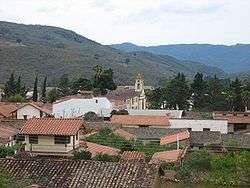

Samaipata or Samaypata[2] (Quechua samay to rest, pata elevated place / above, at the top / edge, bank (of a river), shore)[3][4] is a small location in the Florida Province of the Santa Cruz Department in Bolivia. With its delightful subtropical climate and an altitude of 1600–1800 m it tempts foreigners to settle. The little village is a kind of Micromundo where now about 25 nationalities live together in harmony and peace. It lies about 120 kilometers to the southwest of the city of Santa Cruz de la Sierra in the foothills of the Andes on the way to Sucre. It is a popular resort for inhabitants of Santa Cruz due to its much cooler climate. As such, there is regular bus and taxi service to Santa Cruz. The town is small with numerous colonial buildings and narrow cobbled streets. There is a good range of hotels and restaurants to suit all budgets. There are numerous tour agencies and guided tours operators. International as well as local tourism makes this into one of the few "boom" towns of the area. It is strategically located near several tourist attractions such as El Fuerte de Samaipata, the Amboro National Park, El Codo de los Andes, several waterfalls, vineyards, rapids and lagoons, as well as well-preserved colonial towns such as Vallegrande, Pampagrande, Postrervalle, Santiago del Valle, Pucara, and others. It is also the first stop in the several tourist trails to Sucre and Potosi, and the Che Guevara route.
History

The valley was originally populated by people of the Chane culture dedicated to agriculture, hunting and gathering. The Chanes are famous for their densely populated villages, their ceramics and graphic designs, and most importantly the construction of the temple at El Fuerte de Samaipata.[5] They cultivated mainly corn and peanuts, and were rather peaceful. There are several Chane burial sites all through the valleys and pampas of Santa Cruz between the Siberia mountain ridge and the Guapay river.
The region was later conquered by Incas as they expanded to the southeast from their native Peru. The Incas reached a pact with the Chanes and built a city at El Fuerte de Samaipata.
In the 16th century, Guarani warrior tribes, called Chiriguanos by the Incas and Spanish, coming from the south invaded the valley and defeated both Incas and Chanes. The Guaranis continued raiding the valley and the region until the 19th century.
In 1618, Pedro de Escalante y Mendoza founded Samaipata,[6] as point of contact between Santa Cruz and Vallegrande. The town moved from its original location in a place known as Castilla to its current location a few kilometers west.
People
Samaipata is quite cosmopolitan and diverse for being such a small town. Local Samaipateños from old families are descendants of Spanish colonists from Vallegrande and Santa Cruz (many of whom were of Sephardic origin) and the local Guarani natives that had invaded the valley prior to the arrival of the Spaniards. Beginning in the 1880s, some Arab families settled in Samaipata, they were follow by a few Croatians and Italians, all of which mixed and assimilated to the local population.
After the road that passes by the town was paved in the 1960s, many migrants from all over Bolivia (mainly from nearby Santa Cruz, but also Cochabamba and Sucre) settled in this charming little town. Since the 1970s, several Germans, Dutch, French, Argentines and a few Japanese also moved to Samaipata and made it their home.
Economy
The local economy is mainly dedicated to tourism, agriculture (including its many vineyards) and crafts. Local farmers produce organic vegetables such as tomatoes, artichokes, lettuces and green beans. The region is also famous for its production of fruits such as peaches, grapes, plums, chirimoyas, guapurus, strawberries, blackberries and figs. There is also a significant production of wines, singani, honey, marmalades, cold cuts,[7] herbal infusions, lavender, art pieces and artisan crafts.
%2C_Samaipata%2C_Bolivia.jpg)
Climate
Samaipata's climate is classified as Cfb by the Koppen climate classification system and Crbl by the Trewartha climate classification system. The climate is temperate, semi-dry in the winter months, and mild with an average annual temperature of 19.9 °C. During the winter months cold fronts called Surazos come from the Argentine Pampas and enter the plains and valleys of Santa Cruz, these cold winds combined with the altitude can reach temperatures below freezing. In the summer, the days are warm and the nights cool. Frost occurs on nine days in an average year, mostly in the winter months.[8]
| Climate data for Samaipata, Bolivia. 18 11 S, 63 53W. Elevation: 1,647 metres (5,404 ft) | |||||||||||||
|---|---|---|---|---|---|---|---|---|---|---|---|---|---|
| Month | Jan | Feb | Mar | Apr | May | Jun | Jul | Aug | Sep | Oct | Nov | Dec | Year |
| Daily mean °C (°F) | 21.7 (71.1) |
21.4 (70.5) |
21.2 (70.2) |
19.8 (67.6) |
18.3 (64.9) |
17.4 (63.3) |
16.7 (62.1) |
18.1 (64.6) |
19.8 (67.6) |
21.0 (69.8) |
21.5 (70.7) |
21.7 (71.1) |
19.9 (67.8) |
| Average precipitation mm (inches) | 121.3 (4.776) |
125.7 (4.949) |
95.3 (3.752) |
48.2 (1.898) |
27.3 (1.075) |
28.6 (1.126) |
13.5 (0.531) |
35.4 (1.394) |
32.5 (1.28) |
44.5 (1.752) |
78.8 (3.102) |
117.5 (4.626) |
768.6 (30.26) |
| Source: Weatherbase: Samaipata, Bolivia.[9] | |||||||||||||

Viniculture
Samaipata has a rooted wine culture that has endured since the first Spanish settlements in the Valleys of Santa Cruz and, although, it had a dwindling production during the Republican Era, in recent years, it has established itself as one of the most prominent wine regions in Bolivia. It is now the second wine region in terms of planted area and enjoys an increasing number of enotourists, particularly from Santa Cruz, Bolivia's largest city.
There are three established wineries in the region: Uvairenda (where the 1750 Wines are produced), Bodegas El Fuerte, and El Último Vargas. Located at 1.750 m.a.s.l., Uvairenda has arisen as its main representative for its high-quality wines and its success in the Bolivian market.
Known for its outstanding views and pleasant weather, Samaipata proves to be an idyllic place for vitiviniculture. Seasonal and day/night temperature variation together with protection from the cold winds from the South, provided by the hills that surrounds the numerous valleys, Samaipata and the rest of the Valleys of Santa Cruz have become an area of increased interest for its vinicultural potential.[10]
The main varieties produced are Tannat, Cabernet Sauvignon, Syrah, Torrontés, and Pedro Giménez, with the Tannat and Torrontés grapes becoming the emblematic grapes of the region. Other varieties cultivated, although in a lesser quantity, are Cabernet Franc, Malbec, Sauvignon Blanc and Riesling.[10]
Many of the vineyards of Samaipata are at a walking distance from the town center, and guided tours are provided by most of them, including wine tasting at the end of the tours.
Gallery
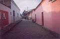 Streetscene. Traditional Spanish colonial houses face into a courtyard/garden for security reasons.
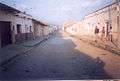 Streetscene. A neglected and unprepossessing exterior often hides a beautiful garden within.
El Fuerte de Samaipata
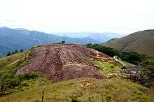
Nearby is the pre-Inca ruin of El Fuerte de Samaipata. It is not actually a fort, but a temple. This is Bolivia's largest pre-Inca site. Declared a world heritage sites by UNESCO in 1998,[11] this archaeological complex presents pre-Inca (Chane), Inca, and colonial Spanish ruins. The temple was originally built by Arawak people most likely belonging to the Chane[12] culture that inhabited the surrounding valleys and the pampas to the East. The temple was carved on an enormous rock. The Incas also built a city adjacent to the temple and established trade and alliances with the Chanes to protect the territories from the constant invasions of warrior Guarani tribes that raided the region from time to time. It is believed that both Chanes and Incas were eventually defeated by the Guarani warriors, and by the time the Spaniards colonized the region, it was already dominated by Guarani tribes, and El Fuerte was already destroyed. The Spanish colonizers also built a town next to the temple, but it was later abandoned when the inhabitants moved to base of the valley.[13] There are several interesting features including a sloping ramp, pronounced by flying saucer enthusiast Erich von Däniken in his book "Chariots of the Gods" to be a launch platform for spaceships. Some of the site is now cordoned off due to damage caused by visitors walking on the rock carvings.

Las Cuevas.
Also of interest nearby, Las Cuevas , a pleasant walk by streams and waterfalls. There a several pools and beaches where the locals swim and disport themselves. A small fee is charged for entrance. Camping is not allowed.

 Rock pools and waterfall where the locals swim.
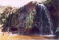 Landlocked Bolivia still has a beach-life!
 The park extends for several miles.
See also
References
- ↑ "censosbolivia.bo/comunitaria". Instituto Nacional de Estadística Bolivia (INE) 2012. Retrieved May 2, 2014.
- ↑ "Se inicia la celebración del 188 aniversario de la independencia de Bolivia". Vicepresidencia del Estado Plurinational, Presidencia de la Asamblea Legislativa Plurinational. Retrieved May 2, 2014.
- ↑ Teofilo Laime Ajacopa, Diccionario Bilingüe Iskay simipi yuyayk'ancha, La Paz, 2007 (Quechua-Spanish dictionary)
- ↑ Diccionario Quechua - Español - Quechua, Academía Mayor de la Lengua Quechua, Gobierno Regional Cusco, Cusco 2005 (Quechua-Spanish dictionary)
- ↑ Tras las Huellas de los Chané, June 1, 2003. "Archived copy". Archived from the original on 2008-12-06. Retrieved 2008-12-18.
- ↑ Belleza y Misterio de los Valles Cruceños, by Julio César Gamboa R. 2003
- ↑ "Samaipata, vendimia cruceña - La Razón". Retrieved 6 November 2016.
- ↑ "Samaipata, Bolivia, "Archived copy". Archived from the original on 2015-09-10. Retrieved 2016-11-05., accessed 5 Nov 2016
- ↑ accessed 5 Nov 2016
- 1 2 "Region overview | Wines of Bolivia". www.winesofbolivia.com. Retrieved 2015-12-23.
- ↑ Centre, UNESCO World Heritage. "Fuerte de Samaipata". Retrieved 6 November 2016.
- ↑ "Archived copy". Archived from the original on 2013-06-28. Retrieved 2008-12-18.
- ↑
Coordinates: 18°10′46″S 63°52′32″W / 18.17944°S 63.87556°W
External links
| Wikivoyage has a travel guide for Samaipata. |
| Wikimedia Commons has media related to Samaipata. |