Samad al-Shan
Coordinates: 22°48′40″N 58°9′0″E / 22.81111°N 58.15000°E
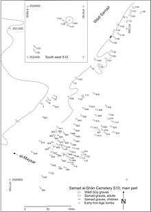
Samad al-Shan (22°48'N; 58°09'E) is an archaeological site in the Sharqiyah province, Oman where Late Iron Age remains were first identified, hence the Samad Period or assemblage.[1] The site was discovered by archaeological surveyors from Harvard University (1971). It is located 2 km east of the village of al-Maysar (since c. 1995 al-Moyassar). The excavation of this site (1981-1982) by Burkhard Vogt, Gerd Weisgerber and Paul Yule, (1987-1998) of the German Mining Museum, Bochum and later University of Heidelberg documented some 260 graves which span the Bronze Age to Late Iron Age in the Sultanate of Oman. Samad is the type-site for the non-writing Late Iron Age of Central Oman in south-eastern Arabia. This cultural assemblage evidences protoscript in the form of characters scratched onto pottery vessels. It is preceded by the Early Iron Age which differs in terms of pottery from that distributed in the neighbouring present-day United Arab Emirates. The remains of different pre-Islamic periods exist at Samad. Evidence appears from c. 100 BCE to c. 300 CE for the Samad Late Iron Age. Other artefact assemblages exist parallel to it in Oman and the United Arab Emirates. The Samad Late Iron Age is little researched, despite extensive excavation at the type-site. New research may easily change the chronology and area of distribution.
Sources
- Paul Yule, Die Gräberfelder in Samad al-Shan (Sultanat Oman): Materialien zu einer Kulturgeschichte (2001), ISBN 3-89646-634-8.
- Paul Yule, Late Pre-Islamic Oman: The Inner Evidence – The Outside View, Hoffmann-Ruf, M.–al-Salami, A. (eds.), Studies on Ibadism and Oman, Oman and Overseas, vol. 2, Hildesheim, 2013, 13–33, ISBN 978-3-487-14798-7
- Paul Yule, Cross-roads – Early and Late Iron Age South-eastern Arabia, Abhandlungen Deutsche Orient-Gesellschaft, vol. 30, Wiesbaden 2014, ISBN 978-3-447-10127-1
- Paul Yule, Valorising the Samad Late Iron Age, Arabian Archaeology and Epigraphy 27, 2016, 31-71, ISSN 0905-7196
References
- ↑ Paul Yule, Die Gräberfelder in Samad al-Shan (Sultanat Oman) Materialien zu einer Kulturgeschichte. Orient-Archäologie 4, Rahden 2001, ISBN 3-89646-634-8 ; Paul Yule, Cross-roads – Early and Late Iron Age South-eastern Arabia, Abhandlungen Deutsche Orient-Gesellschaft, vol. 30, Wiesbaden 2014, ISBN 978-3-447-10127-1, pages 62-66