Salmon Brook (Merrimack River)
| Salmon Brook | |
|---|---|
|
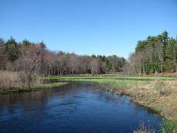
Salmon Brook in Dunstable, Massachusetts | |
| Country | US |
| Basin | |
| Main source |
Martins Pond 280 feet (85 m) at Groton, Massachusetts |
| River mouth | Merrimack River |
| Basin size | 36 square miles (93 km2) |
| Physical characteristics | |
| Length | 17.5 miles (28.2 km) |
| Discharge |
|
Salmon Brook is one of the 6 major tributaries of the Merrimack River in northeastern Massachusetts in the United States. Its watershed is 31 square miles (80 km2) and is one of the 14 subwatersheds of the Merrimack River. It passes through Groton, Dunstable, and Tyngsborough, Massachusetts, and then through Nashua, New Hampshire.
Route description
Salmon Brook begins at Martins Pond in Groton. It then flows approximately 17.5 miles (28.2 km) north-northeast to the Merrimack River. It runs through Lost Lake/Knops Pond, Whitney Pond, Cow Pond, and Upper and Lower Massapoag Ponds. All of these water bodies are dammed. The brook runs roughly parallel to the Nashua River from Lost Lake to the brook's mouth in Nashua.
See also
External links
Coordinates: 42°44′55″N 71°26′30″W / 42.74861°N 71.44167°W