Salinas River (California)
| Salinas River | |
| Rio del Monterey[1][2], Rio San Antonio[1], Rio San Elizario[3], Rio Santa Delfina[4] | |
| River | |
 View of the Salinas River near San Ardo during the "rainy-season." During the rainier winter months, the river may occasionally reconnect with Monterey Bay. The San Ardo Oil Field is visible in the distance. | |
| Country | United States |
|---|---|
| State | California |
| Tributaries | |
| - left | Nacimiento River, San Antonio River, Arroyo Seco |
| - right | Estrella River, San Lorenzo Creek |
| Cities | Paso Robles, Soledad, Salinas |
| Source | Los Machos Hills in the Los Padres National Forest |
| - location | San Luis Obispo County, California |
| - elevation | 2,150 ft (655 m) |
| - coordinates | 35°12′57.2394″N 120°13′26.112″W / 35.215899833°N 120.22392000°W [3] |
| Mouth | Monterey Bay |
| - location | 6 miles north of Marina, California |
| - elevation | 0 ft (0 m) |
| - coordinates | 36°44′58″N 121°48′13″W / 36.74944°N 121.80361°WCoordinates: 36°44′58″N 121°48′13″W / 36.74944°N 121.80361°W [3] |
| Length | 175 mi (282 km) [5] |
| Basin | 4,160 sq mi (10,774 km2) |
| Discharge | for near Spreckels |
| - average | 421 cu ft/s (12 m3/s) |
| - max | 95,000 cu ft/s (2,690 m3/s) |
| - min | 0 cu ft/s (0 m3/s) |
 Map of the Salinas River watershed | |
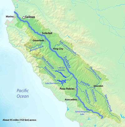
The Salinas River is the longest river of the central coast of California, running 175 miles (282 km) and draining 4,160 square miles.[6] It flows north-northwest and drains the Salinas Valley that slices through the central California Coast Ranges south of Monterey Bay.[3] The river begins in southern San Luis Obispo county originating in the Los Machos Hills of the Los Padres National Forest. From there, the river channel eventually makes its way to connect with the Pacific Ocean approximately 5 miles south of Moss Landing. The river is a wildlife corridor, and provides the principal source of water from its reservoirs and tributaries for the farms and vineyards of the valley.
History
The ancient geological history of the Salinas River is currently held by tectonic plate theory to most probably be rather unique amongst the many rivers of the North American Western Seaboard. The discovery of the great submarine canyon at the mouth of the Salinas River, the Monterey Canyon is the primary basis for this theory of what is now held to be the most probable ancient geological history for this river. [7]
The great length and depth of the submarine Monterey Canyon dwarf any other such canyons along the Pacific edge of the North American continent, and its dimensions are comparable in size to the submarine canyons that are currently found at the mouths of many much larger rivers, such as the Mississippi, the Ganges and the Nile. Still, the known flow-properties of the Salinas River in no way seem to indicate a river capable of creating such a large submarine outflow canyon. For this reason it is now theorized that at one point, probably many millions of years ago in the Miocene epoch, due to tectonic plate drift as currently calculated, the river was then probably located in the vicinity of what is now current day Los Angeles, and at that time may have served as the ancient mouth of the then Colorado River.[7]
During the more recent epoch of man's first appearance, known as the Pleistocene epoch, and on up until the age of the European discovery and exploration of Alta California, the Salinan indians and the Esselen indians lived along the Salinas river, and in the adjacent Salinas valley.
The Salinas river was first sighted by Europeans on September 27, 1769. This first European contact with the river was recorded by the Spanish "colonizing expedition" of Gaspar de Portolà. As was the practice of the Spanish government in the New World at the time, soldiers and priests were then typically sent out on such colonizing expeditions. Accordingly, the Portolà expedition included Franciscan priests, who soon thereafter established two missions along the banks of the Salinas river (then referred to as el Rio de Monterey.)
The new missions built along the banks of the Salinas river were the Mission Nuestra Señora de la Soledad established in 1791, and the Mission San Miguel Arcángel, established in 1797. The Mission San Antonio de Padua was also established during this same time period in the Salinas valley, but not on the river itself. These three missions were a part of the chain of 21 missions, then commissioned by the Spanish government in what is now the American State of California. All three of these missions remain to this day, the Soledad mission having evolved into the city of Soledad, and the San Miguel mission having evolved into the unincorporated village of San Miguel. The San Antonio mission is now surrounded by Fort Hunter Liggett land.
Due to the ever increasing, and as of yet unmonitored and unregulated heavy agricultural water demands along the Salinas valley, the river now typically remains dry and/ or without flow for the majority of the year.[8] Still the river has occasionally had notable flooding. Amongst these notable floods were the flood of 1964,[9] and the flood of 1995.[10]
Naming
During the Spanish/ Mexican period, the river was named "El Rio de Monterey." Soon after the American annexation of the area, it was renamed as the Salinas River. When first encountered by the Spanish Portola Expedition on September 27, 1769, the members of the expedition at first suspected that they had found the Carmel River, as discovered earlier by Vizcaino. One of the party members, Father Crespi, then proposed that the river might be a different river, and that it should therefore be given a new name, however he appears to have been over-ruled by the other members of his party at the time.
The first agreed upon name for the river, as it subsequently appeared on many Spanish and Mexican maps, was Rio de Monterey, presumably being named after the newly founded nearby town of Monterey. The earliest recorded use of this name for the river was a reference made by Fr. Pedro Font on March 4, 1776. This name continued in use as late as 1850.[1]
The river was apparently renamed as the "Salinas" river by an American cartogorapher in 1858, ten years after the 1848 American acquisition of California from Mexico. In 1858 the newer "Salinas" name first appeared on an American made map as the Rio Salinas, most probably so renamed after the nearby American founded town of Salinas, which in turn appears to have first been named in 1854 after the salty marshes of the Alisal Slough, over which the town of Salinas was first built.[11]
Description
The river begins in southern San Luis Obispo County, approximately 2.5 miles east of the summit point of Pine Ridge,[12] at a point just off of Agua Escondido Road, coming down off of the slopes of the Los Machos Hills of the Los Padres National Forest.[13][14] Its only dam forms the small Santa Margarita Lake. The Salinas flows down the valley bounded on its southwestern side by the Santa Lucia Mountain Range, and bounded on its northeastern side by the Gabilan Mountain Range. It flows past Atascadero and Paso Robles (to Monterey). It receives outflow from the Estrella River and the Nacimiento and San Antonio lakes through their river tributaries in southern Monterey County.
The river passes through the active San Ardo Oil Field, and then into and through the Salinas Valley. It flows past many small towns in the valley, including: King City, Greenfield, and Soledad, where it combines with the flash-flood prone Arroyo Seco.
It flows 3 miles south of the city of Salinas before cutting through Fort Ord and flows into central Monterey Bay approximately 3 miles west of Castroville. The final stretch of the river forms a lagoon protected by the 367 acre Salinas River National Wildlife Refuge and its outflow to Monterey Bay is blocked by sand dunes except during winter high-water flows.
- Historical course
The land owners altered the course of the river by filling in the river bed during the dry season. This allowed them to farm all of their land and use the water as they saw fit. The old stream bed went from the Old Salinas River, joining Elkhorn Slough on Monterey Bay near Moss Landing, to the present course where the main channel's mouth is directly on the Pacific Ocean. The Old Salinas River channel that diverts north behind the sand dunes along the ocean, is used as an overflow channel during the rainy season.
Hydrology
In 1769 when the river was first discovered by the Portola expedition, it was reported by them as being a "river watering a luxuriant plain" filled with fish weighing 8 or 10 pounds.[15] As of 2016, it has been transformed into little more than a dry bedded run-off feature for the majority of its length.
Nonetheless, with sufficiently heavy rains, and on rare occasions, this now normally dry runoff feature is still capable of quickly transforming itself back into a fast flowing river. In rainfall induced flood conditions, it can at times measure over a mile in width. During the 20th century, such flood conditions are reported to have generally occurred approximately once every 3 to 10 years. The last similar flooding event along the river was reported in 1998.[16]
The current typically dry state of the majority of the river may be more the result of human activity than of any recent changes in weather patterns. Rainfall patterns of recent years in the Salinas area have not significantly changed from historical average rainfall patterns (139 year average annual rainfall in Salinas is 13.26 inches per year, average annual rainfall since 2000 is 11.01 inches per year).[17][18] Recent increases in agricultural water use, individual consumer water use, and damming along the river may be contributing factors causing the now mostly dry condition of the riverbed.[19]
Ecology
The Arroyo Seco is the only major Salinas River tributary which remains un-dammed and supporting one of the most persistent remnants of the threatened Central Coast Steelhead trout (Oncorhynchus mykiss) that spawn in the Salinas River watershed. It is also an important middle link for salmon migrating from the Salinas River to Tassajara Creek and other tributaries.[20] A 2001 assessment of steelhead habitat of the Arroyo Seco and its Piney Creek tributary found high potential for steelhead population restoration.[21] Estrella River also remains un-dammed.
Other tributaries of the Salinas River that support steelhead include Paso Robles Creek, Jack Creek, Atascadero Creek, Santa Margarita Creek and Trout Creek in the upper reaches of the River. It can take over ten days for the steelhead from the upper part of the watershed to migrate to the Pacific Ocean near the City of Marina on Monterey Bay. From there, the steelhead migrate to the area west of the Aleutian Islands before returning to the spawning grounds in the tributaries of the Salinas River.[6]
Father Pedro Font described salmon in the Salinas River (Rio de Monterey) on the de Anza Expedition in March, 1776:"...there are obtained also many good salmon which enter the river to spawn. Since they are fond of fresh water they ascend the streams so far that I am assured that even at the mission of San Antonio some of the fish which ascend the Rio de Monterey have been caught. Of this fish we ate almost every day while we were here."[22] This meant that salmon would traverse the Salinas River and up the San Antonio River to end up near Mission San Antonio.
After depletion by 19th century fur trappers, California golden beaver (Castor canadensis subauratus) have expanded their range from the Salinas River mouth at least to its San Antonio River tributary below the reservoir.[23][24]
The upper Salinas River and its tributaries used to host large runs of steelhead trout and Chinook salmon. However the salmon were extirpated by 1915, largely by dams which prevented fish passage to spawning runs, and the steelhead are reduced to mere remnant populations.[6]
Agricultural use
The use of the river for irrigation in the Salinas Valley makes it one of the most productive agricultural regions in California. It is especially known as one of the principal regions for lettuce and artichokes in the United States. The river is shallow above ground, periodically dry, with much of its flow underground. The underground flow results from numerous aquifers, which are recharged by water from the Salinas, especially from the Nacimiento and San Antonio lakes during the dry months. In the 18th and early 19th centuries, the river valley provided the route of El Camino Real, the principal overland route from southern to northern Alta California, used by Spanish explorers and missionaries and early Mexican settlers.
See also
- Anne B. Fisher — "The Salinas, Upside Down River"
- List of rivers of California
References
- 1 2 3 Erwin G. Gudde, William Bright (2004). California Place Names: The Origin and Etymology of Current Geographical Names. University of California Press. p. 246. ISBN 978-0-520-24217-3. Retrieved 2010-12-15.
- ↑ Hoover, Mildred B.; et al. (1966). Historic Spots in California. 3rd edition. Stanford, California: Stanford University Press. p. 219.
- 1 2 3 4 U.S. Geological Survey Geographic Names Information System: Salinas River
- ↑ Bancroft, Hubert H. (1884–1890). History of California. 7 vols. San Francisco, California: A.L. Bancroft and Company. p. v1/p150. Retrieved 2010-12-15.
- ↑ Measured in Google Earth using the path measure tool
- 1 2 3 Donald J. Funk, Adriana Morales (2002–2003). Upper Salinas River and Tributaries Watershed Fisheries Report and Early Actions (PDF) (Report). Upper Salinas Tablas Resource Conservation District. Retrieved 15 December 2010.
- 1 2 The Impact of Tectonic Activity in the Development of Monterey Submarine Canyon Monterey Naval Postgraduate School. By Robert Allen Lloyd, Jr. 1982. Downloaded Nov. 26, 2016.
- ↑ Salinas Groundwater Sustainability Agency Plan Salinas Groundwater Sustainability Agency. March, 2016. Downloaded Dec. 4, 2016
- ↑ Looking Back: Salinas River, 1964 flooding Monterey Herald Newspaper, 10/23/2016, downloaded 10/28/2016.
- ↑ Officials try to figure out how to prevent Salinas River flooding before El Niño hits montereycountyweekly.com, Anna Ceballos, 10/1/2015, downloaded 10/28/2016
- ↑ David L. Durham (1998). California's geographic names: a gazetteer of historic and modern names of the state. Quill Driver Books. p. 1676. Retrieved 2010-12-15.
- ↑ Summit point of Pine Ridge Geohack. Downloaded 11-26-2016.
- ↑ USGS Topos 7.5 Minute, Los Machos Hills. CA
- ↑ Salinas River Source Point Geohack. Downloaded 11-26-2016.
- ↑ Three Parallel Portola Expedition 1769 diary accounts of Sept. 26, 1769. Pacifica History Project. Downloaded Nov. 20, 2016.
- ↑ Monterey County, Historical Flooding of the Salinas River Monterey County Archives, downloaded Nov. 15, 2016.
- ↑ 139 year Salinas precipitation annual average Western Regional Climate Center. Salinas weather- Period of Record : 02/01/1878 to 06/09/2016. Downloaded Nov. 20, 2016.
- ↑ US Weather Service annual precipitation records for Salinas As reported by Wunderground Weather. Downloaded Nov. 20, 2016
- ↑ Market Allocation of Agricultural Water Resources in the Salinas River Valley By John P. Neagley et. all. 1990. Downloaded Nov. 20, 2016.
- ↑ "Ventana Wild Rivers Campaign: Arroyo Seco River, Tassajara Creek & Church Creek". Ventana Wilderness Alliance's Wild Rivers Campaign. Retrieved 2010-12-15.
- ↑ Brian Londquist (2001-04-20). Steelhead (Oncorhynchus mykiss) Habitat Assessment Along the Arroyo Seco River, Undergraduate Thesis (PDF) (Thesis). California State University, Monterey Bay. p. 32. Retrieved 2010-12-15.
- ↑ Pedro Font. Expanded Diary of Pedro Font. Retrieved 2011-01-30.
- ↑ Barry Parr (2007). Explore! Big Sur Country A Guide to Exploring the Coastline, Byways, Mountains, Trails, and Lore. Globe Pequot. p. 174. ISBN 978-0-7627-3568-6. Retrieved 2010-12-16.
- ↑ "Salinas River National Wildlife Refuge". U.S. Fish and Wildlife Service. Retrieved 2010-12-16.
External links
| Wikimedia Commons has media related to Salinas River (California). |
- Upper Salinas-Las Tablas Resource Conservation District
- Reference Information for the Salinas River
- County Of Monterey - county homepage