Salga
| Salga | |
| Civil Parish | |
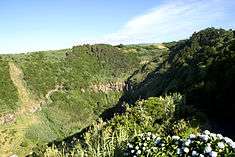 The lookout at Salto da Farinha, in the parish of Salga, showing the interior river-valley | |
| Official name: Freguesia da Salga | |
| Country | |
|---|---|
| Autonomous Region | |
| Island | São Miguel |
| Municipality | Nordeste |
| Center | Salga |
| - elevation | 220 m (722 ft) |
| - coordinates | 37°50′53″N 25°18′0″W / 37.84806°N 25.30000°WCoordinates: 37°50′53″N 25°18′0″W / 37.84806°N 25.30000°W |
| Highest point | Espigão dos Oveiras |
| - location | Planalto dos Gramihais |
| - elevation | 861 m (2,825 ft) |
| - coordinates | 37°47′39″N 25°16′8″W / 37.79417°N 25.26889°W |
| Area | 7.71 km2 (3 sq mi) |
| - urban | .18 km2 (0 sq mi) |
| Population | 488 (2011) |
| Density | 63/km2 (163/sq mi) |
| LAU | Junta Freguesia |
| - location | Rua Direita |
| - elevation | 215 m (705 ft) |
| - coordinates | 37°50′56″N 25°18′2″W / 37.84889°N 25.30056°W |
| Timezone | Azores (UTC-1) |
| - summer (DST) | Azores (UTC0) |
| Postal Zone | 9630-282 |
| Area Code & Prefix | (+351) 292 XXX-XXXX |
| Wikimedia Commons: Salga | |
| Geographic detail from CAOP (2010)[1] produced by Instituto Geográfico Português (IGP) | |
Salga is a civil parish in the municipality of Nordeste in Portuguese archipelago of the Azores. The population in 2011 was 488,[2] in an area of 7.71 km².[3]
History

Salga's settlement occurred late in the population of the island of São Miguel and the chronologist Gaspar Frutuoso referred to this territory as a land of natural pastures, used for hunting and wild "mountain pigs". It is from this that its name was given.
A little before 1746, a hermitage dedicated to Saint Joseph was first erected. At this time there were about 43 homes.
Then, on 3 October 1903, the cornerstone was set on a new church, constructed in front of the old hermitage, on the site of the Casa da Misericórdia. Its construction was ended in 1908.
The parish is one of the youngest of the municipality of Nordeste; a part of Achadinha since 1855, it became an administratively independent civil parish in 1980, but at the same time integrated into municipality of Nordeste.
Geography
Salga is located 1 kilometre (0.62 mi) east from the community of Achadinha and west of the seat of Nordeste. The construction and opening of the road of Salto de Cavalo allowed the convergence of traffic from north and south, in addition from north to northeast.
Economy
Owing to its history as a pastureland, the territory maintains a rural agricultural economy.
References
- ↑ IGP, ed. (2010), Carta Administrativa Oficial de Portugal (in Portuguese), Lisbon, Portugal: Instituto Geográfico Português, retrieved 1 July 2011
- ↑ Instituto Nacional de Estatística
- ↑ Eurostat