Salem, Iowa
| Salem, Iowa | |
|---|---|
| City | |
|
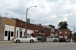
Downtown Salem, Iowa | |
 Location of Salem, Iowa | |
| Coordinates: 40°51′11″N 91°37′15″W / 40.85306°N 91.62083°WCoordinates: 40°51′11″N 91°37′15″W / 40.85306°N 91.62083°W | |
| Country |
|
| State |
|
| County | Henry |
| Area[1] | |
| • Total | 0.61 sq mi (1.58 km2) |
| • Land | 0.61 sq mi (1.58 km2) |
| • Water | 0 sq mi (0 km2) |
| Elevation | 715 ft (218 m) |
| Population (2010)[2] | |
| • Total | 383 |
| • Estimate (2012[3]) | 382 |
| • Density | 627.9/sq mi (242.4/km2) |
| Time zone | Central (CST) (UTC-6) |
| • Summer (DST) | CDT (UTC-5) |
| ZIP code | 52649 |
| Area code(s) | 319 |
| FIPS code | 19-70230 |
| GNIS feature ID | 0461353 |
Salem is a city in Henry County, Iowa, United States. The population was 383 at the 2010 census.
History
Salem was settled originally by Quakers with the intent that it be a community of Friends. In 1835 Aaron Street, while wending his way westward, came upon an uninhabited spot and declared “Now have mine eyes beheld a country teeming with every good thing…Hither will I come with my flocks and my herds, with my children and my children’s children, and our city shall be called Salem, for thus was the city of our fathers, even near unto the seacoast.”[4] Independently another Quaker, Isaac Pigeon, who may have visited the spot before Street, brought his family to the area. They became the first citizens of Salem, and with Peter Boyer, began to recruit other Quakers to migrate westward to join them. As early as 1837, Friends meetings were held in private homes, and after the village was laid out in 1839 by Aaron Street, Jr., and Peter Boyer, a meeting house was built.[5] From the early years members of other Christian denominations settled in Salem, so it was never an exclusively Quaker community.
Being only twenty miles from the Missouri border, Salem became an important depot on the Underground Railroad. A prominent member of the abolitionists was Henderson Lewelling. His house on West Main St. is listed on the National Register of Historic Places as an Underground Railroad station. The Friends, however, had a dispute over the issue of abolition. Agreed in their opposition to slavery, they disagreed on actively helping slaves escape. In 1846, 50 members of the community, including Lewelling, were disfellowshiped. In 1847, the Lewelling family traveled by covered wagon along the Oregon Trail along with a special covered wagon that had been designed to transport more than 700 young fruit and nut trees, apples, pears, peaches, cherries, quince, walnut, and hickory.[6] The surviving trees become the parent stock of all of the early orchards in the Pacific Northwest.
The Society of Friends also established a college in Salem. Whittier College, unrelated to the college of the same name in California, existed from 1868 to 1910.[7]
Geography
Salem is located at 40°51′11″N 91°37′15″W / 40.85306°N 91.62083°W (40.853073, -91.620845).[8]
According to the United States Census Bureau, the city has a total area of 0.61 square miles (1.58 km2), all of it land.[1]
Demographics
| Historical populations | ||
|---|---|---|
| Year | Pop. | ±% |
| 1880 | 524 | — |
| 1890 | 551 | +5.2% |
| 1900 | 548 | −0.5% |
| 1910 | 501 | −8.6% |
| 1920 | 494 | −1.4% |
| 1930 | 460 | −6.9% |
| 1940 | 457 | −0.7% |
| 1950 | 473 | +3.5% |
| 1960 | 442 | −6.6% |
| 1970 | 458 | +3.6% |
| 1980 | 463 | +1.1% |
| 1990 | 453 | −2.2% |
| 2000 | 464 | +2.4% |
| 2010 | 383 | −17.5% |
| 2014 | 378 | −1.3% |
| 2015 | 376 | −0.5% |
| Source:"American FactFinder". United States Census Bureau. and Iowa Data Center Source: | ||
2010 census
As of the census[2] of 2010, there were 383 people, 176 households, and 105 families residing in the city. The population density was 627.9 inhabitants per square mile (242.4/km2). There were 196 housing units at an average density of 321.3 per square mile (124.1/km2). The racial makeup of the city was 97.1% White, 0.5% African American, 0.3% Native American, 0.8% Asian, and 1.3% from two or more races. Hispanic or Latino of any race were 2.6% of the population.
There were 176 households of which 23.9% had children under the age of 18 living with them, 40.9% were married couples living together, 13.6% had a female householder with no husband present, 5.1% had a male householder with no wife present, and 40.3% were non-families. 34.1% of all households were made up of individuals and 14.2% had someone living alone who was 65 years of age or older. The average household size was 2.18 and the average family size was 2.80.
The median age in the city was 44.6 years. 21.4% of residents were under the age of 18; 7.3% were between the ages of 18 and 24; 22.5% were from 25 to 44; 29.7% were from 45 to 64; and 19.1% were 65 years of age or older. The gender makeup of the city was 44.1% male and 55.9% female.
2000 census
As of the census[10] of 2000, there were 464 people, 202 households, and 124 families residing in the city. The population density was 763.7 people per square mile (293.7/km²). There were 213 housing units at an average density of 350.6 per square mile (134.8/km²). The racial makeup of the city was 97.41% White, 0.22% Native American, 0.43% Asian, 0.22% from other races, and 1.72% from two or more races. Hispanic or Latino of any race were 0.65% of the population.
There were 202 households out of which 29.7% had children under the age of 18 living with them, 48.5% were married couples living together, 7.4% had a female householder with no husband present, and 38.6% were non-families. 33.7% of all households were made up of individuals and 20.3% had someone living alone who was 65 years of age or older. The average household size was 2.30 and the average family size was 2.98.
In the city the population was spread out with 23.7% under the age of 18, 5.8% from 18 to 24, 27.6% from 25 to 44, 23.3% from 45 to 64, and 19.6% who were 65 years of age or older. The median age was 40 years. For every 100 females there were 91.7 males. For every 100 females age 18 and over, there were 97.8 males.
The median income for a household in the city was $31,500, and the median income for a family was $42,500. Males had a median income of $30,238 versus $22,143 for females. The per capita income for the city was $18,585. About 3.7% of families and 3.2% of the population were below the poverty line, including 4.6% of those under age 18 and 3.1% of those age 65 or over.
Notable people
- Grenville Beardsley, Illinois Attorney General, was born in Salem.[11]
- Lorenzo D. Lewelling, Governor of Kansas; born in Salem.[12]
- Thomas Poulter, Antarctic explorer and Geophyics scientist.
See also
- Holtkamp Round Barn, listed on the National Register of Historic Places
References
- 1 2 "US Gazetteer files 2010". United States Census Bureau. Retrieved 2012-05-11.
- 1 2 "American FactFinder". United States Census Bureau. Retrieved 2012-05-11.
- ↑ "Population Estimates". United States Census Bureau. Retrieved 2013-05-23.
- ↑ The Quakers of Iowa. Clio Press. 1914. p. 40.
- ↑ The History of Henry County, Iowa: Containing a History of the County, Its Cities, Towns, &c. Western Historical Company. 1879. p. 536.
- ↑ History of Fruit Growing in the Pacific Northwest, Henderson Luelling and Seth Lewelling | url=http://www.ars-grin.gov/cor/cool/luelling.html
- ↑ The Quakers of Iowa. Clio Press. 1914. p. 242.
- ↑ "US Gazetteer files: 2010, 2000, and 1990". United States Census Bureau. 2011-02-12. Retrieved 2011-04-23.
- ↑ "Census of Population and Housing". Census.gov. Retrieved June 4, 2015.
- ↑ "American FactFinder". United States Census Bureau. Retrieved 2008-01-31.
- ↑ 'Illinois Blue Book 1959-1960,' Biographical Sketch of Grenville Beardsley, pg. 98
- ↑ "Kansas Governor Lorenzo Dow Lewelling". National Governors Association. Retrieved September 29, 2012.
Municipalities and communities of Henry County, Iowa, United States | ||
|---|---|---|
| Cities | ||
| Unincorporated community | ||
| Footnotes | ‡This populated place also has portions in an adjacent county or counties | |