Sakib
Coordinates: 32°17′7.61″N 35°48′40.59″E / 32.2854472°N 35.8112750°E
| Sakib ساكب | |
|---|---|
| Town | |
|
General view | |
 Sakib | |
| Coordinates: 32°17′7.61″N 35°48′40.59″E / 32.2854472°N 35.8112750°E | |
| Country |
|
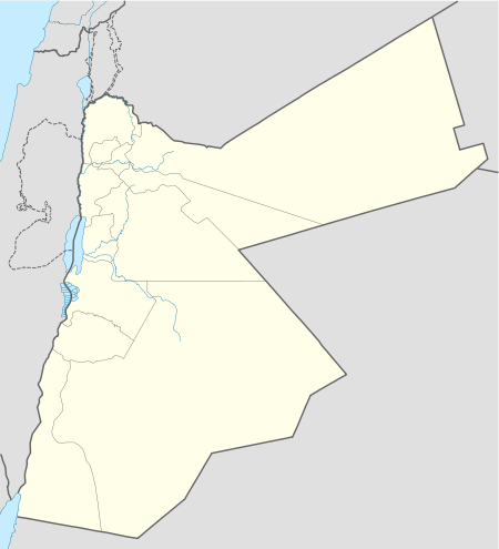
| Governorate | Jerash Governorate |
| Area | |
| • Town | 3 km2 (1 sq mi) |
| • Land | 21 km2 (8 sq mi) |
| Elevation | 900-1,250 m (4,101 ft) |
| Population (2004 estimate)[1] | |
| • Urban |
10,233 |
| 17,000 in 2012 | |
| Time zone | GMT +2 |
| • Summer (DST) | +3 (UTC) |
| Area code(s) | +962(2) |
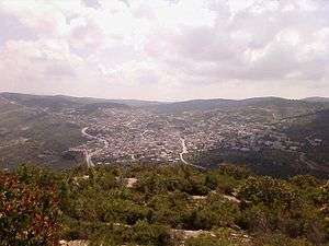
Sakib (![]() i/ˈsɑːkb/ SA-ki-b; Arabic: ساكب), is a Jordanian town in the northern corner of the country, a distance of 11 kilometers (7 mi) to the west of the city of Jerash, and 55 kilometers (34 mi) to the north of Jordan's capital city of Amman. Sakib is located on the highway which connects Jerash and Ajloun. It is close to several mountains overlooking Amman and most of the province of Jerash.
i/ˈsɑːkb/ SA-ki-b; Arabic: ساكب), is a Jordanian town in the northern corner of the country, a distance of 11 kilometers (7 mi) to the west of the city of Jerash, and 55 kilometers (34 mi) to the north of Jordan's capital city of Amman. Sakib is located on the highway which connects Jerash and Ajloun. It is close to several mountains overlooking Amman and most of the province of Jerash.
Sakib is inhabited by a Jordanian tribe called the Ayasrah, who have lived in Jordan for approximately five centuries.[2] Ayasrah took the name of the old village Aysra, which formed the northern part of the old Sakib.[3] Their lineage is traced back to the Quraysh originating from the Arabian Peninsula, and they are among the Hashemite descendants of the Prophet Muhammad.[4]
Sakib nowadays included three villages during the sixteenth century; Sakib village, Aysra village and Be'na (Beqia Al-Foqa) village.[5][6]
The importance of Sakib became apparent when the name of Jerash was abandoned, and Sakib came to mean both Jerash and Sakib. This was not, however, a permanent development, as the name "Jerash" reappeared in Ottoman tax registers by the 16th century.[6][7][8]
History
Etymology
Sakib's name is relative to the Scope of the water, where rain comes from the high mountains to the valleys. Alternatively, the town of Sakib took its name from "Seecip" because it was known as "Seecip" from the middle to late Islamic period.[6][5]
Byzantine period
During the Byzantine Empire (Eastern Roman Empire), the town was home to a Roman mint, and was also a major center for the pressing of olives. This is evidenced by the large number of old Roman olive presses and by a large Byzantine cemetery.[6][9][10] [11]
Early Muslim period
Umayyad Empire
The town was populated around the time of the Umayyad state in an area called Umm Jozeh (south-west of Sakib), as evidenced by the remnants of mosques present in the area.[6][12]
Ottoman period
Sakib was known as "Seecip" from the middle to late Islamic period.[13]

As mentioned in Ottoman documents, Sakib, as well as the settlements of Aysra and Be'na, joined the "Naheyat Ajloun" region of "Liwa Ajloun" in 1538,[14] and later the "Naheyat Bani Alwan" region of "Liwa Ajloun" in 1596.[15][2][16] Later, the town belonged to an area called "Alme'rad". The region was named "Alme'rad" ("resistance") due to its resistance against looting attacks by the Bedouin tribes. The local inhabitants led a resistance movement, which succeeded in defeating the Bedouin. Another reason for the name was the fact that the locals resisted the oppression of Ottoman rule.[6]
In the 16th century, the total population of the three villages was 33 households, including three Imams.[17][18] The townspeople were required to pay a tax on both livestock and crops, as well as Waqf (charity due to Muhyiddin Ibn Sharaf al-Din Kharroub), all collected for the army. The total value of these taxes in 1538 for the three villages was 3,800 Akçe (silver coins). This rose to 5,100 Akçe in 1596.[6]
Ma'an State - Prince Fakhr-al-Din II
Sakib witnessed important military campaigns, including the campaign of Prince Ali Fakhr-al-Din II in 1612, when he led a military campaign on the orders of his father to pursue Farroukh Sandzak Ajloun to Karak and Nablus. Prince Ali was able to defeat him, after which he set up camp in Sakib and remained there. However, the Levant ruler Hafiz Pasha wrote to the minister Nassouh Pasha that Fakhr al-Din had besieged Damascus. Nassouh Pasha then set out on a major campaign to defeat Fakhr al-Din, who called on the help of his son, Prince Ali.[6][19]
Modern Jerash
Inhabitants of Sakib and other ancient villages in Jerash region were among the founders of the modern city of Jerash in the early nineteenth century. Following the discovery of Jerash by German Orientalist Ulrich Jasper Seetzen in 1806,[20] efforts were made to begin excavations. After the Russo-Turkish War of 1877–78, a community of Circassians from the Caucasus Mountains were resettled by the Ottoman authorities in Transjordan and they majorly contributed in building the city. In addition, a large community of Syrians followed at the beginning of the twentieth century. The growth of Jerash encourged the inhabitants of villages to settle in the city.[6]
Saving Christian refugees
The Ayasrah family has made one of the most important steps that show the religious consciousness when the family received Christian refugees from all over the Levant and provided protection to Christians in Transjordan. This triggered the sedition which began in 1860 and continued for many years. Prince Abdelkader El-Djazairi is personally credited with saving large numbers of Christians by offering them shelter. The Ayasrah family attitude was to continue the work of Prince Abdelkader.[6]
The Ayasrah tribe declared at that if any form of abuse or assault occur to any Christian, it would be considered an attack on the tribe itself.
Rev. Klein, who visited Sakib in 1868, noted that some Greek Orthodox Christian families lived in Sakib side-by-side with Muslims, and stated that those Christian families produced tools needed by the farmers in exchange for a certain amount of grain. In 1869 the journal Church Missionary Intelligencer made a mention of Sakib, describing it as a beautiful, densely populated town, but lamenting the fact that there was a single Greek priest to look after the spiritual affairs of Christians in an area of 17 towns including Sakib.[6][21][22][23]
Defeating Jewish settlements in Transjordan
Jewish settlements in Transjordan were not as fortunate. Sakib witnessed important meetings which intended to eliminate the idea of establishing Jewish settlements on east of River Jordan, on the banks of the Zarqa River (Jabbok) in late 19th century. The tribes of Jordan held a war council in Sheikh Raja "ِAbu Shibley" Circuit in Sakib, and came to a decision to attack Jewish settlements on the Zarqa River, which they were able to eliminate. There is ongoing research on this historical aspect, with details not previously known yet to be published.[6]
Jerash Local Government
Jerash Local Government was one of seven local governments established in Transjordan after the fall of the Arab government in Damascus following the Battle of Maysaloun(Irbid, along with those of Ajloun, Salt, Jerash, Karak, Al Taibah, and Deir Yousef. It was established by the Jerash, Alme'rad and Bani Hassan tribal leaders in 1920, in order to fill the political vacuum, and played an important role in maintaining security and managing the needs of the population.
Although the government proved to be short-lived, it actually formed twice: first time it was headed by the mayor of the judiciary in the Covenant Faisaly, Muhammad Ali Al-Mughrabi, and it included Sheikh Shibley Raja Al-Ayasrah (a representative of Sakib), as well as representatives of Jerash and Alme'rad villages, as well as the tribe of the Bani Hassan. Upon the arrival of the English officer Reginald Monckton (1896-1975), following the formation of the British Mandate, there occurred a withdrawal of most of its members because of infighting. The second time the government formed, it was headed by Muhammad Ali Al-Mughrabi, and lasted another short period, until the establishment of the Emirate of Transjordan.[24][25]
Martyrs
Al-Ayasrah tribe in Sakib provided a large number of martyrs during the resistance against the British Mandate and the Israeli occupation of Palestine.[6]
Travellers and explorers
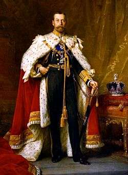
King George V
.jpg)
Sakib was the focus of attention of England in the late nineteenth century. George, Prince of Wales (later King George V of England), and his brother Prince Albert Victor, Duke of Clarence and Avondale, visited Sakib in 1882 during their visit to the Levant aboard Her Majesty's Ship "Bacchante", bound for the East. The two princes at that time took notes about Sakib, in which they said: "... We passed Sakib village at 9.10, and entered the Wady Hamftr (roebuck) at 9.30; long stretches of com were growing at the bottom, and the cliffs were wooded at the side with pines and oaks intermixed. A most enjoyable English-like morning as we ride along by the stream which goes gurgling over its pebble bed down the valley ; we cross it ever and anon, and dip in and out of the copses which clung to the hill-side and remind some of us much of Wales, and others of Scotland ..."[6][26]
The town was an important station on a trade road, with inhabitants trading with towns and cities in the west (Palestine). Saying were there a bridge over the Jordan (river) the traffic from the east to the west side of Jordan would probably show significant increase as former days.[Utterly nonsensical sentence; please review] Already Acre and Haifa export corn at the rate of 200 cargoes a day, all September and October, and the only difficulty connected with the trans-Jordanic corn is its transit from these fields to the coast. Then the Princes mentioned a wide range kinds of trees, flowers, birds and animals, repeated they can scarcely believe themselves in Syria, everything looks so much like in England.[6]
Claude Reignier Conder

Interestingly, the British soldier and explorer Claude Reignier Conder also visited the town between 1881-1882, and described it in a very romantic way giving significant details. He said: "... And by Sakib, on its cliff down which a stream falls in a long cascade, we gain the beautiful glens which run down from the rugged Ajlun to the green valley of Jordan. With exception of the woods of Tabor (now sadly thinned), the copses of Carmel, the oaks of Harosheth, and the groves of Banias, there is nothing in western Palestine which can at all compare with the beauty of the ravines of Gilead between Wady Hesban on the south and the Hairomax on the north. Beside clear mountain brooks the horseman wanders through glades of oak and terebinth, with dark pines above. The valleys green with corn, the streams fringed with oleander, the magnificent screens of yellow, green, and russet foliage, which cover the steep slopes, present a scene of quiet beauty, of chequered light and shade, of un-Eastern aspect which makes of Mount Gilead a veritable Land of Promise..."[6][27]
He also mentions many kinds of animals, birds, trees and herbs, and tells that the region still remained a prey to the wandering Arab and the Turk. The Romans built cities, and made roads marked yet by milestones in these rugged ranges ; but with the fall of Italian power the country has reverted to the primeval nomad, who seems destined to outlive each conquering race which for a time makes Syria its own. Without a peaceful population like that of a Jewish colony would find but little opportunity for the development of the national industrious and trading spirit. The colonies would be exposed to constant apprehension of Arab attacks, and would live a life like that of the priestly Hyrcanus.[6]
Rev. Klein
According to Rev. Klein, who visited Sakib in 1868, noted that some Greek Orthodox Christian families lived in Sakib side-by-side with Muslims, and stated that those Christian families produced tools needed by the farmers in exchange for a certain amount of grain. In 1869 the journal Church Missionary Intelligencer made a mention of Sakib, describing it as a beautiful, densely populated town, but lamenting the fact that there was a single Greek priest to look after the spiritual affairs of Christians in an area of 17 towns including Sakib.[6][21][22][28]
- Sakib Also was mentioned in the Atlas of the historical geography of the Holy Land.[29]
Geography
Location
 |
Ajlun | Ebien | Souf | |
| Anjara | |
Raymon, Jerash | ||
| ||||
| | ||||
| Kufranjah, Rajib | Burma, Zarqa River | Debien |
Topographic
| [30] | |||||||||||||
| City | Distance km (mi) | Site | |||||||||||
|---|---|---|---|---|---|---|---|---|---|---|---|---|---|
| Jerash | 11 (7) | East | |||||||||||
| Irbid | 45 (28) | North | |||||||||||
| Zarqa | 52 (32) | Southeast | |||||||||||
| Amman | 55 (34) | South | |||||||||||
| Beirut | 200 (124) | North | |||||||||||
| Damascus | 152 (94) | Northeast | |||||||||||
| Jerusalem | 79 (49) | Southwest | |||||||||||
Sakib's elevation is 900m to 1243m above sea level, and the area with farms and forests is about 24 km². Land and forests constitute 90% of this area. The city is located in the mountains and on an area about 3 km². The distribution of land above the cliffs of limestone ranging in intensity. Built along the highest mountains in north of Jordan which are: [31] [32]
| Site in City | Height m (ft) |
|---|---|
| Al-Qa`da Mountain | 1243 (4079) |
| Maqta Al-Qurmeya Mountain | 1197.8 (3930) |
| Troun Mountain | 1127.7 (3670) |
| Al-Adraj Mountain | 1110 (3642) |
| Al-Aqra` Mountain | 1092 (3583) |
Climate
Generally dominated by the climate of the Mediterranean basin, Sakib has cold winters and mild summers. The average rainfall is about 422 mm (16.6 inches) per year. The minimum temperature is about 12.25 °C (54.05 °F) and the highest temperature about 23.5 °C (74.3 °F) .[33]
| Climate data for Sakib | |||||||||||||
|---|---|---|---|---|---|---|---|---|---|---|---|---|---|
| Month | Jan | Feb | Mar | Apr | May | Jun | Jul | Aug | Sep | Oct | Nov | Dec | Year |
| Average high °C (°F) | 13.0 (55.4) |
14.0 (57.2) |
18.0 (64.4) |
23.0 (73.4) |
27.0 (80.6) |
30.0 (86) |
32.0 (89.6) |
32.0 (89.6) |
30.0 (86) |
27.0 (80.6) |
21.0 (69.8) |
15.0 (59) |
23.5 (74.3) |
| Average low °C (°F) | 5.0 (41) |
6.0 (42.8) |
8.0 (46.4) |
11.0 (51.8) |
15.0 (59) |
18.0 (64.4) |
20.0 (68) |
20.0 (68) |
19.0 (66.2) |
16.00 (60.8) |
11.0 (51.8) |
7.0 (44.6) |
13 (55.4) |
| Average precipitation mm (inches) | 79.0 (3.11) |
95.0 (3.74) |
69.0 (2.717) |
18.0 (0.709) |
24.0 (0.945) |
1.0 (0.039) |
2.0 (0.079) |
0 (0) |
1.0 (0.039) |
20.0 (0.787) |
42.0 (1.654) |
71.0 (2.795) |
422 (16.614) |
| Average precipitation days | 12 | 10 | 8 | 5 | 2 | 0 | 0 | 0 | 1 | 4 | 6 | 9 | 57 |
| Source: World Weather Online | |||||||||||||
Nature life
The city is famous for its olive, fig, grape and other fruit trees; it is also famous for its thick forests, which extend from Dibeen to Ajloun and cover part of the areas where oak and Aleppo Pine inhabit. The Aleppo pine in that area earlier in Jordan, representing the southwestern limit for this type of forest on the planet.[34]
In addition to the evergreen oak, there are some of rare trees such as Arbutus, Ceratonia siliqua, Pistacia, Malloul, juniper, cypress and Maple.[35] Over the years these trees have been very important to area residents as a source of firewood and sometimes food and medicines. It is also home to many animals and plants, such as wild boar, marten rock and jackals, which exist in large numbers, red foxes, hyenas, squirrel Persian, Hedgehog and wolves. There are also many wild flowers such as Mazda and Orchid and it is home to important birds in Jordan. Forests in Sakib are home to at least 17 species threatened with extinction, such as the Persian Squirrel. Today, it contains a small reserve for deers.[36]
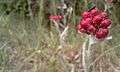 Rare Flower in Sakib
 Natural Reserve in Sakib
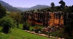 The road from Sakib to Wadi Rajib
 Spring in Sakib
Population
| Sakib population statistics | |||||||||||||
| Year | Population[37] | ||||||||||||
|---|---|---|---|---|---|---|---|---|---|---|---|---|---|
| 1538 | 13 households (only Sakib) | ||||||||||||
| 1596 | 12-13 households (Sakib) | ||||||||||||
| 1871 | 19 households (Sakib) | ||||||||||||
| 1922 | 800 | ||||||||||||
| 1988 | 5310 | ||||||||||||
| 1994 | 8250[1] | ||||||||||||
| 1996 | 8700[1] | ||||||||||||
| 1998 | 9,000[1] | ||||||||||||
| 2000 | 9,500[1] | ||||||||||||
| 2002 | 9,800[1] | ||||||||||||
| 2004 | 10,233 (estimate)[1] | ||||||||||||
As of 2012, all of the inhabitants of Sakib are Muslims. The 2012 estimate indicates that the population of Sakib is more than 17,000 people.
Education
There are several schools in various categories for both males and females, and people of Sakib have a high level of education.
Notes
- 1 2 3 4 5 6 7 "Population of Sakib". WolframAlpha. Retrieved 2012-06-29.
- 1 2 Hutteroth 1977, p. 165.
- ↑ Frederick Peake 1927, p. 331.
- ↑ Sulṭān 2009, p. 409.
- 1 2 Bakhit & Hamud 1991, p. 188.
- 1 2 3 4 5 6 7 8 9 10 11 12 13 14 15 16 17 18 Ayasrah.
- ↑ Zeitschrift des Deutschen Palästina-Vereins. Wiesbaden [etc.]: O. Harrassowitz [etc.]. Germany. 1988. p. 187
- ↑ Prawer 1980, p. 477.
- ↑ Conder 1885, p. 192.
- ↑ "Assets of the Byzantine cemetery in Sakib is an archaeological language and a historical value to Jordan" (Press release). © Alghad Newspaper (Jordan). 2008-02-27. Retrieved 2012-06-06.
- ↑ Abu Abila 2008, p. 1-10.
- ↑ "Neglecting ruins in Sakib" (Press release). © Al-Dustour Newspaper (Jordan). 2010-05-08. Retrieved 2012-06-29.
- ↑ Jum'a 2000, p. 8.
- ↑ Bakhit & Hamud 1989, p. 10.
- ↑ Bakhit & Hamud 1991, p. 10.
- ↑ Gharaibeh 2009, p. 13-35.
- ↑ Bakhit & Hamud 1991, p. 187-88.
- ↑ Bakhit & Hamud 1989, p. 26.
- ↑ Mughabghab 1900, p. 818-820.
- ↑ Seetzen 1854, p. v4.
- 1 2 Galodi 1994.
- 1 2 Eugene 1988.
- ↑ The Missionary Intelligencer 1869, p. 94.
- ↑ Jordan prime minister website: http://www.pm.gov.jo/arabic/index.php?page_type=pages&part=1&page_id=124
- ↑ The British Resident in Transjordan and the Financial Administration in the Emirate Transjordan 1921-1928. Journal of Politics and Law; Vol. 5, No. 4, (Canadian Center of Science and Education). 2012. ISSN 1913-9047
- ↑ Albert Victor, Prince Duke of Clarence and Avondale; George, King of Great Britain; John Neale Dalton 1886, p. 655.
- ↑ Conder 1885, p. 192-193.
- ↑ The Missionary Intelligencer 1869, p. 94.
- ↑ Smith & Bartholomew 1915, p. 9.
- ↑ Major cities near Sakib
- ↑ Google Maps
- ↑ Sakib City Guide & Information
- ↑ Meoweather Reporting Site
- ↑ The Euro+Med PlantBase - the information resource for Euro-Mediterranean plant diversity
- ↑ GBIF Data Portal
- ↑ The Royal Society for the Conservation of Nature
- ↑ Ayasrah, Emad (2011). The history of Sakib, unpublished work, Amman.
References
- This article depends on researcher & political analyst Emad Ayasrah's work, which is based on several sources.
- Abu Abila, Mohammad (2008). A Byzantine Cemetery at Sakib. Amman, Dept. of Antiquities, Hashemite Kingdom of Jordan.
- Albert Victor, Prince Duke of Clarence and Avondale; George, King of Great Britain; John Neale Dalton (1886). The cruise of Her Majesty's ship "Bacchante", 1879-1882. London, Macmillan and Co. ISBN 978-1177811873.
- Bakhit & Hamud, Muḥammad ʻAdnān & Nūfān Rajā (1991). Daftar mufaṣṣal Liwāʼ ʻAjlūn : ṭābū daftarī raqm 185, Anqarah sanat 1005 Hijrī muwāfiq 1596 Mīlādī = Kanunname-yi Liva-yı Aclun. (Detailed defter of Liwāʼ ʻAjlūn in year 1596). Amman, Jordan University.
- Bakhit & Hamud, Muḥammad ʻAdnān & Nūfān Rajā (1989). Daftar mufaṣṣal Liwāʼ ʻAjlūn : ṭābū daftarī raqm 970, Istānbūl = Kanunname-yi Liva-yı Aclun. (Detailed defter of Liwāʼ ʻAjlūn in year 1538). Amman, Jordan University.
- Frederick Peake (1927). Tarikh Shrki Alardn wa Kabaa'lha. (The history of East Jordan and its tribes.).
- Conder, Claude Reignier (1885), Heth and Moab : explorations in Syria in 1882, London : Richard Bentley & Son, ISBN 978-1279443477
- Ayasrah, Emad. Sakib: A Milestone in Jordan's History. Middle East Online - London.
- Eugene, Rogan (1988). Al-Salt, Jabal Ajlun and the Advent of Direct Ottoman Rule, The 1868 Travel Journal of F.A. Klein.
- Galodi, Alian (1994). District of Ajlun 1864-1918.
- Smith, George Adam; Bartholomew, J G (1915). Atlas of the historical geography of the Holy Land. London : Hodder & Stoughton. ISBN 978-1116660753.
- Gharaibeh, Khlaif Mustafa (April 2009), "Human Settlements in District of Ajloun and the southern part of Horan at the end of the 16th century 1596", Journal of Kufa Literatures (in Arabic), 4
- Hütteroth, Wolf-Dieter; Abdulfattah, Kamal (1977). Historical geography of Palestine, Transjordan and Southern Syria in the late 16th century. ISBN 3920405412.
- Jum'a, Mahmoud H Kareem (2000). The settlement patterns in the Jordan Valley in the mid- to late Islamic period. Oxford : Archaeopress. ISBN 9781841710785.
- Mughabghab, Naʻūm (1900). Tārīkh al-Amīr Ḥaydar Aḥmad al-Shihābī. (History of Prince Haydar Al Shihabi). Maṭbaʻat al-Salām.
- Prawer, Jushua (1980). Crusader Institutions. Oxford: Calarendon Press. ISBN 0-19-822536-9.
- Seetzen, Ulrich Jasper (1854). Reisen durch Syrien, Palästina, Phönicien, die Transjordan-länder, Arabia Petraea und Unter-Aegypten. Berlin, G. Reimer. ISBN 978-0543982742.
- Sulṭān, Fatḥī ʻAbd al-Qādir (2009). Mawsūʻat ansāb Āl al-Bayt al-Nabawī. (Lineage encyclopedia of Prophet Mohammad’s family, Aal-Albayte.). Amman: al-Dār al-ʻArabīyah lil-Mawsūʻāt.
- The Missionary Intelligencer (1869), The Missionary Intellingencer A Monthly Journal OF Missionary Information, 5, ISBN 978-1142006761
External links
| Wikimedia Commons has media related to Sakib. |