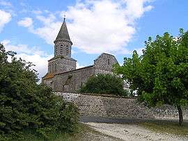
Saint-Simeux
| Saint-Simeux | |
|---|---|
 | |
 Saint-Simeux | |
|
Location within Nouvelle-Aquitaine region  Saint-Simeux | |
| Coordinates: 45°37′43″N 0°01′30″W / 45.6286°N 0.025°WCoordinates: 45°37′43″N 0°01′30″W / 45.6286°N 0.025°W | |
| Country | France |
| Region | Nouvelle-Aquitaine |
| Department | Charente |
| Arrondissement | Cognac |
| Canton | Châteauneuf-sur-Charente |
| Intercommunality | Châteauneuf |
| Government | |
| • Mayor (2008–2014) | Joël Trény |
| Area1 | 9.40 km2 (3.63 sq mi) |
| Population (2008)2 | 541 |
| • Density | 58/km2 (150/sq mi) |
| Time zone | CET (UTC+1) |
| • Summer (DST) | CEST (UTC+2) |
| INSEE/Postal code | 16351 / 16120 |
| Elevation |
16–99 m (52–325 ft) (avg. 50 m or 160 ft) |
|
1 French Land Register data, which excludes lakes, ponds, glaciers > 1 km² (0.386 sq mi or 247 acres) and river estuaries. 2 Population without double counting: residents of multiple communes (e.g., students and military personnel) only counted once. | |
Saint-Simeux is a commune in the Charente department in southwestern France.
Population
| Historical population | ||
|---|---|---|
| Year | Pop. | ±% |
| 1793 | 555 | — |
| 1800 | 583 | +5.0% |
| 1806 | 584 | +0.2% |
| 1821 | 579 | −0.9% |
| 1831 | 633 | +9.3% |
| 1841 | 529 | −16.4% |
| 1846 | 561 | +6.0% |
| 1851 | 582 | +3.7% |
| 1856 | 619 | +6.4% |
| 1861 | 620 | +0.2% |
| 1866 | 643 | +3.7% |
| 1872 | 568 | −11.7% |
| 1876 | 543 | −4.4% |
| 1881 | 518 | −4.6% |
| 1886 | 485 | −6.4% |
| 1891 | 453 | −6.6% |
| 1896 | 438 | −3.3% |
| 1901 | 436 | −0.5% |
| 1906 | 441 | +1.1% |
| 1911 | 419 | −5.0% |
| 1921 | 425 | +1.4% |
| 1926 | 401 | −5.6% |
| 1931 | 419 | +4.5% |
| 1936 | 369 | −11.9% |
| 1946 | 412 | +11.7% |
| 1954 | 411 | −0.2% |
| 1962 | 411 | +0.0% |
| 1968 | 374 | −9.0% |
| 1975 | 345 | −7.8% |
| 1982 | 366 | +6.1% |
| 1990 | 456 | +24.6% |
| 1999 | 452 | −0.9% |
| 2008 | 541 | +19.7% |
See also
References
| Wikimedia Commons has media related to Saint-Simeux. |
This article is issued from Wikipedia - version of the 2/12/2016. The text is available under the Creative Commons Attribution/Share Alike but additional terms may apply for the media files.