Saint-Pompont
| Saint-Pompon | |
|---|---|
 | |
 Saint-Pompon | |
|
Location within Nouvelle-Aquitaine region  Saint-Pompon | |
| Coordinates: 44°43′38″N 1°08′52″E / 44.7272°N 1.1478°ECoordinates: 44°43′38″N 1°08′52″E / 44.7272°N 1.1478°E | |
| Country | France |
| Region | Nouvelle-Aquitaine |
| Department | Dordogne |
| Arrondissement | Sarlat-la-Canéda |
| Canton | Domme |
| Intercommunality | Canton of Domme |
| Government | |
| • Mayor (2008–2014) | Thomas Michel |
| Area1 | 27.40 km2 (10.58 sq mi) |
| Population (2008)2 | 440 |
| • Density | 16/km2 (42/sq mi) |
| Time zone | CET (UTC+1) |
| • Summer (DST) | CEST (UTC+2) |
| INSEE/Postal code | 24488 / 24170 |
| Elevation |
110–334 m (361–1,096 ft) (avg. 131 m or 430 ft) |
|
1 French Land Register data, which excludes lakes, ponds, glaciers > 1 km² (0.386 sq mi or 247 acres) and river estuaries. 2 Population without double counting: residents of multiple communes (e.g., students and military personnel) only counted once. | |
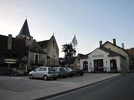
Saint-Pompont is a commune in the Dordogne department in Nouvelle-Aquitaine in southwestern France.
Population
| Historical population | ||
|---|---|---|
| Year | Pop. | ±% |
| 1962 | 536 | — |
| 1968 | 516 | −3.7% |
| 1975 | 506 | −1.9% |
| 1982 | 521 | +3.0% |
| 1990 | 452 | −13.2% |
| 1999 | 404 | −10.6% |
| 2008 | 440 | +8.9% |
See also
References
| Wikimedia Commons has media related to Saint-Pompont. |
This article is issued from Wikipedia - version of the 11/9/2016. The text is available under the Creative Commons Attribution/Share Alike but additional terms may apply for the media files.