Saint-Paul-lès-Dax
| Saint-Paul-lès-Dax | ||
|---|---|---|
|
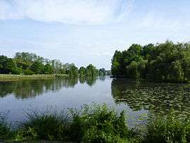
Christus Lake | ||
| ||
 Saint-Paul-lès-Dax | ||
|
Location within Nouvelle-Aquitaine region  Saint-Paul-lès-Dax | ||
| Coordinates: 43°43′35″N 1°03′06″W / 43.7264°N 1.0517°WCoordinates: 43°43′35″N 1°03′06″W / 43.7264°N 1.0517°W | ||
| Country | France | |
| Region | Nouvelle-Aquitaine | |
| Department | Landes | |
| Arrondissement | Dax | |
| Canton | Dax-Nord | |
| Intercommunality | Grand Dax | |
| Government | ||
| • Mayor (2014–2020) | Catherine Delmon | |
| Area1 | 58.45 km2 (22.57 sq mi) | |
| Population (2013)2 | 12,956 | |
| • Density | 220/km2 (570/sq mi) | |
| Time zone | CET (UTC+1) | |
| • Summer (DST) | CEST (UTC+2) | |
| INSEE/Postal code | 40279 / 40990 | |
| Elevation |
2–61 m (6.6–200.1 ft) (avg. 22 m or 72 ft) | |
|
1 French Land Register data, which excludes lakes, ponds, glaciers > 1 km² (0.386 sq mi or 247 acres) and river estuaries. 2 Population without double counting: residents of multiple communes (e.g., students and military personnel) only counted once. | ||
.svg.png)
Saint-Paul-lès-Dax is a commune in the Landes department in Nouvelle-Aquitaine in southwestern France.
Population
| Historical population | ||
|---|---|---|
| Year | Pop. | ±% |
| 1793 | 1,013 | — |
| 1806 | 1,078 | +6.4% |
| 1821 | 1,324 | +22.8% |
| 1831 | 1,708 | +29.0% |
| 1841 | 2,027 | +18.7% |
| 1851 | 3,022 | +49.1% |
| 1861 | 2,817 | −6.8% |
| 1872 | 3,019 | +7.2% |
| 1881 | 3,240 | +7.3% |
| 1891 | 3,614 | +11.5% |
| 1901 | 3,720 | +2.9% |
| 1911 | 3,948 | +6.1% |
| 1921 | 3,718 | −5.8% |
| 1931 | 3,956 | +6.4% |
| 1946 | 4,225 | +6.8% |
| 1954 | 4,316 | +2.2% |
| 1962 | 5,037 | +16.7% |
| 1968 | 5,795 | +15.0% |
| 1975 | 8,220 | +41.8% |
| 1982 | 9,028 | +9.8% |
| 1990 | 9,452 | +4.7% |
| 1999 | 10,226 | +8.2% |
| 2008 | 12,544 | +22.7% |
| 2013 | 12,956 | +3.3% |
See also
References
| Wikimedia Commons has media related to Saint-Paul-lès-Dax. |
This article is issued from Wikipedia - version of the 11/10/2016. The text is available under the Creative Commons Attribution/Share Alike but additional terms may apply for the media files.