Saint-Martin-le-Pin
| Saint-Martin-le-Pin | |
|---|---|
 | |
 Saint-Martin-le-Pin | |
|
Location within Nouvelle-Aquitaine region  Saint-Martin-le-Pin | |
| Coordinates: 45°33′24″N 0°36′43″E / 45.5567°N 0.6119°ECoordinates: 45°33′24″N 0°36′43″E / 45.5567°N 0.6119°E | |
| Country | France |
| Region | Nouvelle-Aquitaine |
| Department | Dordogne |
| Arrondissement | Nontron |
| Canton | Nontron |
| Government | |
| • Mayor (2008–2014) | Marcel Lavoix |
| Area1 | 15.54 km2 (6.00 sq mi) |
| Population (2008)2 | 299 |
| • Density | 19/km2 (50/sq mi) |
| Time zone | CET (UTC+1) |
| • Summer (DST) | CEST (UTC+2) |
| INSEE/Postal code | 24458 / 24300 |
| Elevation |
127–302 m (417–991 ft) (avg. 135 m or 443 ft) |
|
1 French Land Register data, which excludes lakes, ponds, glaciers > 1 km² (0.386 sq mi or 247 acres) and river estuaries. 2 Population without double counting: residents of multiple communes (e.g., students and military personnel) only counted once. | |
Saint-Martin-le-Pin (Sent Martin lu Pench in Occitan[1] ) is a commune in the Dordogne department in Nouvelle-Aquitaine in southwestern France. It is part of the Regional Natural Park Périgord Limousin.
Geography

Saint-Martin-le-Pin is situated along the D 94 about 5 kilometers northwest of Nontron. The boundary with Nontron to the southeast is the Ruisseau des Vergnes, a southwest-flowing right tributary of the Bandiat. The commune's territory reaches the Bandiat river itself in the southwest, forming a natural boundary with the neighbouring communes Saint-Martial-de-Valette in the south and Lussas-et-Nontronneau in the southwest. The commune's boundary to Javerlhac-et-la-Chapelle-Saint-Robert in the northwest and Le Bourdeix farther north is the Doue river, also a smaller right tributary of the Bandiat.
Saint-Martin-le-Pin can also be reached via the D 75 following the Bandiat valley from Nontron to Javerlhac.
Besides the main village there are lots of little hamlets and single farms for example Ars, Blanchetière, Chantemerle, Chez Thomas, Crachat, Jourdonnières, La Borderie, La Combe au Cros, La Tuilière, Le Moulin de chez Jouanaud, Les Cazes, Lespinasse, Loradour, Mérignac, Pas Brouillet, Ribeyrolle, Talivaud, and Tranchecouyère.
Geology
The commune's territory is underlain in its totality by Variscan basement rocks (Piégut-Pluviers Granodiorite). Transgressing the basement from the West are liassic sediments belonging to the Aquitanian Basin. The base conglomerate can be seen near La Chapoulie. Stratigraphically higher follow arkoses, dolostones and limestones. A NW-SE striking fault zone originating in Nontron traverses the territory and raises the Northeastern basement block. Movements along this fault zone must have been going on well into the Pleistocene, because one can observe stream rejuvenation along some of the southwestward-draining creeks. This fault zone is strongly mineralised in mainly baryte, but there is also galena, sphalerite, pyrite and the rather rare cadmium mineral greenockite.[2] This fault zone has been mined in the past, the shaft of the mine de la Mairie [3] still can be seen in the village. Associated with the ores is an intensive recrystallization and silicification of the country rocks along the fault line. Between 1825 and 1850 manganese was mined near Talivaud in the contact region between the arkoses and the overlying Sidérolithique, iron-rich Tertiary sediments.
The limestones sometimes develop karst phenomena like caves (near Blanchetière).
The floodplain of the Bandiat is infilled by alluvial Pleistocene sands with occasional intercalated layers of polished quartz pebbles.
History
The romanesque village church Saint-Martin dates back to the 12th century and has been classified in 1942 as Monument historique.[4][5] Remarkable is its entry.
Before 1789 the commune was called Saint-Martin-le-Peint.[6] Saint Martin therefore was not associated with the pine tree, but rather was "painted".
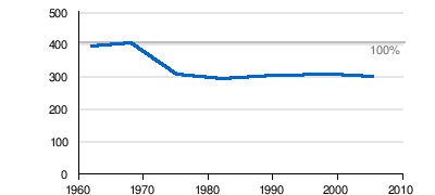
Population
| Historical population | ||
|---|---|---|
| Year | Pop. | ±% |
| 1962 | 394 | — |
| 1968 | 405 | +2.8% |
| 1975 | 311 | −23.2% |
| 1982 | 292 | −6.1% |
| 1990 | 303 | +3.8% |
| 1999 | 305 | +0.7% |
| 2008 | 299 | −2.0% |
The population has suffered a serious set-back after 1968, but has stabilised since 1975.
Gallery
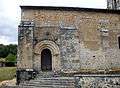 Entry
Entry The Bandiat river downstream from the bridge near Ars
See also
References
- ↑ Occitan names of the communes in the Périgord, website of the Conseil général de la Dordogne
- ↑ P. Didier. Les espèces minerales du Limousin.
- ↑ Saint-Martin-le-Pin on mindat.org
- ↑ Church of Saint-Martin-le-Pin amongst the Mérimée data of the French Ministry of Education
- ↑ Romanesque church of Saint-Martin-le-Pin on route-romane.net
- ↑ Cassini map on Géoportail
External links
| Wikimedia Commons has media related to Saint-Martin-le-Pin. |