Saint-Gervais-sur-Mare
| Saint-Gervais-sur-Mare | ||
|---|---|---|
|
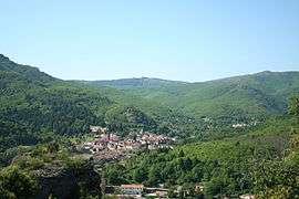
A general view of Saint-Gervais-sur-Mare | ||
| ||
 Saint-Gervais-sur-Mare | ||
|
Location within Occitanie region  Saint-Gervais-sur-Mare | ||
| Coordinates: 43°39′10″N 3°02′27″E / 43.6528°N 3.0408°ECoordinates: 43°39′10″N 3°02′27″E / 43.6528°N 3.0408°E | ||
| Country | France | |
| Region | Occitanie | |
| Department | Hérault | |
| Arrondissement | Béziers | |
| Canton | Saint-Gervais-sur-Mare | |
| Intercommunality | Monts d'Orb | |
| Government | ||
| • Mayor (2008–2014) | Jean-Luc Falip | |
| Area1 | 24.29 km2 (9.38 sq mi) | |
| Population (2008)2 | 824 | |
| • Density | 34/km2 (88/sq mi) | |
| Time zone | CET (UTC+1) | |
| • Summer (DST) | CEST (UTC+2) | |
| INSEE/Postal code | 34260 / 34610 | |
| Elevation |
280–940 m (920–3,080 ft) (avg. 330 m or 1,080 ft) | |
|
1 French Land Register data, which excludes lakes, ponds, glaciers > 1 km² (0.386 sq mi or 247 acres) and river estuaries. 2 Population without double counting: residents of multiple communes (e.g., students and military personnel) only counted once. | ||

Saint-Gervais-sur-Mare is a commune in the Hérault department in the Occitanie region in southern France.
Population
| Historical population | ||
|---|---|---|
| Year | Pop. | ±% |
| 1962 | 650 | — |
| 1968 | 873 | +34.3% |
| 1975 | 860 | −1.5% |
| 1982 | 859 | −0.1% |
| 1990 | 813 | −5.4% |
| 1999 | 789 | −3.0% |
| 2008 | 824 | +4.4% |
See also
References
| Wikimedia Commons has media related to Saint-Gervais-sur-Mare. |
This article is issued from Wikipedia - version of the 11/12/2016. The text is available under the Creative Commons Attribution/Share Alike but additional terms may apply for the media files.