Saint-Genès-la-Tourette
| Saint-Genès-la-Tourette | |
|---|---|
 Saint-Genès-la-Tourette | |
|
Location within Auvergne-Rhône-Alpes region  Saint-Genès-la-Tourette | |
| Coordinates: 45°31′N 3°28′E / 45.51°N 3.47°ECoordinates: 45°31′N 3°28′E / 45.51°N 3.47°E | |
| Country | France |
| Region | Auvergne-Rhône-Alpes |
| Department | Puy-de-Dôme |
| Arrondissement | Issoire |
| Canton | Sauxillanges |
| Intercommunality | Pays de Sauxillanges |
| Government | |
| • Mayor (2001–2008) | Pierre-Luc Fraisse |
| Area1 | 18.49 km2 (7.14 sq mi) |
| Population (2006)2 | 188 |
| • Density | 10/km2 (26/sq mi) |
| Time zone | CET (UTC+1) |
| • Summer (DST) | CEST (UTC+2) |
| INSEE/Postal code | 63348 / 63580 |
| Elevation |
639–1,046 m (2,096–3,432 ft) (avg. 790 m or 2,590 ft) |
|
1 French Land Register data, which excludes lakes, ponds, glaciers > 1 km² (0.386 sq mi or 247 acres) and river estuaries. 2 Population without double counting: residents of multiple communes (e.g., students and military personnel) only counted once. | |
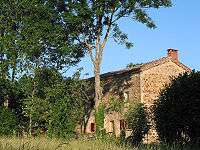
Ancient farm in the Maredon hamlet.
Saint-Genès-la-Tourette is a commune in the Puy-de-Dôme department in Auvergne in central France.
See also
References
| Wikimedia Commons has media related to Saint-Genès-la-Tourette. |
This article is issued from Wikipedia - version of the 11/14/2014. The text is available under the Creative Commons Attribution/Share Alike but additional terms may apply for the media files.