Saint-François-de-Sales
| Saint-François-de-Sales | |
|---|---|
|
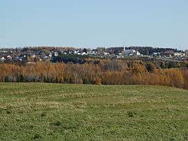
A general view of Saint-François-de-Sales | |
 Saint-François-de-Sales | |
|
Location within Auvergne-Rhône-Alpes region  Saint-François-de-Sales | |
| Coordinates: 45°40′55″N 6°03′21″E / 45.6819°N 6.0558°ECoordinates: 45°40′55″N 6°03′21″E / 45.6819°N 6.0558°E | |
| Country | France |
| Region | Auvergne-Rhône-Alpes |
| Department | Savoie |
| Arrondissement | Chambéry |
| Canton | Le Châtelard |
| Intercommunality | Pays des Bauges |
| Government | |
| • Mayor (2008–2014) | Dominique Gauthier |
| Area1 | 14.44 km2 (5.58 sq mi) |
| Population (2006)2 | 142 |
| • Density | 9.8/km2 (25/sq mi) |
| Time zone | CET (UTC+1) |
| • Summer (DST) | CEST (UTC+2) |
| INSEE/Postal code | 73234 / 73340 |
| Elevation | 697–1,432 m (2,287–4,698 ft) |
|
1 French Land Register data, which excludes lakes, ponds, glaciers > 1 km² (0.386 sq mi or 247 acres) and river estuaries. 2 Population without double counting: residents of multiple communes (e.g., students and military personnel) only counted once. | |
Saint-François-de-Sales is a commune in the Savoie department in the Auvergne-Rhône-Alpes region in south-eastern France.
See also
References
| Wikimedia Commons has media related to Saint-François-de-Sales (Savoie). |
This article is issued from Wikipedia - version of the 10/28/2016. The text is available under the Creative Commons Attribution/Share Alike but additional terms may apply for the media files.