Saint-François, Guadeloupe
| Saint-François | |
|---|---|
|
The town hall of Saint-François | |
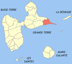 Location of the commune (in red) within Guadeloupe | |
| Coordinates: 16°15′00″N 61°17′00″W / 16.25000°N 61.2833°WCoordinates: 16°15′00″N 61°17′00″W / 16.25000°N 61.2833°W | |
| Country | France |
| Overseas region and department | Guadeloupe |
| Arrondissement | Pointe-à-Pitre |
| Canton | Saint-François |
| Government | |
| • Mayor | Laurent Bernier |
| Area1 | 61.00 km2 (23.55 sq mi) |
| Population (2013)2 | 14,965 |
| • Density | 250/km2 (640/sq mi) |
| INSEE/Postal code | 97125 / 97118 |
| Elevation | 0–67 m (0–220 ft) |
|
1 French Land Register data, which excludes lakes, ponds, glaciers > 1 km² (0.386 sq mi or 247 acres) and river estuaries. 2 Population without double counting: residents of multiple communes (e.g., students and military personnel) only counted once. | |

Saint-François is part of the Caribbean island of Guadeloupe. It is a commune on this French overseas department. Saint-François is situated on the south-east point of the main island, Grande-Terre.
Geography
A number of settlements exist within the commune of Saint-François:
See also
External links
- Office de Tourisme de Saint François – Official site of the Saint-François Tourism Board
References
| Wikimedia Commons has media related to Saint-François (Guadeloupe). |
This article is issued from Wikipedia - version of the 4/22/2016. The text is available under the Creative Commons Attribution/Share Alike but additional terms may apply for the media files.