Saint-Broladre
| Saint-Broladre Sant-Brewalaer | ||
|---|---|---|
|
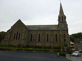
The church of Saint-Broladre | ||
| ||
 Saint-Broladre | ||
|
Location within Brittany region  Saint-Broladre | ||
| Coordinates: 48°35′15″N 1°39′19″W / 48.5875°N 1.6553°WCoordinates: 48°35′15″N 1°39′19″W / 48.5875°N 1.6553°W | ||
| Country | France | |
| Region | Brittany | |
| Department | Ille-et-Vilaine | |
| Arrondissement | Saint-Malo | |
| Canton | Pleine-Fougères | |
| Intercommunality | Baie du Mont-Saint-Michel | |
| Government | ||
| • Mayor (2014–2020) | Guy Videloup | |
| Area1 | 23.81 km2 (9.19 sq mi) | |
| Population (2009)2 | 1,094 | |
| • Density | 46/km2 (120/sq mi) | |
| Time zone | CET (UTC+1) | |
| • Summer (DST) | CEST (UTC+2) | |
| INSEE/Postal code | 35259 / 35120 | |
| Elevation | 1–102 m (3.3–334.6 ft) | |
|
1 French Land Register data, which excludes lakes, ponds, glaciers > 1 km² (0.386 sq mi or 247 acres) and river estuaries. 2 Population without double counting: residents of multiple communes (e.g., students and military personnel) only counted once. | ||
.svg.png)
Saint-Broladre (Breton: Sant-Brewalaer) is a commune in the Ille-et-Vilaine department in Brittany in northwestern France.
Population
Inhabitants of Saint-Broladre are called Broladrais or Broladriens in French.
| Historical population | ||
|---|---|---|
| Year | Pop. | ±% |
| 1962 | 884 | — |
| 1968 | 946 | +7.0% |
| 1975 | 881 | −6.9% |
| 1982 | 865 | −1.8% |
| 1990 | 992 | +14.7% |
| 1999 | 1,014 | +2.2% |
| 2009 | 1,094 | +7.9% |
See also
References
External links
| Wikimedia Commons has media related to Saint-Broladre. |
This article is issued from Wikipedia - version of the 11/6/2015. The text is available under the Creative Commons Attribution/Share Alike but additional terms may apply for the media files.